
Edit header | Sandboxes: 1 2 3 4
To-do list
|
|---|
|
 Yutu at peak intensity west of the Northern Mariana Islands on October 25 | |
| Meteorological history | |
|---|---|
| Formed | October 21, 2018 |
| Remnant low | November 2, 2018 |
| Dissipated | November 3, 2018 |
| Violent typhoon | |
| 10-minute sustained (JMA) | |
| Highest winds | 215 km/h (130 mph) |
| Lowest pressure | 900 hPa (mbar); 26.58 inHg |
| Category 5-equivalent super typhoon | |
| 1-minute sustained (SSHWS/JTWC) | |
| Highest winds | 280 km/h (175 mph) |
| Lowest pressure | 904 hPa (mbar); 26.70 inHg |
| Overall effects | |
| Fatalities | 30 |
| Damage | $854 million (2018 USD) |
| Areas affected | Caroline Islands, Mariana Islands (particularly Tinian and Saipan), Philippines, South China |
Part of the 2018 Pacific typhoon season | |
Typhoon Yutu, known in the Philippines as Super Typhoon Rosita, was an extremely powerful tropical cyclone that caused catastrophic destruction on the islands of Tinian and Saipan in the Northern Mariana Islands, and later impacted the Philippines. It is the strongest typhoon ever recorded to impact the Mariana Islands, and is tied as the second-strongest tropical cyclone to strike the United States and its unincorporated territories by both wind speed and barometric pressure. It also tied Typhoon Kong-rey as the most powerful tropical cyclone worldwide in 2018.
Meteorological history
edit
Tropical storm (39–73 mph, 63–118 km/h)
Category 1 (74–95 mph, 119–153 km/h)
Category 2 (96–110 mph, 154–177 km/h)
Category 3 (111–129 mph, 178–208 km/h)
Category 4 (130–156 mph, 209–251 km/h)
Category 5 (≥157 mph, ≥252 km/h)
Unknown
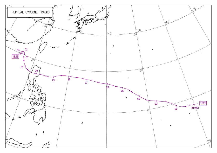
On October 20, the Japan Meteorological Agency (JMA) began monitoring an area of low atmospheric pressure moving westward.[1] Located 1,817 km (1,129 mi) east-southeast of Andersen Air Force Base in Guam, the disturbance was situated in an environment of favorable conditions for potential tropical cyclogenesis such as substantial equatorward outflow, low vertical wind shear, and very warm sea surface temperatures of 30–32 °C (86–90 °F). Within the system's center was an elongated surface circulation with deep atmospheric convection—or showers and thunderstorms—wrapping into it.[2] By 18:00 UTC, the JMA reported that the disturbance had intensified into a tropical depression around the Marshall Islands.[3] Eighteen hours later on October 21, the United States Joint Typhoon Warning Center (JTWC) designated the consolidating system 31W.[4] As the cyclone began to steer west-northwestward around a subtropical ridge to its southwest, radial outflow was limited by a weak tropical upper tropospheric trough (TUTT) cell to the system's northwest,[5] though it soon de-amplified the next day.[6] At 00:00 UTC of October 22, both the JMA and JTWC assigned the tropical depression a tropical storm, with the former giving it the name Yutu.[3][7]
The system expanded as favorable conditions continued to fuel it, with the most intense thunderstorms positioned to the east and south of the center.[8] Yutu significantly improved its structure, marking the beginning of a period of rapid intensification.[9] At 18:00 UTC, the JMA upgraded Yutu to a severe tropical storm, and six hours later on October 23, both the JMA and JTWC classified the storm as a typhoon.[3][7] As rainbands tightened toward the center, an eye became apparent on satellite imagery.[10] While being over a region of high ocean heat content, the eye became well-defined and expanded to 43 km (26 mi).[11] Although the eye soon shrunk, by early the next day, Yutu was classified a super typhoon by the JTWC.[12] By 12:00 UTC, the JMA and JTWC reported that Typhoon Yutu had attained its initial peak intensity, with the former estimating maximum sustained winds of 215 km/h (130 mph) and a barometric pressure of 900 hPa (26.58 inHg), and the latter estimating 1-minute sustained winds of 280 km/h (175 mph), making Yutu equivalent to a Category 5 hurricane on the Saffir–Simpson scale.[3][7]
Continuing northwestward, Yutu was positioned 56 km (35 mi) west-northwest of Saipan as it approached the island. Concurrently, cold cloud tops began to warm, signaling a weakening trend. Furthermore, microwave imagery revealed concentric eyewalls, indicating the onset of an eyewall replacement cycle.[13] Around 16:00 UTC (02:00 ChST of October 25), Yutu struck Tinian and the southern portion of Saipan with winds of 290 km/h (180 mph),[14] becoming the most powerful storm on record to impact the Northern Mariana Islands.[15][16] The eastern periphery of the eyewall thinned under the influence of dry air in the middle troposphere,[17] while the storm maintained its robust convection around the cooling, shrinking eye.[18] The cycle was then completed, evident by a Special Sensor Microwave Imager/Sounder image.[19] The eye again became well-defined, as low easterly wind shear and excellent outflow persisted, despite an upper-level anticyclone restricting the outflow from the east,[20] and by 12:00 UTC of October 26, the JMA and the JTWC reported that Yutu had attained its secondary peak intensity; the JMA estimated winds of 195 km/h (120 mph) and a minimum barometric pressure of 915 hPa (27.02 inHg), and the JTWC gave Yutu the same estimate as the previous.[3][7]
While over the Philippine Sea, which contained high ocean heat content,[21] Yutu crossed the 135°E boundary of the Philippine Area of Responsibility at 00:00 UTC of October 27, receiving the local name Rosita from the PAGASA—the national weather agency for the Philippines.[22]
Preparations
editMariana Islands
editOn October 20, the National Weather Service (NWS) office in Tiyan, Guam released a Special Weather Statement on the pre-Yutu disturbance after a Tropical Cyclone Formation Alert from the JTWC was issued, stating that it could impact the Mariana Islands by midweek.[23] Two days later, the NWS instated a tropical storm watch for Rota and a typhoon watch on Saipan and Tinian.[24] As Tropical Storm Yutu continued towards the archipelago, tropical storm watches were added on Guam, Alamagan, Pagan, and Agrihan.[25] With forecasts stating that Yutu would become a typhoon, the watches for Saipan and Tinian were upgraded to warnings on October 23;[26] all tropical storm watches were also upgraded to warnings later that day, and the typhoon watch for Rota was upgraded to a warning also.[27]
Condition of Readiness 2 was hoisted in Rota, Saipan, and Tinian on October 23,[28] before it was upgraded to COR 1 the next day after Yutu had become a super typhoon on that day.[29] Governor Ralph Torres ordered all government offices to shut down in preparation of Yutu.[30] Additionally, Northern Marianas College campuses were closed on October 23.[31] The Chief Judge of the District Court, Ramona Villagomez Manglona, closed the federal court.[32] Attorney General Edward Manibusan warned retailers against price gouging.[33] Public schools canceled classes across the three main islands; seven were used to accommodate 326 people.[34] Federal Emergency Management Agency (FEMA) personnel deployed to both Tinian and Saipan ahead of the storm. U.S. President Donald Trump declared an emergency for the Northern Islands on October 24.[35]
COR 2 was also hoisted in Guam,[29] before it was upgraded to COR 1.[36] Governor Eddie Baza Calvo declared a state of emergency in anticipation of the typhoon.[37] The Guam Department of Education closed all of its schools,[38] with eight of them turned into emergency shelters to accommodate nearly 2,200 people.[39] Catholic schools and charter schools were closed as well. St. John's School, the University of Guam, Guam Community College, and Harvest Christian Academy were also closed. The Guam Regional Transit Authority halted bus operations in response to the COR 2, and transit services were paused until two hours after COR 4—the normal Condition of Readiness. Banks were closed across the island, along with post offices, and all government agencies. The Legislature, Judiciary, and District Court were all closed as well. Guam Memorial Hospital, Guam Regional Medical City, and Naval Hospital Guam suspended all operations. Two Lovers Point and the War in the Pacific National Historical Park were closed.[38] In the month prior to Yutu, Typhoon Mangkhut struck the Mariana Islands, prompting emergency officials to stockpile supplies. With relief supplies largely unused, storage facilities on Guam had 220,000 liters of water and 260,000 meals readily available.[40] Flights to and from Antonio B. Won Pat International Airport were canceled.[41]
Philippines
editElsewhere
editImpact
editMariana Islands
editGuam endured tropical storm winds of 48–64 km/h (30–40 mph) and gusts of 80 km/h (50 mph).[42] The Guam Power Authority reported power outages over some parts of the island,[43] and no major damage or injuries from Yutu were reported.[44] As such, Guam was placed in COR 4 on October 25.[45]
Philippines
editElsewhere
editAftermath
editRetirement
editSee also
edit- Weather of 2018
- Tropical cyclones in 2018
- Typhoon Karen (1962) – Devastated Guam in a similar fashion.
- Typhoon Lynn (1987) – Hit the Marianas and skirted through Luzon.
- Typhoon Nina (1987) – Hit both the Marianas and Philippines, though the latter country faced the stronger landfall.
- Typhoon Soudelor (2015) – Also majorly damaged the Northern Mariana Islands, partially led to its retirement.
- Typhoon Mangkhut (2018) – Affected the Mariana Islands and northern Luzon less than two months earlier, also caused extensive damage.
- Typhoon Hagibis (2019) – Also affected the Marianas as it was rapidly intensifying.
- Typhoon Mawar (2023) – A Category-5 equivalent typhoon that passed near Guam, bringing strong winds in that area.
References
edit- ^ Warning and Summary 200000 (Report). Tokyo, Japan: Japan Meteorological Agency. October 20, 2018. Retrieved August 26, 2024 – via Iowa Environmental Mesonet.
- ^ Tropical Cyclone Formation Alert (202130 October 2018) (Report). Pearl Harbor, Hawaii: Joint Typhoon Warning Center. October 20, 2019. Retrieved August 26, 2024 – via Iowa Environmental Mesonet.
- ^ a b c d e Annual Report on the Activities of the RSMC Tokyo - Typhoon Center 2018 (PDF) (Report). Tokyo, Japan: Japan Meteorological Agency. 2019. Retrieved August 27, 2024.
- ^ Prognostic Reasoning for Tropical Depression 31W (Thirty-one) Warning No. 1 (Report). Pearl Harbor, Hawaii: Joint Typhoon Warning Center. October 20, 2018. Retrieved August 26, 2024 – via Iowa Environmental Mesonet.
- ^ Prognostic Reasoning for Tropical Depression 31W (Thirty-one) Warning No. 2 (Report). Pearl Harbor, Hawaii: Joint Typhoon Warning Center. October 21, 2018. Retrieved August 27, 2024 – via Iowa Environmental Mesonet.
- ^ Prognostic Reasoning for Tropical Storm 31W (Yutu) Warning No. 3 (Report). Joint Typhoon Warning Center. October 22, 2018. Retrieved August 27, 2024 – via Iowa Environmental Mesonet.
- ^ a b c d Chu, J. H.; Levine, A.; Daida, S.; Schiber, D.; Fukada, E.; Sampson, C. R. 2018 Western North Pacific Ocean Best Track Data (Report). Pearl Harbor, Hawaii: Joint Typhoon Warning Center. Retrieved April 9, 2024.
- ^ Prognostic Reasoning for Tropical Storm 31W (Yutu) Warning No. 4 (Report). Pearl Harbor, Hawaii: Joint Typhoon Warning Center. October 22, 2018. Retrieved August 27, 2024 – via Iowa Environmental Mesonet.
- ^ Prognostic Reasoning for Tropical Storm 31W (Yutu) Warning No. 6 (Report). Pearl Harbor, Hawaii: Joint Typhoon Warning Center. October 22, 2018. Retrieved August 27, 2024 – via Iowa Environmental Mesonet.
- ^ Prognostic Reasoning for Typhoon 31W (Yutu) Warning No. 7 (Report). Pearl Harbor, Hawai: Joint Typhoon Warning Center. October 23, 2018. Retrieved August 29, 2024 – via Iowa Environmental Mesonet.
- ^ Prognostic Reasoning for Typhoon 31W (Yutu) Warning No. 10 (Report). Pearl Harbor, Hawaii: Joint Typhoon Warning Center. October 23, 2018. Retrieved August 29, 2024 – via Iowa Environmental Mesonet.
- ^ Prognostic Reasoning for Super Typhoon 31W (Yutu) Warning No. 11 (Report). Pearl Harbor, Hawaii: Joint Typhoon Warning Center. October 24, 2018. Retrieved September 6, 2024 – via Iowa Environmental Mesonet.
- ^ Prognostic Reasoning for Super Typhoon 31W (Yutu) Warning No. 14 (Report). Pearl Harbor, Hawaii: Joint Typhoon Warning Center. October 24, 2018. Retrieved September 6, 2024 – via Iowa Environmental Mesonet.
- ^ ...EYE OF SUPER TYPHOON YUTU OVER TINIAN AND SAIPAN... (Report). Tiyan, Guam: National Weather Service. October 24, 2018. Retrieved September 13, 2024 – via Iowa Environmental Mesonet.
- ^ Colin Dwyer (October 24, 2018). "Super Typhoon Yutu, 'Strongest Storm Of 2018,' Slams U.S. Pacific Territory". NPR. Retrieved October 25, 2018.
- ^ "Typhoon Yutu Was the Strongest Tropical Cyclone on Record to Pass Over Saipan and Tinian in the Northern Mariana Islands (RECAP)". The Weather Company. October 28, 2018. Retrieved October 29, 2018.
- ^ Yutu (T1826) (PDF) (Report). Tokyo, Japan: Japan Meteorological Agency. Retrieved September 10, 2024.
- ^ Prognostic Reasoning for Super Typhoon 31W (Yutu) Warning No. 17 (Report). Pearl Harbor, Hawaii: Joint Typhoon Warning Center. October 25, 2018. Retrieved September 10, 2024 – via Iowa Environmental Mesonet.
- ^ Prognostic Reasoning for Super Typhoon 31W (Yutu) Warning No. 18 (Report). Pearl Harbor, Hawaii: Joint Typhoon Warning Center. October 25, 2018. Retrieved September 11, 2024 – via Iowa Environmental Mesonet.
- ^ Prognostic Reasoning for Super Typhoon 31W (Yutu) Warning No. 20 (Report). Pearl Harbor, Hawaii: Joint Typhoon Warning Center. October 26, 2018. Retrieved September 11, 2024 – via Iowa Environmental Mesonet.
- ^ Prognostic Reasoning for Super Typhoon 31W (Yutu) Warning No. 22 (Report). Pearl Harbor, Hawaii: Joint Typhoon Warning Center. October 26, 2018. Retrieved September 12, 2024 – via Iowa Environmental Mesonet.
- ^ Duran, Samuel F.; Galang, Juanito S.; Gile, Robb P.; Reyes, Sheilla Mae R.; Tolentino, Jerome T. (June 2020). DOST-PAGASA Annual Report on Philippine Tropical Cyclones 2018 (PDF) (Report). Quezon City, Philippines: Government of the Republic of the Philippines Department of Science and Technology: Philippine Atmospheric, Geophysical, and Astronomical Services Administration. p. 58. ISSN 2672-3190. Retrieved September 12, 2024.
- ^ ...TROPICAL DISTURBANCE COULD IMPACT THE MARIANAS BY MIDWEEK... (Report). Tiyan, Guam: National Weather Service. October 20, 2018. Retrieved September 13, 2024 – via Iowa Environmental Mesonet.
- ^ ...TYPHOON AND TROPICAL STORM WATCHES ISSUED... (Report). Tiyan, Guam: National Weather Service. October 22, 2018. Retrieved September 13, 2024 – via Iowa Environmental Mesonet.
- ^ ...TROPICAL STORM YUTU CONTINUING TOWARD THE MARIANAS... (Report). Tiyan, Guam: National Weather Service. October 23, 2018. Retrieved September 13, 2024 – via Iowa Environmental Mesonet.
- ^ ...TROPICAL STORM YUTU CONTINUING TO MOVE TOWARD THE MARIANAS... (Report). Tiyan, Guam: National Weather Service. October 23, 2018. Retrieved September 13, 2024 – via Iowa Environmental Mesonet.
- ^ ...TYPHOON YUTU INTENSIFYING AS IT APPROACHES THE MARIANAS... (Report). Tiyan, Guam: National Weather Service. October 23, 2018. Retrieved September 13, 2024 – via Iowa Environmental Mesonet.
- ^ ...TYPHOON YUTU INTENSIFYING AS IT APPROACHES THE MARIANAS... (Report). Tiyan, Guam: National Weather Service. October 23, 2018. Retrieved September 16, 2024 – via Iowa Environmental Mesonet.
- ^ a b ...YUTU UPGRADED TO SUPER TYPHOON... (Report). Tiyan, Guam: National Weather Service. October 24, 2018. Retrieved September 13, 2024 – via Iowa Environmental Mesonet.
- ^ "Govt offices close early today". Saipan Tribune. October 23, 2018. Retrieved September 16, 2024.
- ^ "BREAKING NEWS: NMC on Saipan, Tinian closed today". Saipan Tribune. October 23, 2018. Retrieved September 16, 2024.
- ^ Torre, Ferdie De La (October 24, 2018). "District court closed, reopens tomorrow". Saipan Tribune. Retrieved September 16, 2024.
- ^ "OAG warns against price gouging". Saipan Tribune. October 24, 2018. Retrieved September 16, 2024.
- ^ Encinares, Erwin (October 24, 2018). "Shelters activated". Saipan Tribune. Retrieved September 16, 2024.
- ^ Chris Mooney, Juliet Eilperin, and Allyson Chiu (October 25, 2018). "Category 5 typhoon Yutu devastates the Northern Marianas in worst storm to hit any part of U.S. since 1935". The Washington Post. Retrieved October 26, 2018.
{{cite news}}: CS1 maint: multiple names: authors list (link) - ^ ...SUPER TYPHOON YUTU MOVING TOWARDS TINIAN... (Report). Tiyan, Guam: National Weather Service. October 24, 2018. Retrieved September 13, 2024 – via Iowa Environmental Mesonet.
- ^ Calvo, Eddie Baza (October 24, 2018). Executive Order No. 2019-01 (PDF) (Report). Hagåtña, Guam: Office of the Governor. Retrieved September 14, 2024.
- ^ a b "What's open, closed, postponed because of Yutu". USA Today Network. Pacific Daily News. October 24, 2018. Retrieved September 13, 2024.
- ^ Babauta, Chloe (October 24, 2018). Families take shelter as Super Typhoon Yutu approaches Guam (Report). Pacific Daily News. Retrieved September 14, 2024.
- ^ Caleb Hones and Jennifer Sino Kelleher (October 26, 2018). "A U.S. Pacific Territory Hopes for Federal Help After Being Battered by Super Typhoon Yutu". Time. Associated Press. Archived from the original on October 26, 2018. Retrieved October 26, 2018.
- ^ "Flights affected by Typhoon Yutu". Pacific Daily News. October 24, 2018. Retrieved September 14, 2024.
- ^ "Guam remains in COR 1, assessments ongoing". The Guam Daily Post. October 26, 2018 [October 25, 2018]. Retrieved September 14, 2024.
- ^ Weiss, Jasmine Stole (October 25, 2018). "Parts of Guam lose power as Super Typhoon Yutu passes over Tinian, Saipan". Pacific Daily News. Retrieved September 14, 2024.
- ^ "JIC Release No. 19 - TYPHOON YUTU: Guam to go into Condition of Readiness 4 at 10 a.m." Guam Homeland Security – Office of Civil Defense. October 25, 2018. Retrieved September 14, 2024.
- ^ Watanabe, Masako (October 25, 2018). "Guam returns to COR4 at 10 a.m. Thursday after Super Typhoon Yutu". Pacific Daily News. Retrieved September 14, 2024.
External links
edit- 31W.YUTU from the United States Naval Research Laboratory
- General Information of Typhoon Yutu (1826) from Digital Typhoon
- JMA Best Track Data of Typhoon Yutu (1826) (in Japanese)
- JMA Best Track (Graphics) of Typhoon Yutu (1826)
Tropical cyclones of the 2018 Pacific typhoon season | ||
|---|---|---|
 | ||