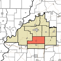
Union Township is one of ten townships in Gibson County, Indiana. As of the 2020 census, its population was 4,399 (up from 4,197 at 2010[3]) and it contained 1,938 housing units,[4] more than 90% of which live either within or in areas adjacent to the town of Fort Branch. Fort Branch is the township seat. Nearly all of the Toyota Motor Manufacturing Indiana Complex is located within Union Township.
Union Township Gibson County | |
|---|---|
 Location of Union Township within Gibson County | |
| Coordinates: 38°14′47″N 87°33′19″W / 38.24639°N 87.55528°W | |
| Country | United States |
| State | Indiana |
| County | Gibson |
| Township Seat | Fort Branch |
| School District | South Gibson School Corporation |
| Named for | The Union |
| Government | |
| • Type | Indiana township |
| • Trustee | Brenda Sollman |
| Area | |
• Total | 50.43 sq mi (130.6 km2) |
| • Land | 50.31 sq mi (130.3 km2) |
| • Water | 0.12 sq mi (0.3 km2) |
| Elevation | 456 ft (139 m) |
| Population (2020) | |
• Total | 4,399 |
| • Density | 87/sq mi (34/km2) |
| Time zone | UTC-6 (CST) |
| • Summer (DST) | UTC-5 (CDT) |
| ZIP code | 47648 |
| Area code | 812 |
| FIPS code | 18-77300[2] |
| GNIS feature ID | 453916 |
Union Township was established in 1890.[5]
| Census | Pop. | Note | %± |
|---|---|---|---|
| 1900 | 2,149 | — | |
| 1910 | 2,507 | 16.7% | |
| 1920 | 2,519 | 0.5% | |
| 1930 | 2,378 | −5.6% | |
| 1940 | 2,707 | 13.8% | |
| 1950 | 3,192 | 17.9% | |
| 1960 | 3,529 | 10.6% | |
| 1970 | 3,788 | 7.3% | |
| 1980 | 4,197 | 10.8% | |
| 1990 | 4,031 | −4.0% | |
| 2000 | 3,954 | −1.9% | |
| 2010 | 4,197 | 6.1% | |
| 2020 | 4,399 | 4.8% | |
| Source: US Decennial Census[6] | |||
Geography
editAccording to the 2010 census, the township has a total area of 50.43 square miles (130.6 km2), of which 50.31 square miles (130.3 km2) (or 99.76%) is land and 0.12 square miles (0.31 km2) (or 0.24%) is water.[3]
Cities and towns
editUnincorporated towns
edit- Durham (extinct)
- Fort Gibson (extinct)
- Snake Run
Adjacent townships
edit- Patoka Township (north)
- Center Township (northeast)
- Barton Township (east)
- Johnson Township (south)
- Montgomery Township (west)
Cemeteries
editThe township contains three cemeteries: Durham, Mount Mariah and Walnut Hill.
Major highways
edit- Interstate 69; Traverses the southeastern corner of the township
- U.S. Route 41; Bisects the township from south to north
- State Road 168; bisects the township from west to east.
Education
editUnion Township is the center of the South Gibson School Corporation.
Public schools
edit- Fort Branch Community School
- Gibson Southern High School
Higher Education
edit- Vincennes University Advanced Manufacturing Campus
Private schools
edit- Holy Cross Catholic Academy - Fort Branch
References
edit- ^ "US Board on Geographic Names". United States Geological Survey. October 25, 2007. Retrieved January 31, 2008.
- ^ "U.S. Census website". United States Census Bureau. Retrieved January 31, 2008.
- ^ a b "Population, Housing Units, Area, and Density: 2010 - County -- County Subdivision and Place -- 2010 Census Summary File 1". United States Census. Archived from the original on February 10, 2020. Retrieved May 10, 2013.
- ^ "Explore Census Data". data.census.gov. Retrieved April 9, 2024.
- ^ Stormont, Gil R. (1914). History of Gibson County, Indiana: Her People, Industries and Institutions. B.F. Bowen. pp. 353.
- ^ "Township Census Counts: STATS Indiana".