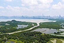
Tsim Bei Tsui (Chinese: 尖鼻咀; lit. 'nose-tip headland') is an area of Yuen Long District in the northwestern part of the New Territories in Hong Kong, facing Deep Bay.[1]


Geography
editThe area is the estuary of the Tin Shui Wai, Shan Pui and Kam Tin rivers.[1]
Kwai Shan (Chinese: 龜山; lit. 'Turtle Hill') is a 71 m high hill located in Tsim Bei Tsui and named after its shape.[1]
Conservation
editTwo parts of Tsim Bei Tsui were designated as Sites of Special Scientific Interest in 1985 and 1989 respectively.[2] The first one features mangrove. It has an area of 2.5 ha and is located along the seafront.[3] The second one, referred to as the 'Tsim Bei Tsui Egretry', has an area of 4.8 ha and features two feng shui groves. It is located south of Tsim Bei Tsui and east of Mong Tseng Wai.[4]
See also
editReferences
edit- ^ a b c Cheung, Sidney C.H. (April 2016). "Wetland in four seasons" (PDF). Hong Kong Discovery. 93: 62.
- ^ "Register of Sites of Special Scientific Interest (SSSIs)". Planning Department.
- ^ "Site of Special Scientific Interest - Tsim Bei Tsui" (PDF). Planning Department. 30 September 1992.
- ^ "Site of Special Scientific Interest - Tsim Bei Tsui Egretry" (PDF). Planning Department. 30 September 1992.
22°29′06″N 114°00′36″E / 22.485°N 114.01°E