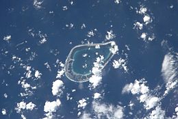
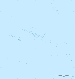
Tenarunga or Tenania, previously Narunga[2] and formerly Minto Island,[3] is a low, wooded atoll in the Acteon Group in the southeastern part of the Tuamotu Islands in French Polynesia. It is administratively a part of the Gambier Islands. The atoll has a population of between 10 and 50 people.[1]
 NASA picture of Tenarunga Atoll | |
| Geography | |
|---|---|
| Location | Pacific Ocean |
| Coordinates | 21°19′S 136°32′W / 21.317°S 136.533°W |
| Archipelago | Tuamotus |
| Area | 5 km2 (1.9 sq mi) (lagoon) 2.3 km2 (0.9 sq mi) (above water) |
| Administration | |
France | |
| Overseas collectivity | French Polynesia |
| Administrative subdivision | Îles Tuamotu-Gambier |
| Commune | Gambier |
| Demographics | |
| Population | 10-50[1] (2022) |

Geography
editTenarunga is located 15 kilometres (9 miles) northwest of Matureivavao, 6 kilometres (4 miles) west of Vahanga and 1,375 kilometres (854 miles) southeast of Tahiti. It has a land area of 2.3 square kilometres (0.9 square miles) and a total area (lagoon inclusive) of 5 square kilometres (2 square miles). There are some buildings and a dock located on the north-east side of the island, indicating former and/or seasonal habitation.
The atoll's lagoon is not accessible from the sea.
History
editThe first recorded sighting of this atoll was made during the Spanish expedition of the Portuguese navigator Pedro Fernández de Quirós on 5 February 1606 under the name Las Cuatro Coronadas (the "four crowned" (by coconut palms));[4][5] however, these observations were not fully documented. As such, the first unambiguous approach to the island was made on 14 March 1828 by the collector Hugh Cuming in his ship The Discoverer, captained by Samuel Grimwood. The next visit was in 1833 by the navigator Thomas Ebrill on his merchant's vessel Amphitrite and again in 1837 by Lord Edward Russell, commander of the H.M.S Actaeon, the name given to the group.[6][7]
Flora and fauna
editThe island is home to many rare species including the Tuamotu sandpiper.[8]
In 2015 a conservation campaign resulted in the eradication of rats from the island.[9]
See also
editReferences
edit- ^ a b "Population". Institut de la statistique de la Polynésie française. Retrieved 23 September 2014.
- ^ "Relation: Tenarunga (1847368)". OpenStreetMap. Retrieved 4 July 2019.
- ^ Quanchi, Max; Robson, John (2005). Historical Dictionary of the Discovery and Exploration of the Pacific Islands. Scarecrow. p. xxiii. ISBN 9780810865280. Retrieved 4 July 2019.
- ^ Brand, Donald D. The Pacific Basin: A History of its Geographical Explorations The American Geographical Society, New York, 1967, p.136.
- ^ Kelly, Celsus, O.F.M. La Austrialia del Espiritu Santo. The Journal of Fray Martín de Munilla O.F.M. and other documents relating to the Voyage of Pedro Fernández de Quirós to the South Sea (1605-1606) and the Franciscan Missionary Plan (1617-1627) Cambridge, 1966, p.39,62.
- ^ Pacific Island: Eastern-Pacific - Geographical handbook series, James Wightman Davidson and Naval Intelligence Division, editions Naval Intelligence Division, 1945, p.224.
- ^ Archaeology of Mangareva and neighboring atolls by Kenneth Pike Emory, editions Kraus, 1971, p.58-60.
- ^ Dahl, prepared by the International Union for Conservation of Nature and Natural Resources, Commission on National Parks and Protected Areas ; in collaboration with the United Nations Environment Programme ; based on the work of Arthur Lyon (1986). Review of the protected areas system in Oceania (Sept. 1986. ed.). Gland, Switzerland: IUCN. ISBN 9782880325091.
{{cite book}}: CS1 maint: multiple names: authors list (link) - ^ "Deux ans après, la dératisation des Actéon-Gambier est un succès" (in French). Tahiti Infos. 11 August 2017. Retrieved 19 December 2022.
- Sailing Directions, Pub 126, "Pacific Islands" NIMA 2002; page-12
External links
edit- Atoll list (in French)
- Google Maps
- Island Conservation: Acteon and Gambier Archipelagos Restoration Project
