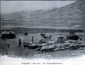
Tegermansu Pass or Tigarman Su Pass (Kotal-e Tegermansu, Chinese: 托克满苏山口[1]) is a closed mountain pass on the border between Afghanistan and China in Wakhan Corridor, in the Hindu Kush — Pamir mountain range.[2] It is located between the Tegermansu Valley on the eastern end of the Little Pamir and Chalachigu Valley in Xinjiang, China. Historically, it was one of the three routes between China and Wakhan.[3]
| Tegermansu Pass | |
|---|---|
 Kyrgyz camp near Tegermansu Pass as captured by Aurel Stein | |
| Elevation | 4,827 metres (15,837 ft) |
| Location | Wakhan, Badakhshan, Afghanistan - Taxkorgan, Kashgar, Xinjiang, China |
| Range | Pamir Mountains |
| Coordinates | 37°17′04″N 74°44′01″E / 37.2844°N 74.7336°E |
 | |
| Tegermansu Pass | |||||||
|---|---|---|---|---|---|---|---|
| Traditional Chinese | 托克滿蘇達坂 | ||||||
| Simplified Chinese | 托克满苏达板 | ||||||
| |||||||
| Tok Man Su Daban | |||||||
| Traditional Chinese | 托克滿素達坂 | ||||||
| Simplified Chinese | 托克满素达坂 | ||||||
| |||||||
| Tigarman Su Pass | |||||||
| Traditional Chinese | 鐵蓋滿蘇山口 | ||||||
| Simplified Chinese | 铁盖满苏山口 | ||||||
| |||||||
On Chinese side, there is a Chinese border post in the valley below.[4] There have been proposals and plans by Kashgar regional government to open this pass as a port of entry for economic purposes since the 1990s.[5][6] However, this has yet to happen.
Tegerman Su is the name of the river valley on the Afghan side, easternmost part of Afghanistan.[7] During the late 2000s, due to lawlessness, the Kirghiz in Afghanistan reported robbery and theft in Little Pamir by bandits from Tajikistan.[7]
-
Stylized horse and bird, Tomb of Tegermansu I, Eastern Pamirs, Tajikistan, 4th century BCE
-
Map of Afghanistan-China Boundary including Tegermansu Pass (labeled as TĪGARMAN SŪ DAVĀN) (1969)[a]
See also
editNotes
edit- ^ From map: "NAMES AND BOUNDARY REPRESENTATION ARE NOT NECESSARILY AUTHORITATIVE"
References
edit- ^ [Afghanistan-China Border Agreement] (in Chinese). 1963-11-22 – via Wikisource.
托克满素达坂(阿方图称米赫满育里山口)...克克拉去考勒达坂(阿方图称铁盖满苏山口)
- ^ "Wakhan & the Afghan Pamir - In the footsteps of Marco Polo". Aga Khan Foundation. Jan 2010.
side trip to Tegermansu (3-4 days one way from Chaqmaqtin Lake) and Kotal-e Tegermansu (4872m) on Afghanistan-China border, easternmost area of Little Pamir. Warning: All passes leading into Tajikistan and China are strictly off-limits to foreigners
- ^ Malik, Hasan Yaser (2014). "Geo-political Significance of the Wakhan Corridor for China". Fudan Journal of the Humanities and Social Sciences. 7 (2): 307–323. doi:10.1007/s40647-014-0017-z. ISSN 1674-0750. S2CID 140705773.
The narrow Wakhan Strip provides the following three routes -- The third one is the Central Route: linking both the Northern and Southern routes at Wakhan and further leading to China via Tegermansu Pass over a height of 4,827 m.
- ^ "蜀中行:"瓦罕走廊"传来重大消息,阿富汗向中国送上大礼!-中华必亮剑天天时事-中华必亮剑个人博客". m.bljcn.com (in Chinese). 2018-08-31. Retrieved 23 December 2019.
托克满苏边防站 如今的瓦罕走廊驻守着明铁盖边防7连、托克满苏边防8连、克克吐鲁克(科克吐鲁克)边防9连。
- ^ "新疆对外开放口岸一览表". china.com.cn (in Chinese). Retrieved 23 December 2019.
国别:阿富汗 口岸名称:托克满苏 开放时间:未定 说明:规划开放口岸(98年) Country: Afghanistan, Name of port: Tegermansu, Opening date: Undecided, Notes: Planning to open the port (1998)
- ^ 喀什地区发展和改革委员会 (Kashgar Region Development and Reform Committee) (2016-03-17). "喀什地区国民经济和社会发展第十三个五年" [Kashgar Regional Economic and Social Development 13th Five-Year Plan (2016-2020)]. Retrieved 23 December 2019.
推进新建中国-阿富汗托克满苏陆路口岸、中国-巴基斯坦铁路口岸、中国-塔吉克斯坦铁路口岸。改善现有口岸通关条件。
- ^ a b Tofel, Bartek (2010). "Tegerman Su Valley and Eastern Sector Aq Su Valley (Little Pamir), Exploration". American Alpine Journal. pp. 253–255. Retrieved 12 March 2022.
It took nine days to reach the easternmost part of the Wakhan Corridor and Afghanistan—the Tegerman Su Valley. ... Tegerman Su is a sensitive area: Kirghiz report the possibility of robbery by neighboring Tajiks. ... the Kirghiz did tell me about Tajik bandits stealing their animals at night.


![Map of Afghanistan-China Boundary including Tegermansu Pass (labeled as TĪGARMAN SŪ DAVĀN) (1969)[a]](http://up.wiki.x.io/wikipedia/commons/thumb/4/4c/Afghanistan-China_Boundary._4-69._LOC_gm70003373_cropped.jpg/200px-Afghanistan-China_Boundary._4-69._LOC_gm70003373_cropped.jpg)