Tavurvur is an active stratovolcano near Rabaul, on the island of New Britain, in Papua New Guinea. It is a sub-vent of the Rabaul caldera[1] and lies on the eastern rim of the larger feature. An eruption of the volcano largely destroyed the nearby town of Rabaul in 1994.
| Tavurvur | |
|---|---|
 Tavurvur erupting | |
| Highest point | |
| Elevation | 688 m (2,257 ft)[1] |
| Coordinates | 4°14′20″S 152°12′36″E / 4.239°S 152.21°E |
| Geography | |
 Tavurvur | |
| Geology | |
| Mountain type | Cinder Cone volcano, vent of Rabaul caldera |
| Last eruption | August to September 2014[1] |
Mount Tavurvur is the most active volcano in Rabaul caldera, and erupted most recently on 29 August 2014.[2]
The correct pronunciation of the volcano's name is tah-VOOR-voor, according to the Rabaul Volcanological Observatory.[citation needed]
History
editGallery
edit-
 Space Radar Image of Rabaul Volcano
 -
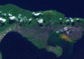 Tavurvur from Low Earth orbit
 -
 Tavurvur's 2009 eruption
 -
 Ash plume from Tavurvur
 -


References
edit- ^ a b c "Rabaul". Global Volcanism Program. Smithsonian Institution. Retrieved 2020-03-25.
- ^ "Rabaul (Tavurvur) volcano (New Britain, Papua New Guinea) activity update". volcanodiscovery.com. 2014-09-12. Retrieved 2014-11-11.
External links
editWikimedia Commons has media related to Tavurvur volcano.
- Volcano World: Tavurvur, Rabaul Caldera
- Volcano Eruption in Papua New Guinea on YouTube, the August 29th, 2014 eruption of Tavurvur captured by Phil McNamara.