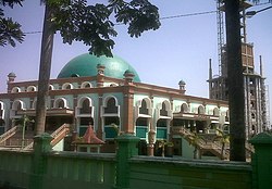
Sumber (Sundanese: ᮞᮥᮙ᮪ᮘᮨᮁ; Javanese: ꦯꦸꦩ꧀ꦧꦺꦂ) is a district which serves as the regency seat of the Cirebon Regency of West Java, Indonesia. It is divided into 14 villages which are listed as follows (with their populations as at mid 2022):[3]
Sumber | |
|---|---|
| Regional transcription(s) | |
| • Sundanese | ᮞᮥᮙ᮪ᮘᮨᮁ |
| • Javanese | ꦯꦸꦩ꧀ꦧꦺꦂ |
 Grand Mosque of Sumber | |
| Coordinates: 6°45′16″S 108°29′9″E / 6.75444°S 108.48583°E | |
| Country | |
| Province | West Java |
| Regency | Cirebon Regency |
| Government | |
| • Camat | Iman Santoso |
| • Secretary | Carmin |
| Area | |
| • Total | 25.65 km2 (9.90 sq mi) |
| Elevation | 66 m (217 ft) |
| Population (mid 2023 estimate)[2] | |
| • Total | 102,973 |
| • Density | 4,000/km2 (10,000/sq mi) |
| Time zone | UTC+7 (IWT) |
| Postal code | 4561x |
| Area code | (+62) 231 |
| Villages | 14 |
| Website | Official website |
- Babakan (4,368)
- Sumber (10,496)
- Perbutulan (4,786)
- Kaliwadas (9,646)
- Pasalakan (9,333)
- Watubelah (8,134)
- Pejambon (5,111)
- Gegunung (5,671)
- Kemantren (5,160)
- Sendang (4,775)
- Tukmudal (13,876)
- Kenanga (8,652)
- Matangaji (4,988)
- Sidawangi (6,659)
The first 12 of these 14 are classed as urban kelurahan (Babakan occupying 1.38 km2, Sumber 2.50 km2, Perbutulan 0.53 km2, Kaliwadas 1.76 km2, Pasalakan 1.62 km2, Watubelah 1.93 km2, Pejambon 1.44 km2, Gegunung 1.72 km2, Kemantren 0.75 km2, Sendang 0.74 km2, Tukmudal 2.30 km2 and Kenanga 1.86 km2), while the remaining 2 are classed as rural desa and are situated in the south of the district (Matangaji with an area of 2.48 km2 and Sidawangi 4.64 km2).
Climate
editSumber has a tropical monsoon climate (Am) with moderate to little rainfall from June to October and heavy to very heavy rainfall from November to May.
| Climate data for Sumber | |||||||||||||
|---|---|---|---|---|---|---|---|---|---|---|---|---|---|
| Month | Jan | Feb | Mar | Apr | May | Jun | Jul | Aug | Sep | Oct | Nov | Dec | Year |
| Mean daily maximum °C (°F) | 30.9 (87.6) |
30.7 (87.3) |
31.2 (88.2) |
31.7 (89.1) |
32.0 (89.6) |
32.0 (89.6) |
32.1 (89.8) |
32.6 (90.7) |
33.3 (91.9) |
33.6 (92.5) |
32.5 (90.5) |
31.6 (88.9) |
32.0 (89.6) |
| Daily mean °C (°F) | 26.6 (79.9) |
26.4 (79.5) |
26.7 (80.1) |
27.1 (80.8) |
27.3 (81.1) |
27.0 (80.6) |
27.0 (80.6) |
27.1 (80.8) |
27.5 (81.5) |
27.9 (82.2) |
27.4 (81.3) |
26.9 (80.4) |
27.1 (80.7) |
| Mean daily minimum °C (°F) | 22.3 (72.1) |
22.2 (72.0) |
22.3 (72.1) |
22.5 (72.5) |
22.6 (72.7) |
22.0 (71.6) |
21.9 (71.4) |
21.6 (70.9) |
21.7 (71.1) |
22.2 (72.0) |
22.4 (72.3) |
23.3 (73.9) |
22.3 (72.1) |
| Average rainfall mm (inches) | 499 (19.6) |
416 (16.4) |
412 (16.2) |
218 (8.6) |
157 (6.2) |
80 (3.1) |
61 (2.4) |
44 (1.7) |
29 (1.1) |
73 (2.9) |
226 (8.9) |
360 (14.2) |
2,575 (101.3) |
| Source: Climate-Data.org[4] | |||||||||||||
References
edit- ^ a b "Sumber District in Figures 2020". Statistics Indonesia. Retrieved December 9, 2020.
- ^ BPS Kabupaten Cirebon 2024.
- ^ BPS Kecamatan Sumber 2023.
- ^ "Climate: Sumber". Climate-Data.org. Retrieved 12 November 2020.

