The Spatsizi River is a tributary of the Stikine River, rising near Mount Gunanoot in the southeastern Spatsizi Plateau, British Columbia.
| Spatsizi River | |
|---|---|
 | |
| Physical characteristics | |
| Source | Mount Gunanoot |
| • location | Near Spatsizi Headwaters Provincial Park |
| • elevation | 1,900 m (6,200 ft) |
| Mouth | Stikine River |
• location | Hyland Post |
• coordinates | 57°42′27″N 128°06′11″W / 57.70750°N 128.10306°W[1] |
| Length | 132 km (82 mi)[2] |
| Basin size | 3,516 km2 (1,358 sq mi)[3] |
| Discharge | |
| • average | 60.8 m3/s (2,150 cu ft/s)[3] |
Etymology
edit"Spatsizi" is a phrase from the Sekani language meaning "red goat", a reference to the habit of mountain goats in the region of rolling in the red dust of a particular mountain, making their coat-hair red.
Geography
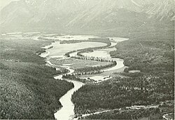
editThe Spatsizi River emerges near the foot of Mount Gunanoot in the Skeena Mountains of north-central British Columbia. It then flows downslope and enters Spatsizi Headwaters Provincial Park from the south. The river continues north, leaving the park to enter a broad valley in the heart of the Spatsizi Plateau. The flat-bottomed topography of the valley allows the river to meander considerably along much of its northwestward flow until it reaches the Stikine River in Stikine River Provincial Park.[4]
See also
editReferences
edit- ^ "Spatsizi River". BC Geographical Names. Retrieved 2022-06-26.
- ^ Lehner, B., Verdin, K., Jarvis, A. (2008): New global hydrography derived from spaceborne elevation data. Eos, Transactions, AGU, 89(10): 93–94.
- ^ a b "Northwest Water Tool". BC Water Tool. GeoBC, Integrated Land Management Bureau, Ministry of Agriculture and Lands, Government of British Columbia. Retrieved 2022-06-26.
- ^ "Management Direction Statement for Spatsizi Headwaters Provincial Park" (PDF). bcparks.ca. 2003-03-01. Retrieved 2020-10-23.
