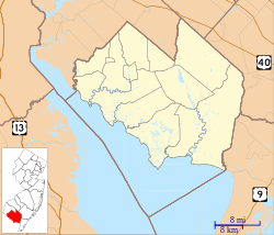
Silver Lake is a census-designated place (CDP) in Cumberland County, in the U.S. state of New Jersey. It is in the northern part of the county, in the southwest part of Upper Deerfield Township. It is bordered to the west by the Cohansey River, which forms the boundary with Hopewell Township, to the north by Seeley, and to the south by Sunset Lake. Bridgeton, the Cumberland county seat, is 3 miles (5 km) to the south.
Silver Lake, New Jersey | |
|---|---|
Location in Cumberland County Location in New Jersey | |
| Coordinates: 39°28′1″N 75°14′28″W / 39.46694°N 75.24111°W | |
| Country | |
| State | |
| County | Cumberland |
| Township | Upper Deerfield |
| Area | |
• Total | 1.45 sq mi (3.74 km2) |
| • Land | 1.43 sq mi (3.71 km2) |
| • Water | 0.01 sq mi (0.04 km2) |
| Elevation | 72 ft (22 m) |
| Population | |
• Total | 1,435 |
| • Density | 1,002.80/sq mi (387.30/km2) |
| Time zone | UTC−05:00 (Eastern (EST)) |
| • Summer (DST) | UTC−04:00 (EDT) |
| ZIP Code | 08302 (Bridgeton) |
| Area code | 856 |
| FIPS code | 34-67583[3] |
| GNIS feature ID | 2812755[4] |
Silver Lake was first listed as a CDP prior to the 2020 census.[4]
Demographics
edit| Census | Pop. | Note | %± |
|---|---|---|---|
| 2020 | 1,435 | — | |
| U.S. Decennial Census[5][2] | |||
References
edit- ^ "ArcGIS REST Services Directory". United States Census Bureau. Retrieved October 11, 2022.
- ^ a b "Census Population API". United States Census Bureau. Retrieved October 11, 2022.
- ^ Geographic Codes Lookup for New Jersey, Missouri Census Data Center. Accessed June 9, 2023.
- ^ a b "Silver Lake Census Designated Place". Geographic Names Information System. United States Geological Survey, United States Department of the Interior.
- ^ "Census of Population and Housing". Census.gov. Retrieved June 4, 2016.


