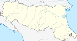
Sestola (Sestolese: Sèstula; Frignanese: Sèstla) is a comune (municipality) in the province of Modena, in the Italian region of Emilia-Romagna, located about 60 kilometres (37 mi) southwest of Bologna and about 50 kilometres (31 mi) southwest of Modena. It is located near the Monte Cimone and other mountains of the northern Apennines separating Emilia and Tuscany.
Sestola | |
|---|---|
| Comune di Sestola | |
 | |
| Coordinates: 44°14′N 10°46′E / 44.233°N 10.767°E | |
| Country | Italy |
| Region | Emilia-Romagna |
| Province | Modena (MO) |
| Frazioni | Casine, Castellaro, Rocchetta Sandri, Roncoscaglia, Vesale |
| Government | |
| • Mayor | chiara cappi |
| Area | |
• Total | 52.47 km2 (20.26 sq mi) |
| Elevation | 1,020 m (3,350 ft) |
| Population (31 December 2014)[2] | |
• Total | 2,500 |
| • Density | 48/km2 (120/sq mi) |
| Demonym | Sestolesi |
| Time zone | UTC+1 (CET) |
| • Summer (DST) | UTC+2 (CEST) |
| Postal code | 41029 |
| Dialing code | 0536 |
| Website | Official website |
Sestola borders the following municipalities: Fanano, Fiumalbo, Lizzano in Belvedere, Montecreto, Montese, Pavullo nel Frignano, Riolunato.
Main sights
edit- Fortress, rebuilt in the 16th century but dating to several centuries before.
- Giardino Botanico Alpino "Esperia"
- San Nicola di Bari church
Climate
edit| Climate data for Sestola (1991–2020) | |||||||||||||
|---|---|---|---|---|---|---|---|---|---|---|---|---|---|
| Month | Jan | Feb | Mar | Apr | May | Jun | Jul | Aug | Sep | Oct | Nov | Dec | Year |
| Mean daily maximum °C (°F) | 4.8 (40.6) |
5.8 (42.4) |
9.7 (49.5) |
12.7 (54.9) |
18.1 (64.6) |
22.0 (71.6) |
25.1 (77.2) |
24.9 (76.8) |
19.4 (66.9) |
14.0 (57.2) |
9.0 (48.2) |
5.1 (41.2) |
14.2 (57.6) |
| Daily mean °C (°F) | 2.0 (35.6) |
2.4 (36.3) |
5.9 (42.6) |
8.9 (48.0) |
13.8 (56.8) |
17.7 (63.9) |
20.5 (68.9) |
20.5 (68.9) |
15.5 (59.9) |
10.9 (51.6) |
6.3 (43.3) |
2.6 (36.7) |
10.6 (51.0) |
| Mean daily minimum °C (°F) | −0.9 (30.4) |
−1.1 (30.0) |
2.1 (35.8) |
5.1 (41.2) |
9.5 (49.1) |
13.4 (56.1) |
15.9 (60.6) |
16.0 (60.8) |
11.6 (52.9) |
7.8 (46.0) |
3.5 (38.3) |
0.1 (32.2) |
6.9 (44.4) |
| Average precipitation mm (inches) | 105 (4.1) |
107 (4.2) |
111 (4.4) |
144 (5.7) |
113 (4.4) |
99 (3.9) |
68 (2.7) |
89 (3.5) |
118 (4.6) |
163 (6.4) |
180 (7.1) |
133 (5.2) |
1,430 (56.2) |
| Average precipitation days (≥ 1.0 mm) | 9 | 8 | 9 | 11 | 10 | 8 | 5 | 6 | 8 | 10 | 13 | 10 | 107 |
| Source 1: Istituto Superiore per la Protezione e la Ricerca Ambientale (precipitation 1951–1980)[3][4] | |||||||||||||
| Source 2: Climi e viaggi (precipitation days)[5] | |||||||||||||
See also
editReferences
edit- ^ "Superficie di Comuni Province e Regioni italiane al 9 ottobre 2011". Italian National Institute of Statistics. Retrieved 16 March 2019.
- ^ All demographics and other statistics: Italian statistical institute Istat.
- ^ "Valori climatici normali in Italia". Istituto Superiore per la Protezione e la Ricerca Ambientale. Archived from the original on 17 September 2023. Retrieved 26 November 2024.
- ^ "Valori climatici normali di temperatura e precipitazione in Italia" (PDF). Istituto Superiore per la Protezione e la Ricerca Ambientale. Retrieved 28 November 2024.
- ^ "Clima - Rieti (Lazio)". Climi e viaggi. Retrieved 28 November 2024.


