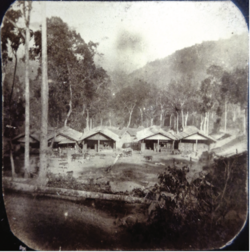
Sairang is a town in the Aizawl district of the Indian state of Mizoram. Due to its proximity with Aizawl city, it acts as a satellite town of the city.
Sairang | |
|---|---|
Town | |
 Sairang Bazaar in 1896 | |
| Coordinates: 23°48′N 92°40′E / 23.8°N 92.67°E | |
| Country | India |
| State | Mizoram |
| District | Aizawl |
| Elevation | 210 m (690 ft) |
| Population (2001) | |
• Total | 5,036 |
| Languages | |
| • Official | Mizo |
| Time zone | UTC+5:30 (IST) |
| Vehicle registration | MZ |
| Climate | Aw |
| Website | mizoram |
History
editAfter the British invasion of 1871-1872, Bengali traders set up the first market place in Mizoram in Changsil[1]
Sairang is the nearest town with river from Aizawl which is about 14 kilometers. The journey of about 140 Kilometers from Sairang to Silchar via Tlawng river used to take about 15–30 days during the 1890s depending upon the season and water level on a flat water boat.[2]
Geography
editSairang is located at 23°48′N 92°40′E / 23.8°N 92.67°E.[3]
Connectivity
editSairang lies on the route of Kaladan Multi-Modal Transit Transport Project. It is connected with roads from major towns in Assam, through NH 54. The nearest railway station is at Bairabi, which is connected to the railway network with a broad gauge track. A new broad gauge line from Bairabi to Sairang is under construction.[4] Due to several delays in construction work, and due to COVID-19 pandemic-related lockdowns and lack of labour, the revised deadline of the rail line to Sairang, and the final extension till Mizoram's capital Aizawl, is likely to be completed by March 2023.[5]
Survey for the Rail line from Sairang to Hmawngbuchhuah on border near Zorinpui was completed in August 2017 and it will be constructed in future phase.[6]
100 kilometres (62 mi) route from Indo-Myanmar border at Zorinpui to Aizawl is upgraded to two-lane in both directions (total 4 lanes). From Aizal it connect to Aizawal-Saiha National Highway at Lawngtlai in Mizoram in India by road on National Highway 54 (India) (NH-54), which then continues further to Dabaka in Assam via 850 km long NH-54 which in turn is part of the larger East-West Corridor connecting North East India with the rest of India.[7] Almost complete (June 2017).[8] Tender has been awarded, upgrade to this national highway is under-construction and to be Completed by 2019.[9]
Demographics
editAs of the 2011 Census of India, Sairang had a population of 5,950.[10]
References
edit- ^ Chaterjee, Suhas. Mizo Chiefs and the Chiefdom. p. 12.
- ^ Pachuau, Joy (13 April 2015). The Camera as a Witness. Cambridge. pp. 149–150, 161, 169. ISBN 9781107073395.
- ^ Falling Rain Genomics, Inc - Sairang
- ^ Sanctioned in 2000, broad-gauge train reaches Mizoram after 16 years Indian Express, Retrieved 21 March 2016.
- ^ Indian Railways to complete Bairabi–Sairang railway line project by 2023, railway-technology.com, 15 Feb 2021.
- ^ India's north east opened up, PowerUpConstruction.Com
- ^ Multi-modal route map
- ^ India awards road contract to complete Kaladan project in Myanmar, Business Line, 9 June 2017.
- ^ Still under construction, The Statesman, 13 May 2018.
- ^ "Census of India: Search Details - Sairang". Retrieved 10 November 2021.

