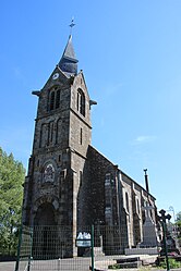
Saint-Georges-d'Annebecq (French pronunciation: [sɛ̃ ʒɔʁʒ danbɛk] ⓘ) is a commune in the Orne department in Normandy (north-western France).[3]
Saint-Georges-d'Annebecq | |
|---|---|
 The church in Saint-Georges-d'Annebecq | |
| Coordinates: 48°38′02″N 0°15′50″W / 48.6339°N 0.2639°W | |
| Country | France |
| Region | Normandy |
| Department | Orne |
| Arrondissement | Argentan |
| Canton | Magny-le-Désert |
| Intercommunality | Terres d'Argentan Interco |
| Government | |
| • Mayor (2020–2026) | Aurélien Baudoux[1] |
Area 1 | 9.35 km2 (3.61 sq mi) |
| Population (2022)[2] | 167 |
| • Density | 18/km2 (46/sq mi) |
| Time zone | UTC+01:00 (CET) |
| • Summer (DST) | UTC+02:00 (CEST) |
| INSEE/Postal code | 61390 /61600 |
| Elevation | 213–292 m (699–958 ft) (avg. 232 m or 761 ft) |
| 1 French Land Register data, which excludes lakes, ponds, glaciers > 1 km2 (0.386 sq mi or 247 acres) and river estuaries. | |
Geography
editThe commune is made up of the following collection of villages and hamlets, Annebecq,La Métairie, La Chauvinière, Le Clos Léger, Le Bissonnu, Le Bois Tesselin and Saint-Georges-d'Annebecq.[4]
It is 940 hectares (3.6 sq mi) in size. The highest point in the commune is 225 metres (738 ft).
There are a total of four watercourses that flow through the communes borders, The Rouvre river plus three streams The Beaudouit, The Bois Tesselin and the Masses.
See also
editReferences
edit- ^ "Répertoire national des élus: les maires". data.gouv.fr, Plateforme ouverte des données publiques françaises (in French). 9 August 2021.
- ^ "Populations de référence 2022" (in French). The National Institute of Statistics and Economic Studies. 19 December 2024.
- ^ "Commune de Saint-Georges-d'Annebecq (61390)". INSEE.
- ^ a b "Saint-Georges-d'Annebecq · 61600, France". Saint-Georges-d'Annebecq · 61600, France.
Wikimedia Commons has media related to Saint-Georges-d'Annebecq.


