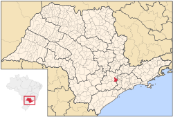
São Roque (meaning Saint Roch in Portuguese) is a city in the state of São Paulo in Brazil. It is part of the Metropolitan Region of Sorocaba.[2] The population is 92,060 (2020 est.) in an area of 306.91 km².[3] The city is at an altitude of 771 m. São Roque is connected by two main highways: Rodovia Raposo Tavares and Rodovia Castelo Branco. It is located 60 km west from the state capital. Some of the neighboring municipalities are Cotia, Vargem Grande Paulista, Ibiúna, Mairinque and Aluminio.
São Roque | |
|---|---|
 Location in São Paulo state | |
| Coordinates: 23°31′45″S 47°08′07″W / 23.52917°S 47.13528°W | |
| Country | Brazil |
| Region | Southeast |
| State | São Paulo |
| Metrop. region | Sorocaba |
| Government | |
| • Mayor | Marcos Augusto Issa Henriques de Araújo (PODE, 2021–2024) |
| Area | |
• Total | 306.91 km2 (118.50 sq mi) |
| Elevation | 771 m (2,530 ft) |
| Population (2020 [1]) | |
• Total | 92,060 |
| • Density | 300/km2 (780/sq mi) |
| Time zone | UTC-03:00 (BRT) |
| • Summer (DST) | UTC-02:00 (BRST) |
| Postal code | 18130-000 |
| Area code | +55 11 |
| Website | www |
São Roque has protected greenspaces and maintains itself as a lush ecological paradise. It has a good climate with a wonderful countryside. The Serra do Mar mountains cover the southeast. It has an excellent infrastructure, especially well-developed for wine production. In the 19th century, immigrants from Italy and Portugal arrived in São Roque to work in vineyards. Tourism is also a significant part of the economy. It holds the largest artificial ski park in Latin America, the Ski Mountain Park.
Media
editIn telecommunications, the city was served by Companhia Telefônica Brasileira until 1973, when it began to be served by Telecomunicações de São Paulo.[4] In July 1998, this company was acquired by Telefónica, which adopted the Vivo brand in 2012.[5]
The company is currently an operator of cell phones, fixed lines, internet (fiber optics/4G) and television (satellite and cable).[5]
Transportation
editThe city is served by São Paulo Catarina Executive Airport.
Persons
edit- Juca de Oliveira, actor
References
edit- ^ IBGE 2020
- ^ "Governo do Estado de São Paulo, Lei Complementar nº 1.241, de 8 de maio de 2014". Archived from the original on 18 October 2014. Retrieved 2015-09-29.
{{cite web}}: CS1 maint: bot: original URL status unknown (link) - ^ Instituto Brasileiro de Geografia e Estatística
- ^ "Creation of Telesp - April 12, 1973". www.imprensaoficial.com.br (in Portuguese). Retrieved 2024-05-27.
- ^ a b "Our History - Telefônica RI". Telefônica. Retrieved 2024-05-27.
External links
edit- (in Portuguese) http://www.guiasaoroque.com.br Website about São Roque
- (in Portuguese) http://www.saoroque.sp.gov.br
- (in Portuguese) São Roque on citybrazil.com.br


