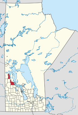
The Rural Municipality of Mountain is a rural municipality (RM) in the Parkland Region of Manitoba, western Canada.
Mountain | |
|---|---|
| Rural Municipality of Mountain | |
 Location of the Rural Municipality of Mountain in Manitoba | |
 | |
| Coordinates: 52°16′27″N 100°36′30″W / 52.27417°N 100.60833°W | |
| Country | Canada |
| Province | Manitoba |
| Region | Parkland |
| Incorporated as an LGD | January 1, 1945 |
| Incorporated as an RM | January 1, 1997 |
| Government | |
| • Reeve | Robert Hanson |
| Area | |
| • Land | 2,607.77 km2 (1,006.87 sq mi) |
| Population (2016) | |
• Total | 978 |
| Website | rmofmountain |
Its 2,607 square kilometres (1,007 sq mi) is split geographically into two large sections—Mountain (North) at 52°34′48″N 101°00′54″W / 52.58000°N 101.01500°W, and Mountain (South) at 51°58′21″N 100°23′31″W / 51.97250°N 100.39194°W—separated by approximately 10 km (6.2 mi) at the northeast corner of Municipality of Minitonas – Bowsman.[1]
The municipality, which was named for the nearby Porcupine and Duck Mountains,[2] sits along the east side of both the Porcupine Provincial Forest in the north and the Duck Mountain Provincial Forest in the south.[1]
Its largest communities are the local urban districts of Pine River, Birch River, and Mafeking.[1]
Communities
editThe constituent communities of the Rural Municipality of Mountain include the following.[1][3][2]
Mountain (South):[1]
Mountain (North):[1]
Demographics
edit- North part
In the 2021 Census of Population conducted by Statistics Canada, the north portion of the RM of Mountain had a population of 537 living in 257 of its 297 total private dwellings, a change of -3.9% from its 2016 population of 559. With a land area of 988.01 km2 (381.47 sq mi), it had a population density of 0.5/km2 (1.4/sq mi) in 2021.[4]
- South part
In the 2021 Census of Population conducted by Statistics Canada, the south portion of the RM of Mountain had a population of 443 living in 187 of its 250 total private dwellings, a change of 5.7% from its 2016 population of 419. With a land area of 1,615.42 km2 (623.72 sq mi), it had a population density of 0.3/km2 (0.7/sq mi) in 2021.[4]
- Combined
In the 2021 Census of Population conducted by Statistics Canada, the RM of Mountain had a combined population of 980 living in 444 of its 547 total private dwellings, a change of 0.2% from its 2016 population of 978. With a land area of 2,603.43 km2 (1,005.19 sq mi), it had a population density of 0.4/km2 (1.0/sq mi) in 2021.[4]
References
edit- ^ a b c d e f "History". RM of Mountain. Retrieved August 5, 2021.
- ^ a b "Manitoba Communities: Mountain (Rural Municipality)". www.mhs.mb.ca. Retrieved August 5, 2021.
- ^ "Home". RM of Mountain. Retrieved August 5, 2021.
- ^ a b c "Population and dwelling counts: Canada, provinces and territories, and census subdivisions (municipalities), Manitoba". Statistics Canada. February 9, 2022. Retrieved February 20, 2022.