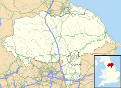
Romanby is a village and civil parish in North Yorkshire, England. Romanby is situated south-west of and contiguous with Northallerton, and at the 2001 UK census had a population of 6,051, increasing to 6,177 at the 2011 Census.[1]
| Romanby | |
|---|---|
 Packhorse bridge across Willow Beck | |
Location within North Yorkshire | |
| Population | 6,177 (2011 census)[1] |
| OS grid reference | SE361927 |
| Unitary authority | |
| Ceremonial county | |
| Region | |
| Country | England |
| Sovereign state | United Kingdom |
| Post town | Northallerton |
| Postcode district | DL7 |
| Dialling code | 01609 |
| Police | North Yorkshire |
| Fire | North Yorkshire |
| Ambulance | Yorkshire |
| UK Parliament | |
History
editThe name Romanby suggests that the village dates from Roman times, but derives from the Viking name Hromund.[2] The village was mentioned in the Domesday Book as belonging to King William.[3]
Romanby chapel, which dated from the 13th century, was demolished in 1523 on the orders of the Bishop of Durham, Thomas Wolsey.[4] Its destruction was ordered because the vicar of Northallerton at the time, had questioned the bishop's authority.[5] St James' Church was built in 1882. It is a grade II listed structure.[6] Romanby Methodist Church dates from 1962.[7]
Geography
editBefore the railway was built, Romanby was separated from Northallerton by a 0.5-mile (0.8 km) strip of pasture land, but since the railway opened, the spread of each settlement means that the two are contiguous.[8] The Wensleydale Railway passes over a bridge on the outskirts of Romanby village on its way to Redmire from Northallerton West railway station. A grade II listed packhorse bridge straddles the Willow Beck.[9][10] Water from the beck powered a water-mill in the village, which was last listed in 1663.[11] The beck flows southwards and enters the River Wiske before the A684 road. The River Wiske formed the western boundary of the old Allertonshire Wapentake.[12]
Governance
editNorth Yorkshire County Council has its headquarters at County Hall in Romanby, on the site of a former a racecourse. It was designed by the York architect Walter Brierley for North Riding County Council. The main building constructed in 1904–14 is of two storeys of ashlar and red brick on a square courtyard plan, it has a 15-bay frontage and 23-bay returns. It is a grade II* listed building.[13]
Romanby electoral ward does not cover all the parish and had a total population at the 2011 Census of 3,946.[14]
Amenities
editThe village has several shops, a post office, a dentist, a hairdressers and a public house, the Golden Lion.[15]
Romanby is served by Romanby Primary School. The local secondary school and sixth form is Northallerton School.
Romanby Golf Course on the village outskirts has an 18-hole course, floodlit driving range and a clubhouse. Northallerton Town Football Club is located in Romanby.
References
edit- ^ a b UK Census (2011). "Local Area Report – Romanby Parish (1170216911)". Nomis. Office for National Statistics. Retrieved 21 May 2018.
- ^ Ekwall, Eilert (1960). The concise Oxford dictionary of English place-names (4 ed.). Oxford: Oxford University Press. p. 392. ISBN 0-19-869103-3.
- ^ "Romanby | Domesday Book". opendomesday.org. Retrieved 15 August 2024.
- ^ Bogg, Edmund (1908). Richmondshire: an account of its history and antiquities, characters and customs, legendary lore, and natural history. London: Elliot Stock. p. 25. OCLC 1385443354.
- ^ Page 1968, p. 432.
- ^ Historic England. "Church of St James the Great (Grade II) (1380322)". National Heritage List for England. Retrieved 15 August 2024.
- ^ "Romanby Parish Council - About Romanby". Romanby Parish Council. Retrieved 26 October 2024.
- ^ Bogg, Edmund (1908). Richmondshire: an account of its history and antiquities, characters and customs, legendary lore, and natural history. London: Elliot Stock. p. 24. OCLC 1385443354.
- ^ Historic England. "Packhorse Bridge (Grade II) (1190645)". National Heritage List for England. Retrieved 15 August 2024.
- ^ "Willow Beck level at Romanby - GOV.UK". check-for-flooding.service.gov.uk. Retrieved 15 August 2024.
- ^ Page 1968, p. 421.
- ^ Page 1968, p. 418.
- ^ Historic England. "COUNTY HALL (1150967)". National Heritage List for England. Retrieved 10 December 2013.
- ^ UK Census (2011). "Local Area Report – Romanby 2011 Census Ward (1237325076)". Nomis. Office for National Statistics. Retrieved 21 May 2018.
- ^ "Romanby Parish Council - About Romanby". romanby-pc.gov.uk. Retrieved 15 August 2024.
