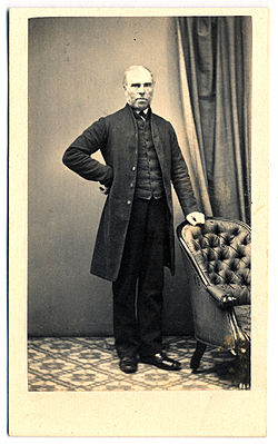
Robert Harald Lindsay Dixon (1800–1858) was an Australian surveyor and explorer, born in Cockfield, County Durham,[2] England.[3] Dixon is credited with having first surveyed and named a number of areas along the East Coast of Australia.
Robert Dixon | |
|---|---|
 Robert Dixon | |
| Born | 1800 Cockfield, County Durham, England |
| Died | 8 April 1858 Sydney, Australia |
| Occupation | Surveyor |
| Spouse | Margaret Sibly |
| Children | 6 (Langford Dangar, Joel and Jerome)[1] |
| Parent(s) | James and Elizabeth |
Surveying expeditions
editIn 1831–32 Dixon carried out surveys in the Upper Hunter and New England districts.[4][5]
Having failed to gain reinstatement, Dixon moved to Moreton Bay. During that year, Dixon, with assistant surveyors Granville Stapylton and James Warner, began a trigonometrical survey of Moreton Bay for the Government to facilitate free settlement.[6] A baseline of 3 miles (4.8 km) was measured on Normanby Plains (today's Harrisville, south of Ipswich) as a foundation for the triangulation. Dixon was instructed to compile a plan of the district for land sales and town reserves.[7][8] This angered Governor Sir George Gipps.[9]
Dixon is credited with having first surveyed and named a number of areas along the East Coast of Australia including:
- Cronulla, New South Wales – the named based on the Aboriginal word kurranulla.
- Gunnamatta Bay, New South Wales.
- The Oaks, New South Wales – and surrounding areas.
- Otford, New South Wales – originally named Bulgo by Dixon.
- Russell Island, Queensland.[8]
- Wellington Point, Queensland.
Legacy
editDixon, Stapylton and Warner are commemorated on a plaque at the Land Centre, Woolloongabba in Brisbane (27°29′05″S 153°02′07″E / 27.4848°S 153.0353°E). The plaque was placed by the Queensland Division of the Australian Institute of Surveyors and unveiled on 7 May 1989 by the Surveyor-General of Queensland K. J. Davies and the Surveyor-General of New South Wales D. M. Grant.[10]
Personal life
editOn 24 July 1839 at Moreton Bay, he married Margaret Sibly, the daughter of James and Elizabeth Sibly of St Neot in Cornwall.[3]
Dixon died, at age 58, on 8 April 1858 in Sydney. He was survived by his wife and three of their six children.[3]
References
edit- ^ Parish clerks on line St Neots
- ^ Ancestry Family Trees - Database online, Register Office: Society of Friends' Registers, Notes and Certificates of Births, Marriages and Burials. Records of the General Register Office, Government Social Survey Department, and Office of Population Censuses and Surveys, RG 6. The National Archives, Kew, Richmond, Surrey, England.
- ^ a b c Cranfield, Louis R. (1966), "Dixon, Robert (1800–1858)", Australian Dictionary of Biography, Melbourne University, pp. 309–310, archived from the original on 24 May 2011, retrieved 18 May 2024
- ^ "Departures". The Colonist. 4 August 1836. Retrieved 14 September 2010.
- ^ "New Topographical Map of the Colony". The Colonist. 4 August 1838. Archived from the original on 26 January 2020. Retrieved 14 September 2010.
- ^ Johnson, Murray; Kay Saunders (2007). Working the land: an historical overview of Boonah and its northern district (PDF). Queensland State Archives. p. 10. ISBN 978-0734515308. Archived (PDF) from the original on 23 September 2015. Retrieved 24 June 2020.
- ^ Gibbs, George (1841). Copy of a despatch from Sir George Gipps ... to the Secretary of State for the colonies, transmitting a report of the progressive discovery and occupation of that colony during the period of his administration of the government. Dixon, Robert. House of Commons.
- ^ a b Horton, Helen (1983). Islands of Moreton Bay. Spring Hill, Queensland: Boolarong Publications. p. 77. ISBN 0-908175-67-1.
- ^ de Strzelecki, Paul Edmond (1845), Physical Description of New South Wales and Van Diemen's Land: Accompanied by a Geological Map, Sections, and Diagrams, London, United Kingdom: Longman, Brown, Green, and Longmans, p. 38
- ^ "First Surveyors in Queensland". Monument Australia. Archived from the original on 24 June 2020. Retrieved 24 June 2020.