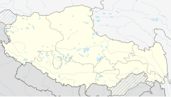
Risum Township[1] (Tibetan: རི་གསུམ་ཤང, Wylie: ri gsum shang) or Risong Township (simplified Chinese: 日松乡; traditional Chinese: 日松鄉; pinyin: Rìsōng Xiāng),[2] traditionally called Roksum in English,[2][3][a] is a township of Rutog County, in far western Tibet Autonomous Region, People's Republic of China.[5] It is directly serviced by China National Highway 219. The closest airport is the Ali Kunsha Airport.
Risum Township
རི་གསུམ་ཤང Roksum | |
|---|---|
| Risong Township | |
| Coordinates: 33°11.0′N 79°50.4′E / 33.1833°N 79.8400°E | |
| Country | People's Republic of China |
| Region | Tibet |
| Prefecture | Ngari |
| County | Rutog |
| Elevation | 4,335 m (14,222 ft) |
| Time zone | UTC+8 (China Standard) |
Villages
editVillages incorporated in the township are:[6]
- Deru Village (德汝村)[7] 33°22′15″N 79°41′43″E / 33.3707°N 79.6954°E
- Jiagang Village (甲岗村)[7] 32°52′27″N 79°50′30″E / 32.87412°N 79.8416°E
- Guoba Village (过巴村)[7]33°07′03″N 80°03′23″E / 33.1176°N 80.0565°E
- Risum Village[8] 33°11′50″N 79°49′14″E / 33.1971°N 79.8205°E lies at an altitude of 4,353 metres (14,281 ft). The village has a population of about 14 people. It is located 28 kilometres (17 mi) south of Pangong Tso, a large lake, and 81 km (50 mi) north of the seat of Ngari Prefecture. It lies approximately 22 km (13.9 mi) south of Rutog and 29 km (18.3 mi) north of Jaggang.
Notes
editReferences
edit- ^ Risum, geonames.org, retrieved 30 October 2022.
- ^ a b "Geographical names of Tibet AR (China): Ngari prefecture". KNAB Place Name Database. Institute of the Estonian Language. 2018-06-03.
- ^ Webster's Color Atlas of the World, Crescent Books, 1982, page 61.
- ^ Motgomerie, Report of the Trans-Himalayan Explorations during 1868 (1870), p. 48.
- ^ 2011年统计用区划代码和城乡划分代码:日土县 (in Chinese). National Bureau of Statistics of the People's Republic of China. Retrieved 2012-07-16.
- ^ Risong Township, National Bureau of Statistics, retrieved 30 October 2022.
- ^ a b c "Risong Township, Rutog, Tibet, China". www.cfguide.com. Retrieved 2020-11-30.
- ^ &Diacritics=DC Risum (Approved - N) at GEOnet Names Server, United States National Geospatial-Intelligence Agency
Bibliography
edit- Montgomerie, T. G. (1870), "Narrative Report of the Trans-Himalayan Explorations during 1868", Journal of the Asiatic Society of Bengal, 36 (part 2, issue 1): 47–
