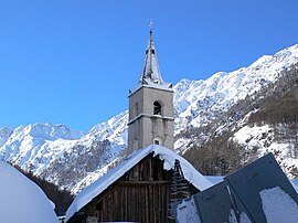
Ristolas is a former commune in the Hautes-Alpes department in southeastern France. On 1 January 2019, it was merged into the new commune of Abriès-Ristolas.[2] The village lies in the Queyras, in the northwestern part of the commune, on the left bank of the Guil, which has its source in the southeastern part of the commune.
Ristolas | |
|---|---|
Part of Abriès-Ristolas | |
 The church of Ristolas | |
| Coordinates: 44°46′29″N 6°57′23″E / 44.7747°N 6.9564°E | |
| Country | France |
| Region | Provence-Alpes-Côte d'Azur |
| Department | Hautes-Alpes |
| Arrondissement | Briançon |
| Canton | Guillestre |
| Commune | Abriès-Ristolas |
Area 1 | 82.18 km2 (31.73 sq mi) |
| Population (2021)[1] | 97 |
| • Density | 1.2/km2 (3.1/sq mi) |
| Time zone | UTC+01:00 (CET) |
| • Summer (DST) | UTC+02:00 (CEST) |
| Postal code | 05460 |
| Elevation | 1,571–3,294 m (5,154–10,807 ft) (avg. 1,610 m or 5,280 ft) |
| 1 French Land Register data, which excludes lakes, ponds, glaciers > 1 km2 (0.386 sq mi or 247 acres) and river estuaries. | |
Climate
edit| Climate data for Ristolas (1991–2020 averages, 2004–2024 extremes): elevation 1670m | |||||||||||||
|---|---|---|---|---|---|---|---|---|---|---|---|---|---|
| Month | Jan | Feb | Mar | Apr | May | Jun | Jul | Aug | Sep | Oct | Nov | Dec | Year |
| Record high °C (°F) | 15.1 (59.2) |
18.3 (64.9) |
19.6 (67.3) |
21.4 (70.5) |
26.3 (79.3) |
32.6 (90.7) |
31.3 (88.3) |
31.6 (88.9) |
29.9 (85.8) |
25.0 (77.0) |
19.8 (67.6) |
11.7 (53.1) |
32.6 (90.7) |
| Mean daily maximum °C (°F) | 2.8 (37.0) |
4.4 (39.9) |
7.1 (44.8) |
10.8 (51.4) |
14.9 (58.8) |
19.9 (67.8) |
23.1 (73.6) |
22.6 (72.7) |
18.7 (65.7) |
14.1 (57.4) |
7.3 (45.1) |
3.0 (37.4) |
12.4 (54.3) |
| Daily mean °C (°F) | −3.7 (25.3) |
−3.0 (26.6) |
0.5 (32.9) |
4.5 (40.1) |
8.1 (46.6) |
12.1 (53.8) |
14.4 (57.9) |
13.9 (57.0) |
10.6 (51.1) |
6.8 (44.2) |
1.3 (34.3) |
−3.1 (26.4) |
5.2 (41.4) |
| Mean daily minimum °C (°F) | −10.2 (13.6) |
−10.5 (13.1) |
−6.2 (20.8) |
−1.8 (28.8) |
1.2 (34.2) |
4.2 (39.6) |
5.6 (42.1) |
5.2 (41.4) |
2.6 (36.7) |
−0.5 (31.1) |
−4.6 (23.7) |
−9.2 (15.4) |
−2.0 (28.4) |
| Record low °C (°F) | −22.4 (−8.3) |
−26.0 (−14.8) |
−24.0 (−11.2) |
−15.5 (4.1) |
−9.0 (15.8) |
−5.3 (22.5) |
−1.7 (28.9) |
−4.2 (24.4) |
−8.3 (17.1) |
−15.5 (4.1) |
−21.7 (−7.1) |
−22.6 (−8.7) |
−26.0 (−14.8) |
| Average precipitation mm (inches) | 35.2 (1.39) |
35.5 (1.40) |
50.9 (2.00) |
102.5 (4.04) |
119.0 (4.69) |
93.5 (3.68) |
56.6 (2.23) |
50.9 (2.00) |
74.7 (2.94) |
83.9 (3.30) |
142.5 (5.61) |
47.7 (1.88) |
892.9 (35.16) |
| Source: Météo-France[3] | |||||||||||||
Population
edit
|
| ||||||||||||||||||||||||||||||||||||||||||||||||||||||||||||||||||||||||||||||||||||||||||||||||||||||||||||||||||
| Source: EHESS (1793–1999)[4] and INSEE[5] | |||||||||||||||||||||||||||||||||||||||||||||||||||||||||||||||||||||||||||||||||||||||||||||||||||||||||||||||||||
See also
editReferences
edit- ^ "Populations légales 2021" [Legal populations 2021] (PDF) (in French). INSEE. December 2023.
- ^ "Arrêté préfectoral portant création de la commune nouvelle d'Abriès-Ristolas" (PDF) (in French). Recueil des actes administratifs spécial n°05-2018-161. 17 October 2018. pp. 79–80.
- ^ "Fiche Climatologique Statistiques 1991-2020 et records" (PDF). Météo-France. Retrieved September 6, 2023.
- ^ Des villages de Cassini aux communes d'aujourd'hui: Commune data sheet Ristolas, EHESS (in French).
- ^ Populations légales 2016, INSEE
Wikimedia Commons has media related to Ristolas.


