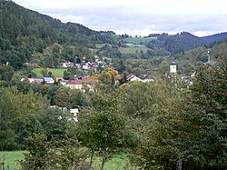
Rejštejn (German: Reichenstein) is a town in Klatovy District in the Plzeň Region of the Czech Republic. It has about 200 inhabitants. It belongs to the least populous towns in the country.
Rejštejn | |
|---|---|
 View of Rejštejn | |
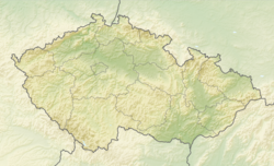
| Coordinates: 49°8′7″N 13°30′43″E / 49.13528°N 13.51194°E | |
| Country | |
| Region | Plzeň |
| District | Klatovy |
| First mentioned | 1337 |
| Government | |
| • Mayor | Horst Hasenöhrl Jr. |
| Area | |
| • Total | 30.44 km2 (11.75 sq mi) |
| Elevation | 568 m (1,864 ft) |
| Population (2024-01-01)[1] | |
| • Total | 242 |
| • Density | 8.0/km2 (21/sq mi) |
| Time zone | UTC+1 (CET) |
| • Summer (DST) | UTC+2 (CEST) |
| Postal code | 341 92 |
| Website | www |
Administrative parts
editThe villages of Jelenov, Klášterský Mlýn, Malý Kozí Hřbet, Radešov, Svojše, Velký Kozí Hřbet, Velký Radkov and Zhůří are administrative parts of Rejštejn.
Etymology
editThe original German name Reichenstein was created from am reichen Stein (meaning 'at the rich rock') and refers to the gold mining in the area. The Czech name was created by transliteration of the German one.[2]
Geography
editRejštejn is located about 32 kilometres (20 mi) southeast of Klatovy and 66 km (41 mi) south of Plzeň. It lies mostly in the Bohemian Forest mountain range and in the Šumava National Park, only the northern part of the municipal territory lies in the Bohemian Forest Foothills. The highest point is the mountain Huťská hora at 1,187 m (3,894 ft) above sea level. The Otava River is formed by the confluence of the Vydra and Křemelná rivers, located at the western municipal border, and then flows through the town proper.
History
editThe first written mention of Rejštejn is from 1337. Originally, it was administratively considered part of Kašperské Hory. Thanks to gold mining in the area, the settlement grew. In 1584, Rejštejn was promoted by Emperor Rudolf II to a royal mining town and gained independence. In the 17th century, mining ended and the development of the town stopped.[3]
A new impulse for the development of the town was the establishment of glass factories. In 1836, the glass factory of Jan Eisner was established in Klášterský Mlýn. The second notable factory in Klášterský Mlýn was the art glass manufacturer Joh. Loetz Witwe. As a result of the economic crisis and the world wars, glassmaking ended in 1947.[3]
Demographics
edit
|
|
| ||||||||||||||||||||||||||||||||||||||||||||||||||||||
| Source: Censuses[4][5] | ||||||||||||||||||||||||||||||||||||||||||||||||||||||||
Transport
editThere are no railways or major roads passing through the municipal territory.
Sights
editThe main landmark of Rejštejn is the Church of Saint Bartholomew. It is originally a late Gothic church from the turn of the 14th and 15th centuries, rebuilt in the Baroque style in the 18th century.[6]
A technical monument is the Čeňkova Pila hydroelectric power plant. It dates from 1912. Inside there is the original technical equipment and it is still in use today.[7]
References
edit- ^ "Population of Municipalities – 1 January 2024". Czech Statistical Office. 2024-05-17.
- ^ Profous, Antonín (1947). Místní jména v Čechách I: A–H (in Czech). p. 712.
- ^ a b "Historie Rejštejna" (in Czech). Město Rejštejn. Retrieved 2024-03-05.
- ^ "Historický lexikon obcí České republiky 1869–2011" (in Czech). Czech Statistical Office. 2015-12-21.
- ^ "Population Census 2021: Population by sex". Public Database. Czech Statistical Office. 2021-03-27.
- ^ "Kostel sv. Bartoloměje" (in Czech). National Heritage Institute. Retrieved 2023-12-08.
- ^ "Vodní elektrárna Čeňkova Pila" (in Czech). National Heritage Institute. Retrieved 2023-12-08.

