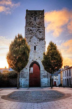
The Red Abbey in Cork, Ireland was a 14th-century Augustinian abbey which took its name from the reddish sandstone used in construction. Today all that remains of the structure is the central bell tower of the abbey church, which is one of the last remaining visible structures dating to the medieval walled town of Cork.[1]
 Red Abbey tower | |
| Monastery information | |
|---|---|
| Order | Augustinian |
| Architecture | |
| Heritage designation | Recorded monument #CO 074-041 |
History
editThe Red Abbey was built in Cork in either the late 13th or early 14th centuries,[3] though it was definitely in existence sometime before 1306.[4] It was founded by a member of the De Courcey family.[5] Despite being dissolved in 1541,[4] it was occupied by the friars until at least the rebellion of 1641, and possibly as late as 1700.[1]
The abbey tower was used by John Churchill (later the Duke of Marlborough) as a vantage point and battery during the Siege of Cork in 1690.[6] The siege sought to suppress an uprising in the city and its association with the expelled Catholic King of England, James II.
In the eighteenth century, the Augustinian friars established a new friary in Fishamble Lane, and the Red Abbey was turned over to use as a sugar refinery. However, a fire in the refinery destroyed much of the abbey's structure in 1799.[7]
The remains of the monastery were excavated in 1977. Fragmented human bones, pottery spanning from medieval up to the 19th century was uncovered, along with approximately 300 pieces of lead shot.[8] All that remains today of the structure is the bell tower of the abbey's church. The tower is designated as a national monument[9] and maintained by Cork City Council.[10]
Notable people
edit- William Tirry (1609–1654), a friar of the abbey's Augustinian order who was executed following the Cromwellian conquest of Ireland and beatified in 1992 as one of the Irish Catholic Martyrs.[11]
See also
editReferences
editNotes
edit- ^ a b "Red Abbey". CorkHeritage.ie. Retrieved 12 June 2017.
- ^ "Pacata Hibernia map, 1585-1600. Abbey is marked as "St. Austins"". Cork Past & Present. Cork City Library.
- ^ "Red Abbey Street". Cork Past & Present. Cork City Library. Retrieved 12 June 2017.
- ^ a b Sheehan, Hurley & Ní Loingsigh 2004, p. 1.
- ^ Lunham 1908, p. 33.
- ^ "Cork City 1645 to 1700". History of Cork. Cork City Council. Retrieved 12 June 2017.
- ^ "Red Abbey Cork City, Co. Cork". discoverireland.ie. Fáilte Ireland. Retrieved 9 August 2021.
- ^ O'Flaherty 1978, p. 91-92.
- ^ Peter Harbison (1970). Guide to the National Monuments of Ireland. Dublin.
{{cite book}}: CS1 maint: location missing publisher (link) - ^ "Buildings in the South Parish, Cork". southparishhistoricalsociety.ie. South Parish Historical Society. Retrieved 9 August 2021.
- ^ Cornish, Patrick J.; Millet, Benignus, eds. (2005). The Irish Martyrs. Dublin: Four Courts Press. pp. 176–183.
Sources
edit- Lunham, T. A. (1908). "The Red Abbey and its Tenants" (PDF). Journal of the Cork Historical and Archaeological Society. 14 (77): 33–35.
- O'Flaherty, Brendan D. (1978). "Red Abbey, Cork City" (PDF). Journal of the Cork Historical and Archaeological Society. 83 (238): 89–93.
- Sheehan, C.; Hurley, M. F.; Ní Loingsigh, M. (2004). "Excavations at the Red Abbey, Cork, 1992 and 2000" (PDF). Journal of the Cork Historical and Archaeological Society. 109: 1–38.
51°53′38″N 8°28′20″W / 51.89401°N 8.47234°W