This article includes a list of general references, but it lacks sufficient corresponding inline citations. (October 2020) |
Pont de Neuilly (French pronunciation: [pɔ̃ d(ə) nœji]) is a station on Paris Métro Line 1, situated in the prosperous suburban commune of Neuilly-sur-Seine. Between 1940 and 1950 it was known as Pont de Neuilly, Avenue de Madrid.
Pont de Neuilly | |||||||||||
|---|---|---|---|---|---|---|---|---|---|---|---|
 The platforms | |||||||||||
| General information | |||||||||||
| Location | 185, av. Charles de Gaulle 205, av. Charles de Gaulle 209, av. Charles de Gaulle Neuilly-sur-Seine Île-de-France France | ||||||||||
| Coordinates | 48°53′06″N 2°15′35″E / 48.88500°N 2.25972°E | ||||||||||
| Owned by | RATP | ||||||||||
| Operated by | RATP | ||||||||||
| Other information | |||||||||||
| Fare zone | 2 | ||||||||||
| History | |||||||||||
| Opened | 29 April 1937 | ||||||||||
| Services | |||||||||||
| |||||||||||
| |||||||||||
Location
editThe station is located under Avenue Charles-de-Gaulle (RN 13) at its intersection with Avenue de Madrid. Oriented approximately along a north-west/south-east axis, it is situated between the Esplanade de la Défense and Les Sablons metro stations, separated from the former by an above-ground crossing of the Seine river in the centre of the Pont de Neuilly bridge, with a grade of 6%, the steepest in the network. In the direction of La Défense, it is the last classic station available on this part of the line.
It is named after the Pont de Neuilly, a nearby bridge. The bridge - which carries parallel road and rail links between Neuilly and La Défense, over the river Seine - is in fact nearer to the Esplanade de la Défense metro station than to the Pont de Neuilly metro station.
It was the western terminus of Line 1 from 1937 until 1992, before the western extension to La Défense metro was opened. Above the station lies an esplanade from which one can see the area of La Défense.
History
editThe station was opened on 29 April 1937 as the western terminus of line 1 from Château de Vincennes, replacing the original terminus at Porte Maillot. It owes its name to its relative proximity to the Neuilly bridge, linking Neuilly-sur-Seine on the right bank of the Seine to the communes of Courbevoie and Puteaux on the left bank, in line with the historic Parisian axis. The station was named Pont de Neuilly - Avenue de Madrid from 1940 to 1950 to highlight its location at the intersection of the Avenue de Madrid, which takes its name from the capital of Spain.
The station was modernized after 1988 by the adoption of the decorative style Ouï-dire on the platforms, green in this case.
On 1 April 1992, it became a transit station with the inauguration of the extension to Grande Arche de la Défense (now La Défense). This extension required the complete takeover of the rear station in order to allow the passage of the line on the Pont de Neuillyy, the basement constrained at that time by the presence of the tunnel of RER A line, built during the 1960s.
As part of the automation of line 1, the platforms were raised to accommodate platform screen doors, installed between mid-June and mid-July 2009, making this station the second on the line to benefit from these doors after Bérault.[1]
In 2019, according to RATP estimates, 6,902,027 passengers entered this station, which places it in the 41st position of metro stations for its usage out of 302.[2] In the same year, the docks lost their asphalt pavement to dark tiles.
In 2020, with the Covid-19 crisis, 3,678,074 passengers entered this station, which places it in the 36th position of metro stations for its usage.[3]
In 2021, attendance gradually increases, with 4,822,599 passengers entering this station which places it in the 41st position of metro stations for its usage.[4]
Passenger services
editAccess
editThe station has three entrances divided into six metro accesses, established on the side medians of Avenue Charles-de-Gaulle:
- Access no. 1 Rue du Château: two fixed stairs, one decorated with a mast with a yellow "M" inscribed in a circle, leading to no. 168 of the avenue;
- Access no. 2 Avenue de Madrid: a fixed staircase to the right of no. 205 Avenue Charles-de-Gaulle and an escalator facing Nos. 203 and 203 bis;
- Access no. 3 Rue de l'Église: a fixed staircase with a yellow totem "M" leading to the right of no. 185 Avenue Charles-de-Gaulle and an escalator going up to the Église Saint-Jean-Baptiste de Neuilly-sur-Seine at no. 158.
Each stair hopper has the particularity, treated in flat brown tiles laid vertically and aligned.
Station layout
edit| Street Level |
| B1 | Mezzanine for platform connection |
| B2 Platforms |
Side platform with PSDs, doors will open on the right | |
| Westbound | ← toward La Défense – Grande Arche (Esplanade de La Défense) | |
| Eastbound | toward Château de Vincennes (Les Sablons)→ | |
| Side platform with PSDs, doors will open on the right | ||
Platforms
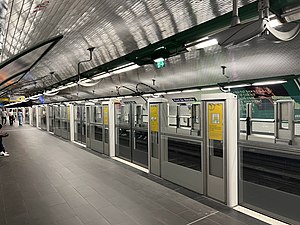
editPont de Neuilly is a standard configuration station. It has two platforms, 105 meters long, separated by the metro tracks and the vault is elliptical. The decoration is in the Ouï-dire green style. The lighting canopies, of the same colour, are supported by curved braces in the shape of a scythe. The direct lighting is white as well as, unlike most light canopies of this style, indirect lighting. The white ceramic tiles are flat and cover the walls, vault, tunnel exits and outlets of the corridors. The advertising frames are green and cylindrical and the name of the station is inscribed in Parisine font on enamelled plates. The platforms are tiled in anthracite grey and equipped with green Motte style shell seats as well platform screen doors.
Bus connections
editThe station is served by bus lines 43, 73, 93, 157, 158, 174 and 176 of the RATP Bus Network and by lines N11, N24 and N153 of the Noctilien night bus service.
Some of these lines terminate at the bus station overlooking the station; this space is extended to the northwest by an esplanade from which emerges a view of the business district of La Défense.
Nearby
edit- Église Saint-Jean-Baptiste de Neuilly-sur-Seine
Gallery
edit-
Eastbound view
-
Westbound view
-
MP 89 rolling stock arriving at Pont de Neuilly
References
edit- ^ "La ligne 1 du Métro s'automatise". MonCourbevoie.com. Archived from the original on 26 September 2022. Retrieved 30 June 2022.
- ^ "Trafic annuel entrant par station du réseau ferré 2019". data.ratp.fr (in French). Archived from the original on 26 May 2022. Retrieved 30 June 2022.
- ^ "Trafic annuel entrant par station du réseau ferré 2020". data.ratp.fr (in French). Archived from the original on 15 August 2022. Retrieved 30 June 2022.
- ^ "Trafic annuel entrant par station du réseau ferré 2021". data.ratp.fr (in French). Archived from the original on 10 November 2022. Retrieved 30 June 2022.
- Roland, Gérard (2003). Stations de métro. D’Abbesses à Wagram. Éditions Bonneton.
