You can help expand this article with text translated from the corresponding article in French. (December 2009) Click [show] for important translation instructions.
|
Pont-en-Royans (French pronunciation: [pɔ̃.t‿ɑ̃ ʁwajɑ̃]) is a commune in the Isère department in the Auvergne-Rhône-Alpes region in Southeastern France.[3] In 2021, it had a population of 802.
Pont-en-Royans | |
|---|---|
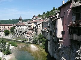
 A view of Pont-en-Royans | |
| Coordinates: 45°03′49″N 5°20′36″E / 45.0636°N 5.3433°E | |
| Country | France |
| Region | Auvergne-Rhône-Alpes |
| Department | Isère |
| Arrondissement | Grenoble |
| Canton | Le Sud Grésivaudan |
| Intercommunality | Saint-Marcellin Vercors Isère Communauté |
| Government | |
| • Mayor (2020–2026) | Bernard Grindatto[1] |
Area 1 | 2.9 km2 (1.1 sq mi) |
| Population (2022)[2] | 809 |
| • Density | 280/km2 (720/sq mi) |
| Time zone | UTC+01:00 (CET) |
| • Summer (DST) | UTC+02:00 (CEST) |
| INSEE/Postal code | 38319 /38680 |
| Elevation | 183–788 m (600–2,585 ft) (avg. 210 m or 690 ft) |
| Website | www.pontenroyans-vercors.fr |
| 1 French Land Register data, which excludes lakes, ponds, glaciers > 1 km2 (0.386 sq mi or 247 acres) and river estuaries. | |
Geography
editThe town is located near the Isère valley at the gates of the Vercors Regional Natural Park. It lies at the meeting of the rivers Bourne (which rises in Lans-en-Vercors) and its tributary the Vernaison (which originates in the territory of Saint-Agnan-en-Vercors). The two rivers together collect most of the waters of the Vercors. The left bank and the river after its confluence are located in the department of Drôme.
Population
edit| Year | Pop. | ±% p.a. |
|---|---|---|
| 1968 | 1,132 | — |
| 1975 | 1,094 | −0.49% |
| 1982 | 1,051 | −0.57% |
| 1990 | 879 | −2.21% |
| 1999 | 917 | +0.47% |
| 2009 | 853 | −0.72% |
| 2014 | 788 | −1.57% |
| 2020 | 795 | +0.15% |
| Source: INSEE[4] | ||
Twin towns
editPont-en-Royans has been twinned with Bassiano, Italy, since 1985.[citation needed]
Sights
editToday, Pont-en-Royans is a village displaying the medieval architecture of the sixteenth century and is famous for its colourful hanging houses. Its original architecture is due to an ingenious adaptation to the environment of the village to promote its trading activity with timber.
- The water museum aims to explore the water in all its forms. A bar allows water tasting of more than 900 bottled waters of the world.
- The Choranche caves lead through an underground river of stalactites. Unique amphibians (the proteas) are survivors from the time of dinosaurs.
- Circus choranche and cascading Gournier.
- Route des Gorges de la Bourne between Pont-en-Royans and Villard-de-Lans. Corbelled road carved into the rock and classified three stars in the Michelin guide. Work is being undertaken since 2008 to secure the route to the source of many accidents
See also
editReferences
edit- ^ "Répertoire national des élus: les maires". data.gouv.fr, Plateforme ouverte des données publiques françaises (in French). 2 December 2020.
- ^ "Populations de référence 2022" (in French). The National Institute of Statistics and Economic Studies. 19 December 2024.
- ^ INSEE commune file
- ^ Population en historique depuis 1968, INSEE


