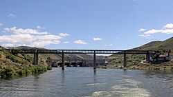
The Road-rail bridge of Pocinho, commonly known as Pocinho Bridge, is a road-rail bridge in Vila Nova de Foz Côa, Portugal. The structure was part of the now defunct rail network Sabor line, and is now closed to both types of transit.
Pocinho Bridge Ponte do Pocinho | |
|---|---|
 | |
| Coordinates | 41°08′04″N 7°07′12″W / 41.134512°N 7.120038°W |
| Carries | Sabor line |
| Crosses | Douro |
| Locale | Bragança District |
| Characteristics | |
| Total length | 262 m (860 ft) |
| History | |
| Opened | November 1903 |
| Inaugurated | 4 July 1909 |
| Closed | 1 August 1988 |
| Location | |
 | |
Construction
editIn the turn of the 19th century, the necessity of a new bridge above the Douro connecting the Estrada Real number 9 between the parishes of Pocinho and Miranda, in the Bragança District, arose. The two public tenders opened by the Portuguese Government in July 1901 and May 1902 were not successful,[1] so the Government authorized its railway department, Caminhos de Ferro do Estado, to negotiate the project with Empresa Industrial Portuguesa.[1][2] Construction started in 1903 and the bridge was opened to the public on 4 July 1909.[3] The upper board of the bridge was opened to exploration as part of the railway Sabor line on 1911.[4]
Decline and closure
editThe railway line was closed in 1988.[5] In 2001, car traffic was closed in the lower board of the bridge due to the existence of an alternative to the crossing using the Pocinho Dam, close to the centenary bridge.[6]
See also
editReferences
edit- ^ a b Ministério das Obras Públicas, Comércio e Indústria (16 March 1903). "Caminhos de ferro do Estado" (PDF). Gazeta dos Caminhos de Ferro (in Portuguese). pp. 83–84.
- ^ d’Abreu, Carlos; Abreu Vale, Jorge (24 November 2018). "Ponte Do Pocinho. Monumento Da Arqueologia Industrial Do Douro Transmontano Registado Pela Objectiva De Jorge Abreu Vale". Revista Memória Rural (in Portuguese). 1. C: 118.
- ^ Pinto, Francisco (7 January 2009). "Câmaras pedem classificação da ponte do Pocinho". Jornal de Notícias (in Portuguese).
- ^ "Troços de linhas férreas portuguesas abertas à exloração desde 1956, e sua extensão" (PDF). Gazeta dos Caminhos de Ferro (in Portuguese). 16 October 1956. p. 529.
- ^ Noé, Paula (2010). SIPA (ed.). "Ponte Ferroviária e Rodoviária do Pocinho (IPA.00024173)" (in Portuguese). Lisbon, Portugal: SIPA – Sistema de Informação para o Património Arquitectónico. Retrieved 5 May 2020.
- ^ "Ponte do Pocinho vai ser encerrada como precaução". Público (in Portuguese). 16 March 2001.
Sources
edit- Machado, Carlos Alberto d'Abreu Ferreira (2011). La vertebración del territorio ibérico de la raya duriense y las vías de transporte: éxitos y fracasos (PhD) (in Portuguese). University of Salamanca. doi:10.14201/gredos.115563.