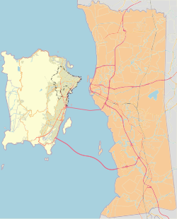
Permatang Damar Laut is a coastal village within the city of George Town in the Malaysian state of Penang.[1] It is located at the southern tip of Penang Island, about 17 km (11 mi) south of the city centre, making it the southernmost human settlement on the island. The village is hemmed in between the Penang International Airport to the north and the Malacca Strait to the south.
Permatang Damar Laut | |
|---|---|
Village in George Town | |
| Other transcription(s) | |
| • Mandarin | 峇东 (Simplified) 峇東 (Traditional) Bā dōng (Pinyin) |
| • Hokkien | Bā-tang (Tâi-lô) |
| • Tamil | பெர்மாடாங் டமர் லாட் |
 | |
 | |
| Coordinates: 5°16′40″N 100°16′02″E / 5.2778131°N 100.2673061°E | |
| Country | |
| State | |
| City | |
| Government | |
| • Local government | Penang Island City Council |
| • Mayor of Penang Island | Rajendran P. Anthony |
| • Batu Maung State Assemblyman | Mohamad Abdul Hamid (PKR) |
| • Bayan Baru Member of Parliament | Sim Tze Tzin (PKR) |
| Time zone | UTC+8 (MST) |
| • Summer (DST) | Not observed |
| Postal code | 11960 |
| Website | mbpp |
Etymology
editThe Malay word 'Permatang' refers to the village's geographic landform, as it is situated on a ridge surrounded by mangrove swamps.[2] 'Damar' in Malay means resin whilst 'Laut' is the Malay word for the sea; the village was purportedly where resin-producing trees once grew along the shore, hence the phrase 'Damar Laut'.
History
editAccording to historians in Universiti Sains Malaysia, the village of Permatang Damar Laut was founded in the late 18th century by three pioneers of Indonesian origin - Pah Kechil, Jamaluddin and Nakhoda Che Salleh.[3] The village was one of the handful of autonomous Malay settlements that were established at the south of Penang Island at the time.
Transportation
editThe main road within Permatang Damar Laut is Jalan Permatang Damar Laut, which forms part of the Federal Route 6. The thoroughfare cuts through the village, linking it with Batu Maung to the east and the old town of Bayan Lepas to the west. Permatang Damar Laut is also the southern terminus of Rapid Penang's bus route 302, which connects the village with several destinations along the eastern half of Penang Island, such as Batu Maung, Bayan Lepas, Bayan Baru, SPICE Arena and the city centre.[4]
To alleviate worsening traffic congestion in the area, the Malaysian Public Works Department has widened a stretch of the road leading to the village in 2017.[5] The project also included the construction of a flyover and an elevated U-turn.
Education
editPermatang Damar Laut is served by a single primary school - SRK Permatang Damar Laut.[6]
Health care
editThe village contains a haemodialysis centre operated by the Penang Fo Yi Haemodialysis Society.[7] Opened in 2017, the Fo Yi Medicare Centre is equipped with 30 dialysis machines, which allow it to treat 180 kidney patients per month.
See also
editReferences
edit- ^ "George Town meliputi 'pulau', jelas Datuk Bandar" (PDF). Buletin Mutiara. 1 May 2015.
- ^ Raudhah. "Permatang Damar Laut". cis.penanglib.gov.my (in Malay). Retrieved 2018-02-09.
- ^ Haji Salleh, Muhammad (2015). Early History of Penang. Penang: Universiti Sains Malaysia. ISBN 9789838616577.
- ^ Route map rapidpg.com.my Archived 2016-07-02 at the Wayback Machine
- ^ "Widening of Bayan Lepas-Teluk Kumbar stretch ready in December - Metro News | The Star Online". www.thestar.com.my. Retrieved 2018-02-09.
- ^ "SK PERMATANG DAMAR LAUT - PULAU PINANG - Carian Sekolah Malaysia". www.sekolahmy.com (in Malay). Retrieved 2018-02-08.
- ^ "RM8mil Fo Yi Medicare Centre ready to serve people - Metro News - The Star Online". www.thestar.com.my.
