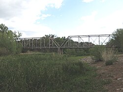
The Perkinsville Bridge over the Verde River was established in 1936 when it was moved from the San Carlos Indian Reservation over the Gila River.[2] The current structure was constructed from spans of the San Carlos Bridge which was built in 1913 and then rebuilt in 1921 after damage due to flooding.[2] It was listed on the National Register of Historic Places in 1989.[1]
Perkinsville Bridge | |
|---|---|
 View showing diagonal element far from center, not crossed, and crossing elements near center | |
| Coordinates | 34°53′42″N 112°12′18″W / 34.895°N 112.205°W |
| Carries | Perkinsville-Williams Road (Forest Route 318) |
| Crosses | Verde River |
| Locale | near Ash Fork, Arizona |
| Official name | Perkinsville Bridge |
| Other name(s) | Perkinsville Verde River Bridge |
| Characteristics | |
| Design | Pratt through truss |
| Material | Steel |
| Total length | 330 feet (100 m) |
| Width | 14 feet (4.3 m) |
| Longest span | 139 feet (42 m) |
| No. of spans | 2 |
| History | |
| Construction start | 1913, 1921 |
| Construction end | 1936 |
| Statistics | |
| Daily traffic | road |
Perkinsville Bridge | |
 | |
| Nearest city | Ash Fork, Arizona |
| Coordinates | 34°53′43″N 112°12′18″W / 34.89528°N 112.20500°W |
| Built | 1913; 1921 |
| Architect | US Indian Service; Et al. |
| Architectural style | Pratt through truss |
| MPS | Vehicular Bridges in Arizona MPS |
| NRHP reference No. | 88001671[1] |
| Added to NRHP | March 31, 1989 |
| Location | |
 | |
See also
edit- Verde River Bridge, also NRHP-listed
- Verde River Sheep Bridge, also NRHP-listed
References
editExternal links
editWikimedia Commons has media related to Perkinsville Bridge.

