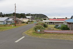
Pacific Beach is a census-designated place (CDP) in Grays Harbor County, Washington, United States. The population was 280 at the 2020 census,[3] down from 291 at the 2010 census.[2] Prior to 2010 it was part of the Moclips CDP.
Pacific Beach, Washington | |
|---|---|
 View of the community | |
| Coordinates: 47°12′32″N 124°12′11″W / 47.20889°N 124.20306°W | |
| Country | United States |
| State | Washington |
| County | Grays Harbor |
| Area | |
• Total | 1.23 sq mi (3.19 km2) |
| • Land | 1.21 sq mi (3.13 km2) |
| • Water | 0.03 sq mi (0.07 km2) |
| Elevation | 50 ft (20 m) |
| Population (2020) | |
• Total | 280 |
| • Density | 230/sq mi (88/km2) |
| Time zone | UTC-8 (Pacific (PST)) |
| • Summer (DST) | UTC-7 (PDT) |
| ZIP code | 98571[1] |
| Area code | 360 |
| FIPS code | 53-52530[2] |
| GNIS feature ID | 1512546 |
Geography
editPacific Beach is located in western Grays Harbor County, along the Pacific Ocean. It is bordered to the north by Moclips and to the south by Joe Creek. The CDP includes the neighborhood of Highland Heights, north of Pacific Beach proper. State Route 109 passes through the CDP, leading north through Moclips 11 miles (18 km) to its terminus at Taholah, and south 8 miles (13 km) to Copalis Beach. Hoquiam is 25 miles (40 km) to the southeast.
According to the United States Census Bureau, the Pacific Beach CDP has a total area of 1.2 square miles (3.2 km2), of which 0.03 square miles (0.07 km2), or 2.07%, are water.[2]
References
edit- ^ "Pacific Beach WA ZIP Code". zipdatamaps.com. 2023. Retrieved June 16, 2023.
- ^ a b c "Geographic Identifiers: 2010 Demographic Profile Data (G001): Pacific Beach CDP, Washington". American Factfinder. U.S. Census Bureau. Retrieved March 31, 2017.
- ^ "Census Bureau profile: Pacific Beach, Washington". United States Census Bureau. May 2023. Retrieved May 10, 2024.

