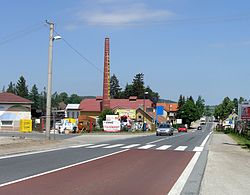
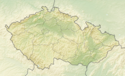
Olbramovice is a municipality and village in Benešov District in the Central Bohemian Region of the Czech Republic. It has about 1,400 inhabitants.
Olbramovice | |
|---|---|
 Main road | |
| Coordinates: 49°40′2″N 14°38′22″E / 49.66722°N 14.63944°E | |
| Country | |
| Region | Central Bohemian |
| District | Benešov |
| First mentioned | 1352 |
| Area | |
• Total | 25.37 km2 (9.80 sq mi) |
| Elevation | 418 m (1,371 ft) |
| Population (2024-01-01)[1] | |
• Total | 1,418 |
| • Density | 56/km2 (140/sq mi) |
| Time zone | UTC+1 (CET) |
| • Summer (DST) | UTC+2 (CEST) |
| Postal codes | 257 53, 259 01 |
| Website | www |
Administrative division
editOlbramovice consists of 15 municipal parts (in brackets population according to the 2021 census):[2]
- Olbramovice Městečko (60)
- Olbramovice Ves (756)
- Babice (0)
- Dvůr Semtín (2)
- Kochnov (9)
- Křešice (107)
- Mokřany (6)
- Podolí (5)
- Radotín (11)
- Semtín (27)
- Semtínek (13)
- Slavkov (41)
- Tomice II (162)
- Veselka (120)
- Zahradnice (47)
Geography
editOlbramovice is located about 13 kilometres (8 mi) south of Benešov. It lies on the border of the Benešov Uplands and Vlašim Uplands. The highest point is at 620 m (2,030 ft) above sea level. The municipal territory is rich in minor streams and fishponds.
The largest and most significant pond is Podhrázský rybník. Together with its surroundings it is protected as a nature reserve. It is an important ornithological site.[3]
History
editThe first written mention of Olbramovice is from 1352.[3]
Demographics
edit
|
|
| ||||||||||||||||||||||||||||||||||||||||||||||||||||||
| Source: Censuses[4][5] | ||||||||||||||||||||||||||||||||||||||||||||||||||||||||
Transport
editThe I/3 road (part of the European route E55), which replaces the unfinished section of the D3 motorway from Prague to Tábor, passes through the municipality.
Olbramovice is located on the important railway line Prague–Tábor, which further continues to České Budějovice or to České Velenice and Vienna.[6]
Sights
editThe main landmark of Olbramovice is the Church of All Saints. It has Romanesque origins from the 12th century. In 1866, it was rebuilt in the neo-Romanesque style.[7]
Notable people
edit- Harry Pollak (1923–2014), mechanical engineer and economist
References
edit- ^ "Population of Municipalities – 1 January 2024". Czech Statistical Office. 2024-05-17.
- ^ "Public Census 2021 – basic data". Public Database (in Czech). Czech Statistical Office. 2022.
- ^ a b "Historie a zajímavosti" (in Czech). Obec Olbramovice. Retrieved 2023-04-11.
- ^ "Historický lexikon obcí České republiky 1869–2011" (in Czech). Czech Statistical Office. 2015-12-21.
- ^ "Population Census 2021: Population by sex". Public Database. Czech Statistical Office. 2021-03-27.
- ^ "Detail stanice Olbramovice" (in Czech). České dráhy. Retrieved 2024-02-21.
- ^ "Kostel Všech svatých" (in Czech). National Heritage Institute. Retrieved 2023-04-11.


