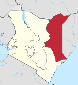
The North Eastern Province is one of the former provinces of Kenya. It had a land area of 127,358.5 km2, with its capital at Garissa. The North Eastern Province was carved out of the then Northern Frontier District (NFD) prior to independence.[1]
North Eastern Province | |
|---|---|
 Location in Kenya | |
| Coordinates: 1°0′N 40°15′E / 1.000°N 40.250°E | |
| Country | |
| Capital | Garissa |
| Area | |
• Total | 127,358.5 km2 (49,173.4 sq mi) |
| Population (2009) | |
• Total | 2,310,757 |
| • Density | 18/km2 (47/sq mi) |
| Time zone | UTC+3 (EAT) |
During negotiations for Kenya's independence, Britain granted administration of the NFD which included all of the North Eastern province to Kenyan nationalists despite an informal plebiscite showing the overwhelming desire of the region's population to join the newly formed Somali Republic. It is, and has historically been, mostly inhabited by Somalis.[2][3]
Demographics
editAs of 2009, the North Eastern Province had a population of 2,310,757 residents.[4] These census results were however nullified by the then Planning Minister Wycliffe Oparanya citing inconsistencies in the birth and death rates.[5] On 21 March 2016, the court of appeal in Nairobi, declared the disputed census results valid.[6] The North Eastern Province is predominantly inhabited by ethnic Somalis.[7]
The Somalis in the North Eastern Province of Kenya numbered close to three million in the 2019 National Census with another 280,000 settled in refugee camps from neighbouring Somalia.[8]
Administration
editNorth Eastern Province had thirteen constituencies represented in the National Assembly of Kenya, under the Government of Kenya. The Regional Commissioner sat in Garissa. The last Regional Commissioner was Mohamed Birik.
As the capital of Garissa County, Garissa is the seat of the County Government of Garissa as well as the County Assembly. The town is represented by Aden Bare Duale, a Somali Member of Parliament for the Garissa Township Constituency and who also doubles as the Leader of the Majority in the legislature. He was appointed to the position in the 2013 general elections. The county is also home to Ijara, Dadaab, Lagdera, Fafi and Balambala constituencies.[9]
Wajir is the largest county in the former North Eastern Province with approximately an area of 56,000km2. The county has six constituencies. They include Eldas, Tarbaj, Wajir East, Wajir North, Wajir West, and Wajir South.[10]
Mandera County is at the furthermost bordering both the Somalia and Ethiopia's Somali Region. It has six constituencies just like the rest of the counties in the North Eastern province. These constituencies include Banissa, Lafey, Mandera East, Mandera North, Mandera South, Mandera West and Takaba.[11]
Economy
editLivestock and agricultural production is a significant part of the region's economy. Between 2005 and 2007, Garissa cattle producers earned over 1.8 billion shillings in sales in domestic and overseas markets. Construction of a new abattoir also began in October 2007.[12] In terms of livestock imports, most of Garissa's cattle comes from cross-border trade between Somali livestock merchants.[13]
Transportation
editNorth Eastern Province is served by the Wajir Airport. It handles about seven flights per day. As of September 2012, civil flights are offered twice a week by Echo. Most flights, however, are cargo. Some charter and military flights are additionally accommodated.[14]
Climate and habitat
editNorth Eastern Province has a semi-arid and hot desert climate (Köppen BSh and BWh). Rain falls infrequently, usually only around April or October, and quite sporadically from year to year. Although the southwestern section of the Somali autonomous region is extremely fertile where the Tana River is located with a lot of farming.
There is a major river called Tana River which is located in the southwestern section of the region. Wildlife in the area include the lion, elephant, buffalo, zebra, hyena, gazelle, giraffe, leopard, cheetah, and ostrich. Hippopotamus and crocodiles are mainly located on the river.
Counties
edit| Code | County | Former province | Area (km2) | Population Census 2009 |
Capital |
|---|---|---|---|---|---|
| 7 | Garissa | North Eastern | 45,720.2 | 623,060 | Garissa |
| 8 | Wajir | North Eastern | 55,840.6 | 661,941 | Wajir |
| 9 | Mandera | North Eastern | 25,797.7 | 1,025,756 | Mandera |
| Totals | 127,358.5 | 2,310,757 | - |
After 2007
editSee also
editReferences
edit- ^ Osman, Mohamed Amin AH (1993). Somalia, proposals for the future. SPM. pp. 1–10.
- ^ Rhoda E. Howard, Human Rights in Commonwealth Africa, (Rowman & Littlefield Publishers, Inc.: 1986), p.95
- ^ William T. Pink, George W. Noblit (3 September 2008). International Handbook of Urban Education. Springer Science & Business Media. p. 130. ISBN 9781402051999.
- ^ "Kenya Census 2009". Kenya National Bureau of Statistics. Retrieved 7 January 2015.
- ^ "Some Kenya Census results nullified » Capital News". Capital News. 31 August 2010. Retrieved 30 May 2020.
- ^ Muthoni, Kamau. "Court declares disputed 2009 census results valid". The Standard. Retrieved 30 May 2020.
- ^ Lewis, I. M. (1963). "The Problem of the Northern Frontier District of Kenya". Race. 5 (1): 48–60.
- ^ "Somali refugees in Kenya: increasing camp-urban mobility - Kenya | ReliefWeb". reliefweb.int. 23 November 2023.
- ^ "County Overview – Garissa County Government". Retrieved 30 May 2020.
- ^ Government, Wajir County. "Wajir County Government || The Transformaton is ON". wajir.go.ke. Archived from the original on 14 July 2013. Retrieved 30 May 2020.
{{cite web}}: Check|url=value (help) - ^ Manderacounty-Admin. "Demographics". County Government of Mandera. Retrieved 30 May 2020.
- ^ Government targets Kshs 12 b for development in N. Eastern Archived 28 September 2013 at the Wayback Machine
- ^ Livestock Supply in Kenya[usurped]
- ^ History of Wajir Airport
- ^ Ministry of State for Provincial Administration and National Security Archived 5 March 2009 at the Wayback Machine