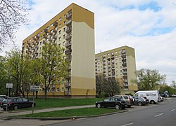
Niedźwiadek[a] is a residential neighbourhood built between 1968 and 1978 under the official name Spółdzielcze Osiedle Mieszkaniowe "Niedźwiadek";[2] since 2003, it also is the name of an area in City Information System. Both are part of Ursus district, Warsaw, Poland.[3]
Niedźwiadek | |
|---|---|
Neighbourhood and City Information System area | |
 The apartment buildings in Niedźwiadek, in 2017. | |
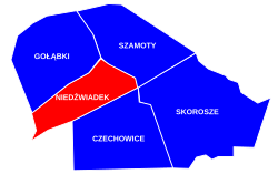
 Location of Niedźwiadek within the district of Ursus, in accordance to the City Information System. | |
| Coordinates: 52°11′48″N 20°52′15″E / 52.19667°N 20.87083°E | |
| Country | Poland |
| Voivodeship | Masovian |
| City county | Warsaw |
| District | Ursus |
| Time zone | UTC+1 (CET) |
| • Summer (DST) | UTC+2 (CEST) |
| Area code | +48 22 |
The neighbourhood was built between 1968 and 1977, to provide housing to the employees of the nearby Ursus factory.[4][5]
History
editBefore the 1960s
editThe land on which today's Niedźwiadek stands, for several decades was divided into several farms, which belonged ie. to Krystian and Petronela Hass (the other family branch had a farm in Skorosze, to the southeast), Antoni Boguszewski, and Leon Haas[b]. In 1935, Hass' land was divided between family' children – western part was given to Krystian's son Zygmunt, while eastern was given to the couple's seven daughters. Zygmunt's son, Antoni, inherited the land after World War II.[6]
1965–1978: construction of Niedźwiadek
editWork on the new neighborhood for Ursus factory workers began in the early 1960s. 1964 saw the first preparation works carried out;[7] on 9 January 1965, the Association of Polish Architects announced the results of a competition for the neighborhood's design. The winning project was designed by Stefan Putowski, which ensured favorable spatial conditions and a relatively large diversity of urban interior, on which AoPA put the major emphasis.[8]
In the project, Putowski designed the neighborhood's north-south axis along Wołodyjowskiego Street (today's Keniga Street[9]), which in the southern part was to pass under the former Warsaw-Vienna railway (today's lines No. 1 and No. 447), to the southern part of Ursus, where it was to connect with planned Ursus-West neighborhood and eventually with Kompanii Kordian Street.[8] Both neighborhoods were to be served by a railway stop on railway line no. 447. In Niedźwiadek itself, the plan was to build several schools, kindergartens, a hotel and a community centre.[10]
The construction of Niedźwiadek began in 1968.[11] First buildings were constructed on Sienkiewicza Street (today's Wojciechowskiego Street[12]), on lands previously owned by Antoni Hass and Leon Haas. In 1973, the neighborhood was granted its primary school, as Primary School No. 1 moved in from Czechowice.[13] First regular public transport connection from Warsaw, in the form of a busline, reached Niedźwiadek in January 1977.[14]
The construction work was finished in 1978.[15] Niedźwiadek had 18,500 inhabitants living in 83 buildings, and the neighborhood covered an area of 60 ha in total, managed by Robotnicza Spółdzielnia Mieszkaniowa Ursus (Ursus Worker's Housing Association).[11] The finished neighborhood was bigger than in Putowski's project, as the final area included the part intended to separate Niedźwiadek from planned (and eventually not built) municipal cemetery, but there were 1,100 inhabitants less than Putowski had planned.[16][11]
Since 1978
editThe original project, per communist government policy, did not have any church; yet, the 1980s saw the construction of the first Roman Catholic parish church, Our Lady of Fatima Sanctuary, in Niedźwiadek's western part.[17] Former farm of Antoni Boguszewski was demolished around the same time, and on its place, a hotel for Ursus factory workers was constructed.[18] In the 1990s, the lands of Antoni Hass were divided into several parts: in the southern part, a bazaar and a swimming pool were built; the northern part was given for the construction of a small Gawra neighborhood; in the central part, a second parish church for Niedźwiadek was built at the turn of the century,[17] and in 2007, the remaining part of Hass' family land was turned into public park.[19]
The railway stop that was planned in 1960s was eventually built and put into operation in 2014, almost 50 years after the first mentions by Association of Polish Architects. The Ursus-West neighborhood was never built.[11]
Since 2003\ Niedźwiadek neighborhood shares the name with the City Information System area, which is larger than the original neighborhood.[20][21]
Characteristics
editNiedźwiadek is a residential area, with multifamily residential apartment buildings.[4]
Niedźwiadek is served by railway stop named after the neighborhood, located on the railway line no. 447,[22] which runs along the railway line no. 1.[3]
Through the western portion of Niedźwiadek goes a section of the Expressway S2.[4][23]
Locations and administrative boundaries
editNiedźwiadek is located within the central-western portion of the district of Ursus, in the city of Warsaw, Poland. In accordance to the City Information System, its boundaries are determent by Warszawska Street to the north, Gierdziejewskiego Street, and Cierlicka Street to the east, the railway line no. 447 to the south, and the railway line no. 1 to the west.[3]
The neighbourhood borders Gołąbki to the north, Szamoty to the north-east, Skorosze to the south-east, Czechowice to the south, and Piastów to the south-west. The western border of the neighborhood marks the border of both the district of Ursus, and the city of Warsaw, and is adjusted to the town of Piastów in Pruszków County.[3]
Citations
editNotes
edit- ^ Polish pronunciation: [ɲɛd͡ʑˈvjadɛk]. Literal translation from Polish is "bear cub", while "Architektura" gave "A Bear-Cub" as English translation.[1]
- ^ Despite the similarity, Haas and Hass families were unrelated.
References
edit- ^ "Contents". Architektura. 1965 nr 6 = 211 (czerwiec). Wydawnictwo "Arkady".
- ^ "In memoriam – Pamięci Architektów Polskich – Stefan Bernard Putowski". www.archimemory.pl. Retrieved 18 February 2024.
- ^ a b c d "Obszary MSI. Dzielnica Ursus". zdm.waw.pl (in Polish).
- ^ a b c Ula Olczak (5 September 2022). "Niedźwiadek – mieszkania. Dlaczego warto zamieszkać w tej lokalizacji?". obido.pl (in Polish).
- ^ "Historia Ursusa". ursus.warszawa.pl (in Polish).
- ^ Domżalski, Jerzy (2002). Wiek XX w Ursusie (in Polish). Wydawnictwo "Ezdorat". pp. 49–51.
- ^ Domżalski, Jerzy (2014). W Ursusie i jego okolicy (in Polish). Wydawnictwo Liwona. p. 124.
- ^ a b "Architektura. 1965 nr 6 = 211 (czerwiec)" (in Polish). Wydawnictwo "Arkady". pp. 246–247.
- ^ Domżalski, Jerzy (2018). Patroni ulic Dzielnicy Ursus m.st. Warszawy (in Polish). Urząd Dzielnicy Ursus m.st. Warszawy. p. 17.
- ^ Domżalski, Jerzy (2014). W Ursusie i jego okolicy (in Polish). Wydawnictwo Liwona. pp. 124–125.
- ^ a b c d Domżalski, Jerzy (2014). W Ursusie i jego okolicy (in Polish). Wydawnictwo Liwona. p. 125.
- ^ Domżalski, Jerzy (2018). Patroni ulic Dzielnicy Ursus m.st. Warszawy (in Polish). Urząd Dzielnicy Ursus m.st. Warszawy. pp. 32–33.
- ^ "Nasz profil – Historia szkoły | Szkoła Podstawowa nr 11 im. Żołnierzy I Dywizji Kościuszkowskiej w Warszawie" (in Polish). Retrieved 13 February 2024.
- ^ Domżalski, Jerzy (2002). Wiek XX w Ursusie (in Polish). Wydawnictwo "Ezdorat". p. 140.
- ^ Domżalski, Jerzy (2002). Wiek XX w Ursusie (in Polish). Wydawnictwo "Ezdorat". p. 51.
- ^ "Architektura. 1967 nr 8 = 237 (sierpień)" (in Polish). Wydawnictwo "Arkady". p. 320.
- ^ a b Domżalski, Jerzy (2002). Wiek XX w Ursusie (in Polish). Wydawnictwo "Ezdorat". p. 142.
- ^ Domżalski, Jerzy (2002). Wiek XX w Ursusie (in Polish). Wydawnictwo "Ezdorat". p. 50.
- ^ "Parki w Ursusie". ursus.um.warszawa.pl (in Polish).
- ^ "Obszary MSI. Dzielnica Ursus". Zarząd Dróg Miejskich (in Polish). zdm.waw.pl. Retrieved 20 April 2022.
- ^ "Uchwała nr 44/XIV/2003 Rady Dzielnicy Ursus m.st. Warszawy z dnia 2 października 2003 r. w sprawie: Zatwierdzenia podziału dzielnicy Ursus na 5 obszarów w celu wdrożenia Miejskiego Systemu Informacji (MSI) na tym terenie" (PDF) (in Polish).
- ^ "Pasażerowie mogą już korzystać z nowego przystanku Warszawa Ursus-Niedźwiadek". ztm.waw.pl (in Polish). 27 December 2013.
- ^ Mapa lokalizacji węzłów drogowych wraz z ich numeracją zgodną z zasadami oznakowania eksperymentalnego. Warsaw: General Directorate for National Roads and Highways. 27 June 2022. (in Polish)