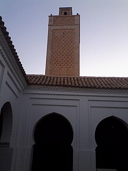
Nedroma (Arabic: ندرومة) is a city in Tlemcen Province, in northwestern Algeria, about 77 kilometres (48 mi) from Tlemcen. Once the capital of Trara, it was built on the ruins of a Berber town by Abd al-Mu'min the Almohad caliph. It has a great Islamic history, with its Great Mosque of Nedroma once containing the earliest surviving Almoravid minbar. Nedroma became a UNESCO World Heritage in 2002 for its cultural importance.
Nedroma
ندرومة | |
|---|---|
City | |
 Minaret of the Great Mosque of Nedroma | |
| Coordinates: 35°0′42″N 01°44′56″W / 35.01167°N 1.74889°W | |
| Country | Algeria |
| Province | Tlemcen |
| District | Nedroma |
| Area | |
• Total | 14 km2 (5 sq mi) |
| Population (2008 census) | |
• Total | 32,398 |
| • Density | 2,300/km2 (6,000/sq mi) |
| Time zone | UTC+1 (CET) |
| Postal code | 13600 |
History
editMany families of Andalusian and Moorish origin sought refuge in this city during the Reconquista.[1]
At the beginning of the 16th century, Nedroma became an important textile[2] center, specializing in cotton wovens and blankets. Nedroma, although far from Algiers, was an administrative center of the Trara,[3] extending its influence to neighboring towns. The Andalusian influence is also due to the second wave of Morisco refugees from Spain, following the decree of Expulsion of the Moriscos[4] in 1609.[5] Spanish-Arab philologist Guillermo Rittwagen described the city as having maintained its Andalusian heritage.[6]
At the beginning of the 19th century, it had 2,500 to 3,000 inhabitants,[7] it was among the small towns of precolonial Algeria[8] like Kalaa and Mazouna. Its population is made up notably of exiles from Spain and a minority of Jews[9]
Once the capital of Trara, it was built on the ruins of a Berber town by Abd al-Mu'min the Almohad caliph, who himself was a native of the neighboring mountains.[10] the town has a great history of Islam.[11] The earliest surviving Almoravid minbar, dated to around A.H. 479, once belonged to the Great Mosque of Nedroma. It is now on display in the Musée Nationale des Antiquités Classiques et Musulmanes in Algiers.[12] In the 1930s Ulama organizations, particularly the Boy Scouts sprang up in Nedroma and other ancient cities of the interior such as Tlemcen and Constantine.[13]
Riots broke out in the town on 15 October 1953, killing one person and injuring several. 26 were convicted.[14]
Nedroma was added to the UNESCO World Heritage Tentative List on December 30, 2002 in the Cultural category.[10]
Geography
editNedroma is situated to the north of the Trara Hills, 77 kilometres (48 mi) from Tlemcen, and about 340 kilometres (210 mi) west of Algiers.[15] The N99 highway passes south-north through the town, connecting it to Maghnia in the south and Ghazaouet on the coast. The W100 road leads to El Houanet in the southwest, and the W38 road leads to Aïn Kebira and Bentalha in the northeast.[16]
Landmarks
editNedroma contains the Great Mosque of Nedroma (Sidi Yahia Mosque) and the Nedroma Hospital in the northern outskirts along the N99.[16] Baked brick is a common building material in the town.[17]
References
edit- ^ "Reconquista: How the Christian Kingdoms Took Spain from the Moors". TheCollector. 2022-01-15. Retrieved 2023-09-13.
- ^ Côte, Marc (1996). Guide d'Algérie: paysages et patrimoine. Algérie: media-plus. ISBN 978-9961-922-00-2.
- ^ mondial, UNESCO Centre du patrimoine. "Nedroma et les Trara". UNESCO Centre du patrimoine mondial (in French). Retrieved 2023-09-12.
- ^ "Expulsion of the Muslims from Spain". EGO(http://www.ieg-ego.eu) (in German). Retrieved 2023-09-12.
- ^ "The Expulsion of the Moriscos, 1609–1614 | History Today". www.historytoday.com. Retrieved 2023-09-12.
- ^ "Culture et traditions de Nedroma". nedroma.free.fr. Retrieved 2023-09-13.
- ^ Benkada, Saddek (2019). Oran 1732–1912: essai d'analyse de la transition historique d' une ville algérienne vers la modernité urbaine. Réghaia, Alger: Éditions CRASC. ISBN 978-9931-598-22-0.
- ^ Gallissot, René (November 1975). "Precolonial Algeria∗". Economy and Society. 4 (4): 418–445. doi:10.1080/03085147500000012. ISSN 0308-5147.
- ^ Trevisan, Emanuela (2012-11-01). "Memory and Forgetting among Jews from the Arab-Muslim Countries. Contested Narratives of a Shared Past". Quest. Issues in Contemporary Jewish History. Retrieved 2023-09-12.
- ^ a b "Nedroma et les Trara" (in French). UNESCO World Heritage Centre. Retrieved 15 October 2016.
- ^ Ageron, Charles Robert (1991). Modern Algeria: A History from 1830 to the Present. C. Hurst & Co. Publishers. p. 77. ISBN 978-1-85065-027-0.
- ^ Dodds, Jerrilynn Denise (January 1992). Al-Andalus: The Art of Islamic Spain. Metropolitan Museum of Art. p. 364. ISBN 978-0-87099-636-8.
- ^ Stora, Benjamin; Todd, Jane Marie (2004). Algeria, 1830–2000: A Short History. Cornell University Press. p. 17. ISBN 0-8014-8916-4.
- ^ Holland, R. F (6 December 2012). Emergencies and Disorder in the European Empires After 1945. Routledge. p. 24. ISBN 978-1-136-29725-0.
- ^ Oakes, Jonathan (2008). Algeria. Bradt Travel Guides. p. 149. ISBN 978-1-84162-232-3.
- ^ a b "Nedroma" (Map). Google Maps. Retrieved 15 October 2016.
- ^ Petersen, Andrew (11 March 2002). Dictionary of Islamic Architecture. Routledge. p. 13. ISBN 978-1-134-61365-6.
