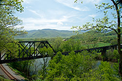
Natural Bridge Station is an unincorporated community in Rockbridge County, Virginia, United States, named for both its proximity to Natural Bridge and formerly having a train depot along the Norfolk & Western rail line. Formerly known as Sherwood and Greenlee, the community is located along the James River and Virginia State Route 130, 3.2 miles (5.1 km) west of Glasgow.
Natural Bridge Station, Virginia (Greenlee) | |
|---|---|
Unincorporated community | |
 The James River is framed by crossing railway lines at Natural Bridge Station. | |
| Coordinates: 37°37′15″N 79°30′21″W / 37.62083°N 79.50583°W | |
| Country | United States |
| State | Virginia |
| County | Rockbridge |
| Rockbridge Board of Supervisors Current Term | January 1, 2020 - December 31, 2023 |
| Government | |
| • Type | County District (Natural Bridge, Rockbridge County) |
| • District Supervisor | David B. McDaniel |
| Area | |
| • Total | 33.1 sq mi (86 km2) |
| • Land | 32.7 sq mi (85 km2) |
| • Water | 0.4 sq mi (1 km2) |
| Elevation | 764 ft (233 m) |
| Population (2020) | |
| • Total | 1,540 |
| • Density | 47/sq mi (18/km2) |
| Time zone | UTC-5 (Eastern (EST)) |
| • Summer (DST) | UTC-4 (EDT) |
| ZIP code | 24579 |
| Area code | 540 |
| GNIS feature ID | 1493338[1] |
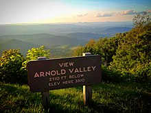
Natural Bridge Station is made up mostly of the southeastern corner of Rockbridge County encompassing all of the community of Arnolds Valley (named for the area's first settler, Stephen Arnold) and partially covering several other communities, with its southeastern border running along the Blue Ridge Parkway. Natural Bridge Station has a post office with ZIP code 24579.[2] The population as of 2020 was 1,540.


Government
editNatural Bridge Station is governed within the Natural Bridge District of the Rockbridge County Board of Supervisors, the 24th district of the Virginia House of Delegates, the 25th district of the Virginia Senate, and Virginia's 6th congressional district of the United States House of Representatives.
Local law enforcement for Natural Bridge Station is administered by the Rockbridge County Sheriff's Department located in Lexington. Some areas of Natural Bridge Station along the Blue Ridge Parkway are patrolled by the National Park Service. Natural Bridge Station is part of the Glenwood-Pedlar Ranger District. The area's local Ranger Station is located on Ranger Lane just off Wert Faulkner Hwy.
Schools
editNatural Bridge Elementary School is located within the "downtown" zone of the community and serves most of southern Rockbridge County. The community's middle and high school students are bussed to Maury River Middle School and Rockbridge County High School in Lexington. The Bridge Christian Academy is a private school within the area.
The Stonebridge Community Center and the Stonebridge Community Church now occupy the main building and surrounding facilities that were once Natural Bridge High School, which closed after the graduation of its Class of 1990. The main building was sold by Sayre Enterprises to Virginia Tech in 2020.
Business and infrastructure
editThe main business corridor in Natural Bridge Station is located along Wert Faulkner Highway between Sherwood Lane and Virginia Manor Lane. There are several factories in the area including:
- Base X
- Byers
- Des Champs
- EDM
- FEI
- Heatex America
Religion
editNatural Bridge Station's religious centers and places of various worship include:
- Arnolds Valley Baptist Church
- Beth Horon United Methodist Church
- Faith Baptist Church
- First Baptist Church
- Glenwood Humble Beginnings Church
- Natural Bridge Christian Fellowship
- Stonebridge Community Church
- The St. Mary Protectress Center
Attractions
editWithin Natural Bridge Station there are several tourist attractions including:
- Balcony Falls Trailhead
- Cave Mountain Lake Recreation Area & Family Camp
- Devil's Marble Yard
- Elk Creek's East Fork
- Four Way Trail Crossroads
- Glenwood Furnace Historic Landmark
- Glenwood Horse Trail
- Gunter Ridge Trailhead
- Hellgate Trailhead
- Hickory Stand
- Locher Tract
- Parker's Gap Mountain Trail
- Sawmill Hollow Swamp
- Straw Pond (Arnolds Valley Pool)
- Sulphur Spring Hollow
- Tank Hollow
- Wildcat Mountain Trail
The area also has many public access points to the following:
- Appalachian Trail
- Blue Ridge Parkway
- Hoop Pole Gap
- Hopper Ridge
- James River Face Wilderness
- James River Gorge
- Petite's Gap Trail
- Snakeden Ridge
- Thunder Ridge North Face Wilderness
- Thunder Ridge Trail
As well as fishing access, swimming access, and boat/canoe/innertube launch/exit sites along the James River and fishing & swimming access along Elk Creek's East Fork(along Petite's Gap Rd).
The area's waterways include:
- Back Run Stream
- Belfast Creek
- Big Hellgate Creek
- Cave Mountain Lake
- Cedar Creek, East End
- Elk Creek
- Hopper Creek
- Hunting Spring
- James River
- Little Hellgate Creek
- Manor View Lake(Private, permission required for access)
- Marble Spring
- Sawmill Branch
- Sawmill Hollow Swamp
- Sulphur Spring
Media
editThe News Gazette in Lexington, Virginia covers newspaper stories for this area. The Rockbridge Advocate is another media print source for the area.
Local television stations, WDBJ7, WSLS10, and WSET13 (all three covering the greater Roanoke/Lynchburg area) cover the Natural Bridge Station community, as well as a weekly broadcast on local government access channels from Washington and Lee University journalism students called The Rockbridge Report.
Local radio coverage for this area is provided by Classic 96.7 3WZ and WREL AM 1450 in Lexington, Virginia.
Online media coverage for the area is provided by Rockbridge Forum, and EyeOnVirginia.
References
edit- ^ "Natural Bridge Station". Geographic Names Information System. United States Geological Survey, United States Department of the Interior.
- ^ United States Postal Service (2012). "USPS - Look Up a ZIP Code". Retrieved February 15, 2012.

