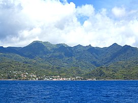
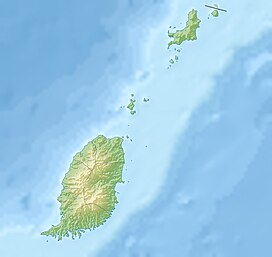
Mount Saint Catherine is an extensively weathered stratovolcano mountain and tallest peak on the Caribbean island of Grenada. Its summit marks the dividing line between the parishes of St. Mark and St. Andrew and is one of the highlights of the Mount St. Catherine Forest Reserve.
| Mount Saint Catherine | |
|---|---|
 Mount Saint Catherine | |
| Highest point | |
| Elevation | 840 m (2,760 ft) |
| Prominence | 840 m (2,760 ft) |
| Isolation | 127.49 km (79.22 mi) to Richmond Peak |
| Listing | Country high point |
| Coordinates | 12°09′44″N 61°40′30″W / 12.162281°N 61.675035°W |
| Geography | |
| Location | Saint Mark Parish, Grenada |
| Geology | |
| Mountain type | Stratovolcano |
| Last eruption | Unknown |
The Mt. St. Catherine massif is the youngest of the five volcanoes on the island.[1] The volcano has a ~1.5-km horseshoe-shaped crater open to the east, where a complex of volcanic lava domes occur across its flanks and is monitored by the Seismic Research Center of the University of the West Indies. The volcano is considered dormant because it has likely not erupted since the last Ice Age.[2] It is considered to be the only live volcano among the five volcanic centers in Grenada on account of its relatively well preserved morphology and the presence of hot springs and fumaroles on its flanks.[3] Although violent eruptions occurred in the geological past (i.e. Pleistocene—2,588,000 to 11,700 years ago), revealed by voluminous pyroclastic-flow deposits extending northwest of the summit, this type of volcanic activity is now considered unlikely to occur in the near future.[4]
The mountain summit is accessible by three steep rugged routes crossing the forest reserve, from Mt. Horne in the southeast, Mt. Kublal in the northeast, and Tufton Hall from the northwest. Tours are available, as well as guided trips to Tufton Hall Waterfall, the highest waterfalls on the island, off the southeastern flank of the mountain.

See also
editReferences
edit- ^ White, William; Copeland, Peter; Gravatt, Daniel R.; Devine, Joseph D. (2017). "Geochemistry and Geochronology of Grenada and Union Islands, Lesser Antilles: The Case for Mixing between Two Magma Series Generated from Distinct Sources". Geosphere. 13 (5): 1359–1391. doi:10.1130/GES01414.1.
- ^ Caribbean Conservation Association (1991). Grenada: Country Environmental Profile (PDF). Bridgetown, Barbados: Regional Development Office/Caribbean (USAID).
- ^ Benavente, Oscar; Urzua, Luis; Lovelock, Brian; Brookes, Alastair; Ussher, Greg (2015). "Grenada Geothermal Surface Exploration". Proceedings 37th New Zealand Geothermal Workshop. Taupo, New Zealand: Alastair.
- ^ Robertson, Richard E. A. (2005). "Grenada". In Lindsay, Jan M.; Robertson, Richard E. A.; Shepherd, John B.; Ali, Shahiba (eds.). In Volcanic Hazard Atlas of the Lesser Antilles. Trinidad and Tobago: University of the West Indies Seismic Research Unit. pp. 49–66. ISBN 978-976-95142-0-1.
