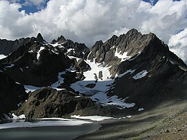
Mount Anderson is a 7,330-foot-high (2,234 m) peak in the Olympic Mountains of the Pacific Northwest. Rising in the center of Olympic National Park in Washington state, it is the second highest peak on the Anderson Massif, after West Peak.[3] Anderson Glacier used to be located in a cirque on the mountain's southern flank while Eel Glacier is in another cirque, northwest of the summit. Hanging Glacier is on the east side of a ridge which extends north from the peak.
| Mount Anderson | |
|---|---|
 Mount Anderson | |
| Highest point | |
| Elevation | 7,330 ft (2,234 m)[1] |
| Prominence | 721 ft (220 m)[2] |
| Coordinates | 47°43′16″N 123°19′54″W / 47.721145103°N 123.331641881°W[1] |
| Naming | |
| Etymology | Thomas M. Anderson |
| Geography | |
 | |
| Interactive map of Mount Anderson | |
| Location | Jefferson County, Washington, U.S. |
| Parent range | Olympic Mountains |
| Topo map | USGS Mount Steel |
Anderson is at the center of three major watersheds in the Olympic Range.[4] Most of the water which falls on the massif flows into the Dosewallips River which drains, by way of the Hood Canal, into Puget Sound. The drainage from the west side flows down the Quinault River and into the Pacific, while some of the water on the mountain's northwest side flows into the Hayes River which finds its way north, to the Strait of Juan de Fuca.[5]
Mount Anderson was named by army Lieutenant Joseph O'Neil for his commanding officer, Thomas M. Anderson.[6] It was first climbed in 1920 by Fairman B. Lee and a party of 13.[7]
Climate
editMount Anderson is located in the marine west coast climate zone of western North America.[8] Most weather fronts originate in the Pacific Ocean, and travel northeast toward the Olympic Mountains. As fronts approach, they are forced upward by the peaks of the Olympic Range, causing them to drop their moisture in the form of rain or snowfall (Orographic lift). As a result, the Olympics experience high precipitation, especially during the winter months in the form of snowfall.[8] During winter months, weather is usually cloudy, but, due to high pressure systems over the Pacific Ocean that intensify during summer months, there is often little or no cloud cover during the summer.
Geology
editThe Olympic Mountains are composed of obducted clastic wedge material and oceanic crust, primarily Eocene sandstone, turbidite, and basaltic oceanic crust.[9] The mountains were sculpted during the Pleistocene era by erosion and glaciers advancing and retreating multiple times.
See also
editReferences
edit- ^ a b "Anderson USGS 1955". NGS Data Sheet. National Geodetic Survey, National Oceanic and Atmospheric Administration, United States Department of Commerce. Retrieved 2008-11-28.
- ^ "Mount Anderson, Washington". Peakbagger.com. Retrieved 2008-11-28.
- ^ "Anderson Massif". Peakbagger.com.
- ^ "Mount Anderson (East Peak)". SummitPost.org.
- ^ Majors, Harry M. (1975). Exploring Washington. Van Winkle Publishing Co. p. 69. ISBN 978-0-918664-00-6. OCLC 214543162.
- ^ Evans, Gail H.E. (1983). "Chapter 1, Unknown no longer: Exploration". Historic resource study, Olympic National Park, Washington. National Park Service.
- ^ Olympic Mountain Rescue (2006). Olympic Mountains: A Climbing Guide. Mountaineers Books. p. 99. ISBN 978-0-89886-206-5. OCLC 62430882.
- ^ a b McNulty, Tim (2009). Olympic National Park: A Natural History. Seattle, Washington: University of Washington Press.
- ^ Alt, D.D.; Hyndman, D.W. (1984). Roadside Geology of Washington. pp. 249–259. ISBN 0-87842-160-2.
External links
edit- Mt. Anderson weather: Mountain Forecast
- "Mount Anderson (West Peak)". SummitPost.org.
- "West Peak, Washington". Peakbagger.com.

