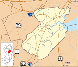
Morgan is a neighborhood in Sayreville in Middlesex County, in the U.S. state of New Jersey,[2][3][4][5] named for Charles Morgan III who purchased the land on May 7, 1710.[6][7]
Morgan, New Jersey | |
|---|---|
| Coordinates: 40°28′00″N 74°16′06″W / 40.46667°N 74.26833°W | |
| Country | |
| State | |
| County | Middlesex |
| Borough | Sayreville |
| Elevation | 66 ft (20 m) |
| GNIS feature ID | 878475[1] |
The Morgan Draw, constructed over the Cheesequake Creek in 1912, serves the North Jersey Coast Line.[8]
A month before the end of World War I in 1918, the neighborhood was heavily damaged by the T. A. Gillespie Company Shell Loading Plant explosion.[9][10]
Morgan Heights is a neighborhood on the bluff in the district.
See also
editReferences
edit- ^ a b "Morgan". Geographic Names Information System. United States Geological Survey, United States Department of the Interior.
- ^ Gannett, Henry (January 28, 1895). "A Geographic Dictionary of New Jersey". U.S. Government Printing Office – via Google Books.
- ^ Locality Search, State of New Jersey. Accessed February 11, 2015.
- ^ "NJDOT Graphic Information System Maps Middlesex" (PDF). New Jersey Department of Transportation. Retrieved March 2, 2020.
- ^ "Morgan Heights Sayreville, NJ 08879, Neighborhood Profile - NeighborhoodScout".
- ^ "Timeline".
- ^ James, Verne. "Morgan, New Jersey". Retrieved September 24, 2018.
- ^ "REHABILITATION PLANNED FOR 94-YEAR-OLD DRAWBRIDGE ON NORTH JERSEY COAST LINE" (Press release). New Jersey Transit. April 12, 2006. Retrieved September 22, 2018.
- ^ Yusko, Frank (1994). The Morgan Explosion of 1918. Milltown, NJ: Visionary Video Studios.
- ^ Gabrielan, Randall (2012). Explosion at Morgan: The World War I Middlesex Munitions Disaster. Charleston, SC: The History Press. ISBN 978-1-60949-517-6.
