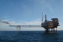
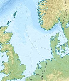
The Montrose oil field is a significant crude oil producing field in the UK sector of the central North Sea, 210 km east of Aberdeen. Production of oil started in 1976 and a major upgrade in 2016 extended the field life to beyond 2030.
| Montrose oil field | |
|---|---|
| Country | United Kingdom |
| Region | Central North Sea |
| Location/blocks | Blocks 22/17 and 22/18 |
| Offshore/onshore | Offshore |
| Coordinates | 57°27′02″N 01°23′16″E / 57.45056°N 1.38778°E |
| Operator | see text |
| Owner | see text |
| Field history | |
| Discovery | 1971 |
| Start of production | 1976 |
| Peak year | 1979 |
| Production | |
| Peak of production (oil) | 28,700 barrels per day (~1.4×10⁶ t/a) |
| Recoverable oil | 86.4 million barrels (~1.1×10⁷ t) |
| Producing formations | Palaeocene Sandstone |

The field
editThe Montrose oil field is located in Blocks 22/17 and 22/18 of the UK North Sea. It is named after the Scottish east coast town of Montrose. The field was discovered in November 1971 and is a Palaeocene sandstone at a depth of 8,000 feet (2,438 m).[1] The reservoir has the following characteristics:[2][3]
| Parameter | Value |
|---|---|
| API gravity | 38.5-40° |
| Gas Oil Ratio | 600-700 scf/bbl |
| Porosity | 22.8% |
| Permeability | 39.3 md |
| Pressure | 3,750 psi at 8,150 TVDSS |
| Sulfur | 0.23% |
| Recoverable reserves | 86.4 million barrels
12.8 million tonnes |
Owners and operators
editThe field was originally licensed to a joint venture comprising Amoco UK Petroleum Limited (30.77%), Enterprise Oil plc (30.77%), Amerada Hess Exploration Ltd (23.00%), and Texas Eastern (UK) Ltd (15.38%).[2] The field was originally operated by Amoco (UK) Exploration Company.[2][3][4] Ownership of the Montrose field passed from Amoco to BP to Paladin Resources, until Talisman Energy took over in 2012 and most recently Repsol bought the assets in joint ownership with Sinopec. In late 2023 Sinopec sold their share and it is now owned solely by Repsol Resources.[3]
Development
editThe field was developed by a single integrated production platform Montrose Alpha (or Montrose A). Oil was initially exported through a pair of CALM buoys located 1.7 km from the platform.[2] In 1982 a 48 km 14-inch oil pipeline from Montrose to Forties Charlie was commissioned which provided an oil export route.[2]
| Installation | Montrose A | Montrose bridge linked platform | CALM buoys |
|---|---|---|---|
| Coordinates | 57°27'02"N 01°23'16"E | ||
| Water depth, metres | 88 | 88 | 91 |
| Fabrication | UIE Cherbourg and St. Wandrille | Heerema Fabrication, Zwijndrecht Netherlands | Earl Wright Newcastle |
| Topside weight, tonnes | 14,000 | 10,500 | |
| Function | Drilling, production, accommodation | Process and utilities | Offloading oil |
| Accommodation | 96 | – | – |
| Type | Steel jacket | Steel jacket | Catenary anchor leg |
| Legs | 8 | 4 | – |
| Piles | 32 | 6 | – |
| Well slots | 24 | – | – |
| Throughput oil, bpd | 60,000 | 40,000 | 60,000 |
| Oil storage capacity, barrels | Nil | Nil | – |
| Installed | 1975 | 2016 | 1975 |
| Production start | June 1976 | 2016 | 1976 |
| Oil production to | CALM buoys
Forties Charlie 48 km 14-inch |
Montrose A (bridge) | Tankers 72,000 dwt |
| Gas production to | Flare | Montrose A (bridge) | – |
Production
editThe original processing plant on Montrose A had a nominal capacity of 60,000 barrels of oil per day. Water injection was 55,000 barrels per day. There were 16 production wellheads, and 4 water injection wells. The production of oil (in 1000s barrels) was:[2]
Graphs are unavailable due to technical issues. There is more info on Phabricator and on MediaWiki.org. |
There were two Catenary Anchor Leg Mooring (CALM) buoys in 91 metres of water. They were used from 1976 to 1984 to load tankers. They were decommissioned in 1984 when the 48 km 14-inch oil export line from Montrose to Forties Charlie was commissioned.[2]
Montrose was a 'stranded asset' with no nearby export route for gas, the gas was therefore flared. A horizontal 455 feet (139 m) long flare bridge was installed between the platform and the flare (57.451336N 1.390825E). The bridge was supported by a tripod jacket.
Redevelopment
editIn 1990, Amoco modified the Montrose A processing equipment to receive oil from the then new Arbroath field integrated drilling and production platform. The discovery of the Wood oil field entailed the installation of the Wood and Gas Export (WaGE) processing and compression module on Montrose A and a new 6-inch pipeline delivered gas into the CATS offshore pipeline on Arbroath.[3]
Three new fields – Godwin, Cayley and Shaw – were discovered in the Montrose area. Additional process facilities were required to develop these fields. Details of the field were as follows:[3][5]
| Name | Block | Discovered | Location | Water depth | Developed | Start-up |
|---|---|---|---|---|---|---|
| Cayley | 22/17 | 2007 | 10 km west of Montrose | 91 m | 2 subsea production | June 2017 |
| Shaw | 22/22 | 2009 | 17 km north of Montrose | 3 subsea production, 2 injection | May 2017 | |
| Wood | 22/18 | 1996 | 10 km south east of Montrose | 92 m | 1 subsea well | December 2007 |
A new platform was installed adjacent to Montrose A in 2016. This was known as the bridge-linked platform and provided additional process and plant support facilities. Production increased to 40,000 boe (barrels of oil equivalent) per day.[5]
References
edit- ^ Crawford, R., R. W. Littlefair and L. G. Affleck (1 January 1991). "The Arbroath and Montrose Fields, Blocks 22/17, 18, UK North Sea". Geological Society, London, Memoirs. 14: 211–17. doi:10.1144/GSL.MEM.1991.014.01.26. S2CID 128684619.
{{cite journal}}: CS1 maint: multiple names: authors list (link) - ^ a b c d e f g Oilfield Publications Limited (1985). The North Sea Platform Guide. Ledbury: Oilfield Publications Limited. pp. 521–511.
- ^ a b c d e "Twin-platform complex to maximize Montrose Area resources". Offshore magazine. 11 August 2016. Retrieved 14 October 2021.
- ^ Department of Trade and Industry (1994). The Energy Report. London: HMSO. pp. 73 and map 9. ISBN 0115153802.
- ^ a b "New Montrose platform successfully installed". repsolsinopecuk.com. 2016. Retrieved 14 October 2021.
