Mikulášovice (German: Nixdorf) is a town in Děčín District in the Ústí nad Labem Region of the Czech Republic. It has about 2,100 inhabitants.
Mikulášovice | |
|---|---|
 Church of Saint Nicholas | |
 Flag  Coat of arms | |
 Mikulášovice Location in the Czech Republic | |
| Coordinates: 50°57′56″N 14°21′28″E / 50.96556°N 14.35778°E | |
| Country | |
| Region | Ústí nad Labem |
| District | Děčín |
| First mentioned | 1449 |
| Government | |
| • Mayor | Aleš Jandus |
| Area | |
| • Total | 25.85 km2 (9.98 sq mi) |
| Elevation | 414 m (1,358 ft) |
| Population (2024-01-01)[1] | |
| • Total | 2,077 |
| • Density | 80/km2 (210/sq mi) |
| Time zone | UTC+1 (CET) |
| • Summer (DST) | UTC+2 (CEST) |
| Postal code | 407 79 |
| Website | www |
Administrative parts
editThe villages of Mikulášovičky, Salmov and Tomášov are administrative parts of Mikulášovice.
Geography
editMikulášovice is located about 23 kilometres (14 mi) northeast of Děčín and 40 km (25 mi) northeast of Ústí nad Labem. It lies in the salient region of Šluknov Hook, on the border with Germany, adjacent to the municipal territory of Sebnitz.
Mikulášovice lies in the Lusatian Highlands. The highest point is the mountain Tanečnice at 598 m (1,962 ft) above sea level. The town is situated in the elongated valley of the brook Mikulášovický potok.
History
editThe first written mention of Mikulášovice is from 1446. The village was founded in the 12th century. In the 18th century, it was already an industrial municipality with tradition in knives sharpening. In 1794, the production of knives began.[2]
From 1938 to 1945 it was occupied by Germany, before it was liberated by Polish soldiers in May 1945 and restored to Czechoslovakia. In the final stages of World War II, in May 1945, the prisoners of the AL Bautzen subcamp of the Gross-Rosen concentration camp, evacuated from Bautzen to Mikulášovice by the Germans, were liberated there by Polish soldiers.[3]
Demographics
edit
|
|
| ||||||||||||||||||||||||||||||||||||||||||||||||||||||
| Source: Censuses[4][5] | ||||||||||||||||||||||||||||||||||||||||||||||||||||||||
Economy
editThe company Mikov, producing the popular knife Rybička, has its seat in Mikulášovice.
Transport
editThe town is served by three train stations. The station Mikulášovice dolní nádraží on the railway line Děčín–Rumburk is located just behind the municipal border. The stations Mikulášovice horní nádraží and Mikulášovice střed are on the line Rumburk–Mikulášovice dolní nádraží, but trains run on it only on weekends and holidays during the summer season.[6]
Sights
edit
The main landmark of Mikulášovice is the Church of Saint Nicholas. It was built in the late Baroque style in 1750–1751.[7]
On the Tanečnice hill is an eponymous observation tower. The first wooden observation tower was built here in 1885. The current stone tower dates from 1905. It is 26 m (85 ft) high.[8]
Notable people
edit- Franz Dittrich (1815–1859), pathologist
- Anni Frind (1900–1987), soprano opera singer
- Oskar Schäfer (1921–2011), Knight's Cross holder
Gallery
edit-
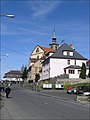 Town hall and Church of Saint Nicholas
 -
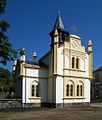 Church of the Ascension of Jesus


References
edit- ^ "Population of Municipalities – 1 January 2024". Czech Statistical Office. 2024-05-17.
- ^ "Z historie města" (in Czech). Město Mikulášovice. Retrieved 2021-07-14.
- ^ "Subcamps of KL Gross- Rosen". Gross-Rosen Museum in Rogoźnica. Retrieved 2020-06-14.
- ^ "Historický lexikon obcí České republiky 1869–2011 – Okres Děčín" (in Czech). Czech Statistical Office. 2015-12-21. pp. 11–12.
- ^ "Population Census 2021: Population by sex". Public Database. Czech Statistical Office. 2021-03-27.
- ^ "Detail stanice Mikulášovice dol.n." (in Czech). České dráhy. Retrieved 2024-07-10.
- ^ "Kostel sv. Mikuláše" (in Czech). National Heritage Institute. Retrieved 2023-05-29.
- ^ "O rozhledně Tanečnice". Rozhledna Tanečnice (in Czech). Retrieved 2023-05-29.