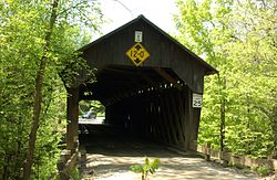
The Martin's Mill Covered Bridge is a wooden covered bridge spanning Lull's Brook on Martinsville Road in Hartland, Vermont. Built about 1880, it is one of two surviving 19th-century covered bridges in the town. It was listed on the National Register of Historic Places in 1973.[1]
Martin's Mill Covered Bridge | |
 | |
| Location | Martinsville Rd., Hartland, Vermont |
|---|---|
| Coordinates | 43°31′56″N 72°23′47″W / 43.53222°N 72.39639°W |
| Area | 1 acre (0.40 ha) |
| Built | 1880 |
| Built by | Tasker, James F. |
| Architectural style | Town lattice truss |
| NRHP reference No. | 73000213[1] |
| Added to NRHP | August 28, 1973 |
Description and history
editThe Martin's Mill Covered Bridge is located about 0.6 miles (0.97 km) east of United States Route 5 on Martinsville Road in a rural wooded area of southern Hartland, with the highway bridges of Interstate 91 rising just to its east. The bridge is a single span Town lattice truss, resting on concrete abutments. It is 136 feet (41 m) long, with portals overhanging the ends by 4 feet (1.2 m). Its total width is 19.5 feet (5.9 m), with a roadway width of 16.5 feet (5.0 m) (one lane). The exterior of the bridge is clad in vertical board siding, which wraps around for a short distance on the insides of the portals. The roof is metal.[2]
The bridge was built about 1880 by James Tasker, who covered bridge historian R.S. Allen describes as one of the most prolific bridgewrights in Windsor County. Tasker most often built bridges that were a modified version of a kingspost truss; this bridge is the more common Town lattice style. It is, along with the Willard Covered Bridge, one of two surviving 19th-century covered bridges in Hartland.[2]
See also
editReferences
edit- ^ a b "National Register Information System". National Register of Historic Places. National Park Service. July 9, 2010.
- ^ a b Hugh Henry (1973). "NRHP nomination for Martin's Mill Covered Bridge". National Park Service. Retrieved 2016-07-30. with photos from 1973
