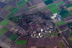
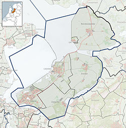
Marknesse is a village in the Dutch province of Flevoland. It is a part of the municipality of Noordoostpolder, and lies about 7.5 kilometres (4.7 mi) east of Emmeloord.
Marknesse | |
|---|---|
 Marknesse from above | |
Location of Marknesse in the province of Flevoland | |
| Coordinates: 52°42′32″N 5°51′44″E / 52.70889°N 5.86222°E | |
| Country | Netherlands |
| Province | Flevoland |
| Municipality | Noordoostpolder |
| Established | 1946 |
| Area | |
• Total | 53.82 km2 (20.78 sq mi) |
| Elevation | −2.8 m (−9.2 ft) |
| Population (2021)[1] | |
• Total | 3,775 |
| • Density | 70/km2 (180/sq mi) |
| Time zone | UTC+1 (CET) |
| • Summer (DST) | UTC+2 (CEST) |
| Postal code | 8316[1] |
| Dialing code | 0527 |
| Website | www |
History
editMarknesse was first mentioned in 1950 as Marknesse, and is a combination of border land and headland. It has been named after a flooded village near Urk.[3]
The village was founded in 1946 as B. In 1943, temporary barracks were built to polder the Noordoostpolder. The plan of the village by Theo Verlaan was approved in 1949. The village has a green central axis with the Dutch Reformed Church in one corner and the Reformed Church on the other side, and the flanks contain shops. Most of the houses are oriented north–south.[4]
After the merger of the two Reformed Churches into the Protestant Church, it was decided to demolish the Dutch Reformed church and replace it with a five-story apartment building.[5] One of the original wooden barracks is still present. It was supposed to be transformed into residential houses, but is currently in use as a cultural centre.[5]
Gallery
edit-
Marknesse, reformed church
-
Farm in Marknesse
-
Field of flowers
-
Catholic church
Climate
edit| Climate data for Marknesse (1991−2020 normals, extremes 1989−present) | |||||||||||||
|---|---|---|---|---|---|---|---|---|---|---|---|---|---|
| Month | Jan | Feb | Mar | Apr | May | Jun | Jul | Aug | Sep | Oct | Nov | Dec | Year |
| Record high °C (°F) | 14.5 (58.1) |
17.6 (63.7) |
23.4 (74.1) |
28.5 (83.3) |
31.3 (88.3) |
33.7 (92.7) |
38.1 (100.6) |
34.7 (94.5) |
31.2 (88.2) |
25.5 (77.9) |
19.1 (66.4) |
14.3 (57.7) |
38.1 (100.6) |
| Mean daily maximum °C (°F) | 5.3 (41.5) |
6.1 (43.0) |
9.6 (49.3) |
14.3 (57.7) |
17.9 (64.2) |
20.2 (68.4) |
22.4 (72.3) |
22.4 (72.3) |
18.9 (66.0) |
14.2 (57.6) |
9.2 (48.6) |
6.0 (42.8) |
13.9 (57.0) |
| Daily mean °C (°F) | 3.1 (37.6) |
3.4 (38.1) |
5.9 (42.6) |
9.5 (49.1) |
13.1 (55.6) |
15.6 (60.1) |
17.7 (63.9) |
17.5 (63.5) |
14.4 (57.9) |
10.5 (50.9) |
6.6 (43.9) |
3.8 (38.8) |
10.1 (50.2) |
| Mean daily minimum °C (°F) | 0.8 (33.4) |
0.7 (33.3) |
2.4 (36.3) |
4.6 (40.3) |
8.2 (46.8) |
10.7 (51.3) |
12.7 (54.9) |
12.6 (54.7) |
10.1 (50.2) |
6.8 (44.2) |
3.9 (39.0) |
1.5 (34.7) |
6.2 (43.2) |
| Record low °C (°F) | −16.7 (1.9) |
−22.8 (−9.0) |
−20.7 (−5.3) |
−6.0 (21.2) |
−0.5 (31.1) |
1.7 (35.1) |
5.0 (41.0) |
5.4 (41.7) |
2.3 (36.1) |
−5.3 (22.5) |
−8.4 (16.9) |
−13.0 (8.6) |
−22.8 (−9.0) |
| Average precipitation mm (inches) | 66.8 (2.63) |
55.1 (2.17) |
49.9 (1.96) |
41.2 (1.62) |
58.2 (2.29) |
77.1 (3.04) |
87.0 (3.43) |
85.8 (3.38) |
71.7 (2.82) |
73.2 (2.88) |
66.9 (2.63) |
71.9 (2.83) |
804.8 (31.69) |
| Average relative humidity (%) | 90.0 | 87.5 | 83.4 | 77.0 | 75.6 | 79.2 | 80.2 | 81.0 | 85.0 | 88.4 | 91.4 | 91.3 | 84.2 |
| Mean monthly sunshine hours | 68.8 | 97.0 | 149.0 | 200.2 | 226.5 | 214.2 | 224.6 | 205.4 | 159.9 | 121.8 | 70.0 | 60.6 | 1,798 |
| Percent possible sunshine | 26.9 | 34.7 | 40.4 | 47.9 | 46.4 | 42.6 | 44.4 | 45.0 | 41.9 | 36.8 | 26.5 | 25.3 | 38.2 |
| Source: Royal Netherlands Meteorological Institute[6][7] | |||||||||||||
References
edit- ^ a b c "Kerncijfers wijken en buurten 2021". Central Bureau of Statistics. Retrieved 12 April 2022.
- ^ "Postcodetool for 8316AA". Actueel Hoogtebestand Nederland (in Dutch). Het Waterschapshuis. Retrieved 12 April 2022.
- ^ "Marknesse (geografische naam)". Etymologiebank (in Dutch). Retrieved 12 April 2022.
- ^ Ronald Stenvert & Chris Kolman (2006). "Marknesse" (in Dutch). Zwolle: Waanders. ISBN 90 400 9179 X. Retrieved 12 April 2022.
- ^ a b "Marknesse". Plaatsengids (in Dutch). Retrieved 12 April 2022.
- ^ "Weerstatistieken Marknesse". Royal Netherlands Meteorological Institute. Retrieved June 25, 2022.
- ^ "Klimaatviewer 1991-2020". Royal Netherlands Meteorological Institute. Retrieved June 25, 2022.
External links
edit- Media related to Marknesse at Wikimedia Commons


