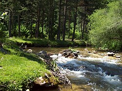
The Malka Arda (Bulgarian: Малка Арда) is a 41 km long river in southern Bulgaria, a left tributary of the Arda of the Maritsa drainage.[1]
| Malka Arda | |
|---|---|
 | |
 | |
| Location | |
| Country | Bulgaria |
| Physical characteristics | |
| Source | |
| • location | Momina Voda locality, Rhodope Mountains |
| • coordinates | 41°42′12.96″N 24°48′11.16″E / 41.7036000°N 24.8031000°E |
| • elevation | 1,716 m (5,630 ft) |
| Mouth | |
• location | Arda→ Maritsa→ Aegean Sea |
• coordinates | 41°32′23.04″N 25°4′23.16″E / 41.5397333°N 25.0731000°E |
• elevation | 488 m (1,601 ft) |
| Length | 41 km (25 mi) |
| Basin size | 142 km2 (55 sq mi) |
The river takes its source under the name Mrazliv Dol at an altitude of 1,716 m in the Momuna Voda locality in the Pereliksko–Prespanski Ridge of the western Rhodope Mountains, north of the Momchul Yunak refuge. It flows in a deep narrow valley in direction southeast until the village of Slaveyno, after which it turns south–southeast for the rest of its length. Near the village of Banite, the river passes through a small valley extension, after which its valley becomes canyon-like and difficult to access, with numerous meanders along the mountain slopes. It flows into the Arda at an altitude of 488 m some 2 km south of the village of Galabovo.[1] It drains the southeastern slopes of the Pereliksko–Prespanski Ridge.[1]
Its drainage basin covers a territory of 142 km2, or 2.45% of the Arda's total.[1] The river has predominantly rain–snow feed with high water in January and low water in August. The average annual flow at Banite is 2.11 m3/s.[1]
The Malka Arda flows entirely in Smolyan Province. There are six villages along its course — Kutela, Slaveyno and Petkovo in Smolyan Municipality, and Malka Arda, Oryahovets and Banite in Banite Municipality. There are hot mineral springs at Banite.[1]
A 14.3 km stretch of the third class III-863 road Sokolovtsi–Slaveyno–Banite follows its valley between the latter two villages.[2]
Citations
edit- ^ Jump up to: a b c d e f Geographic Dictionary of Bulgaria 1980, p. 301
- ^ "A Map of the Republican Road Network of Bulgaria". Official Site of the Road Infrastructure Agency. Retrieved 3 May 2024.
References
edit- Мичев (Michev), Николай (Nikolay); Михайлов (Mihaylov), Цветко (Tsvetko); Вапцаров (Vaptsarov), Иван (Ivan); Кираджиев (Kiradzhiev), Светлин (Svetlin) (1980). Географски речник на България [Geographic Dictionary of Bulgaria] (in Bulgarian). София (Sofia): Наука и култура (Nauka i kultura).
