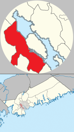
Mainland Halifax is the remaining portion of the community of Halifax, without the Halifax Peninsula.
Mainland Halifax | |
|---|---|
 Location of Mainland Halifax in Halifax Regional Municipality | |
| Coordinates: 44°37′45.9″N 63°36′19.5″W / 44.629417°N 63.605417°W | |
| Country | |
| Province | |
| Municipality | Halifax Regional Municipality |
| Founded | 1996 |
| Communities and neighbourhoods | Armdale, Bayers Lake, Boulderwood, Bridgeview, Clayton Park, Clayton Park West, Cowie Hill, Fairmount, Fairview, Green Acres, Leiblin Park, Melville Cove, Rockingham, Purcell's Cove, Sherwood Heights, Spryfield, Wedgewood, Williams Lake |
| Government | |
| • Type | Municipal council |
| Area | |
| • Land | 43.012 km2 (16.607 sq mi) |
| Population | |
| • Total | 83,972 |
| • Density | 1,952/km2 (5,060/sq mi) |
| Time zone | UTC-4 (AST) |
| Area code(s) | 782, 902 |
| Places in Nova Scotia | |
History
editFor thousands of years and currently, Mainland Halifax has been be on the unceded ancestral lands of the Mi'kmaq.
On 21 June 1749, the Town of Halifax was founded. Europeans began to colonize the area, and sometime between 1841 and 1842, Halifax was granted city status. Between 1841 and 1842 and 1969, Halifax expanded to become the entire Halifax Peninsula.
In 1969, Halifax annexed several communities from Halifax County, and they were located in what would become the area of Mainland Halifax; Armdale, Clayton Park, Fairview, Rockingham, Purcell's Cove and Spryfield.
On 1 April 1996, the City of Dartmouth, the City of Halifax, the County of Halifax, and the Town of Bedford amalgamated and created the Halifax Regional Municipality. Subsequently, the entirety of the former City of Halifax was re-established as the Community of Halifax and is coterminous with the former city itself. However, the new community was divided into two subsections: Mainland Halifax and Peninsular Halifax.
Currently, Mainland Halifax enjoys increased cultural, demographic, and economic growth from its great location. It hosts busy communities that make this a fantastic area within the municipality.
Geography
editMainland Halifax is portioned into two sections, Mainland North and Mainland South, divided by St. Margaret's Bay Road. The area of Mainland Halifax has a landmass of 4,301.2 hectares (43.012 km2).
Communities and neighbourhoods
editMainland North
edit- Armdale
- Bayer's Lake
- Bridgeview
- Clayton Park
- Clayton Park West
- Fairmount
- Rockingham
- Sherwood Heights
- Wedgewood
Mainland South
edit- Boulderwood
- Cowie Hill
- Green Acres
- Leiblin Park
- Melville Cove
- Purcell's Cove
- Spryfield
- Williams Lake
Topography
editThe area lies west of the Bedford Basin and Northwest Arm and extends several kilometres inland.
Demographics
editMainland Halifax's population as of 2021 was 83,972 people, an increase of 10,662 people (over 14.5%) from 73,310 people in 2016.
The area's population density increased by 248 people per km2, from approximately 1,704 people per km2 in 2016 to approximately 1,952 people per km2 in 2021.
| Census Tract | Land area (km2) | Population (2021)[5] | Population (2016)[6] | Population Density (people per km2) (2021) | Population Change (%) |
|---|---|---|---|---|---|
| 2050001.00 | 5.703 | 4,123 | 3,868 | 722 | 6.5 |
| 2050002.00 | 11.518 | 8,358 | 6,194 | 725 | 34.9 |
| 2050014.00 | 1.838 | 4,390 | 4,248 | 2,388 | 3.3 |
| 2050015.00 | 2.042 | 5,389 | 4,829 | 2,639 | 15.9 |
| 2050016.00 | 2.563 | 4,021 | 3,766 | 1,568 | 6.7 |
| 2050017.00 | 2.912 | 2,999 | 2,914 | 1,029 | 2.9 |
| 2050024.00 | 2.181 | 8,618 | 7,375 | 3,951 | 16.8 |
| 2050025.01 | 1.05 | 5,201 | 4,726 | 4,953 | 10 |
| 2050025.02 | 1.913 | 5,515 | 4,863 | 2,882 | 13.4 |
| 2050025.04 | 0.911 | 4,818 | 4,685 | 5,288 | 2.8 |
| 2050025.05 | 1.556 | 3,746 | 3,547 | 2,407 | 5.6 |
| 2050026.02 | 1.509 | 4,855 | 3,409 | 3,217 | 42.4 |
| 2050026.03 | 1.393 | 3,348 | 3,358 | 2,403 | 0.3 |
| 2050026.04 | 0.654 | 4,346 | 4,199 | 6,645 | 3.5 |
| 2050026.05 | 0.771 | 3,866 | 3,967 | 5,014 | 2.5 |
| 2050027.00 | 4.498 | 10,379 | 7,362 | 2,307 | 40.9 |
| Mainland Halifax | 43.012 | 83,972 | 73,310 | 1,952 | 14.5 |
| Year | Pop. | ±% |
|---|---|---|
| 2016 | 73,310 | — |
| 2021 | 83,972 | +14.5% |
References
edit- ^ "Census 2021 Census Tracts". HRM Open Data. Government of the Municipality of Halifax. Retrieved 10 August 2022.
- ^ "Census 2016 Census Tracts". HRM Open Data. Government of the Municipality of Halifax. Retrieved 10 August 2022.
- ^ "Census 2021 Census Tracts". HRM Open Data. Government of the Municipality of Halifax. Retrieved 10 August 2022.
- ^ "Census 2016 Census Tracts". HRM Open Data. Government of the Municipality of Halifax. Retrieved 10 August 2022.
- ^ "Census 2021 Census Tracts". HRM Open Data. Government of the Municipality of Halifax. Retrieved 10 August 2022.
- ^ "Census 2016 Census Tracts". HRM Open Data. Government of the Municipality of Halifax. Retrieved 10 August 2022.
