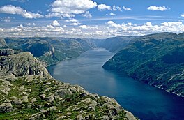
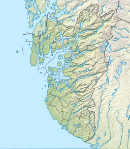
Lysefjord or Lysefjorden[1] is a fjord located in the Ryfylke area in Rogaland county in southwestern Norway. The 42-kilometre (26 mi) long fjord lies in the municipalities of Strand and Sandnes, about 25 kilometres (16 mi) east of the city of Stavanger.
| Lysefjorden | |
|---|---|
| Lysefjord | |
 View of the fjord | |
| Location | Rogaland county, Norway |
| Coordinates | 58°56′26″N 6°07′13″E / 58.9405°N 6.1202°E |
| Primary inflows | Lyseåna river |
| Primary outflows | Høgsfjorden |
| Basin countries | Norway |
| Max. length | 42 kilometres (26 mi) |
| Max. width | 1.75 kilometres (1.09 mi) |
| Max. depth | −422 metres (−1,385 ft) |
| Settlements | Lysebotn, Forsand, Oanes |
The name means light fjord, and is said to be derived from the lightly coloured granite rocks along its sides. It is particularly well known for the huge Preikestolen cliff overlooking the fjord, which is a major tourist destination for the region. The fairly isolated village of Lysebotn lies at the eastern end of the fjord and the villages of Forsand and Oanes both lie at the western end of the fjord near the Lysefjord Bridge, the only crossing of the fjord.[2]
Geology
editThe fjord was carved by the action of glaciers in the ice ages and was flooded by the sea when the later glaciers retreated. The geology of Lysefjorden was thoroughly investigated and described by Professor Bjørn G. Andersen in his Master's thesis (1954) "Om isens tilbaketrekking i området mellom Lysefjorden og Jøsenfjorden i Ryfylke" (On the glacial retreat in the area between the Lysefjord and the Jøsenfjord in Ryfylke).[3]
End to end, it measures 42 kilometres (26 mi) with rocky walls falling nearly vertically over 1,000 metres (3,300 ft) into the water. Not only is the fjord long and narrow, it is in places as deep as the mountains are high. Starting at a depth of only 13 metres (43 ft) deep where it meets the sea near Forsand village, the Lysefjord then heads inland and drops to a depth of over 400 metres (1,300 ft) below the Preikestolen.
Population
editBecause of the inhospitable, mountainous terrain, the fjord is only lightly populated and only has two villages on its length - Forsand and Lysebotn, located at opposite ends of the fjord. There is a small farming area on the north shore of the fjord, about halfway between the two ends. That farm area is accessible by road from the village of Årdal over the mountains to the north. There are a few other very small, scattered settlements along the fjord, but those are only accessible by boat along the fjord. There are no roads along the fjord since the sides of the fjord are too steep for roads.
Lysebotn, at the far eastern end of the fjord, is largely populated by workers at the nearby hydroelectric plants at Lyse and Tjodan, both built inside the mountains. At the Lyse plant, the water falls 620 metres (2,030 ft) to the turbines, producing up to 210,000 kilowatts (280,000 hp) of electricity. At Tjodan, the water falls 896 metres (2,940 ft) to yield an output of 110,000 kilowatts (150,000 hp). The two power plants provide electricity for more than 100,000 people. A spectacular road which rises almost 900 metres (3,000 ft) through a series of 27 hairpin bends including a long hairpin tunnel inside the mountain is the only road access to Lysebotn from the outside world.
Gallery
edit-
Lysefjord from the top of Preikestolen
-
Lysefjord from Kjerag mountain
-
Lysefjord from Lysebotn
-
Lysefjorden looking west
-
View of Lysebotn, looking west
-
Looking over the cliff at Kjerag
-
Lysefjorden, Rogaland fylke
-
Panorama of Lysefjord with Preikestolen at the right of the image
Tourism
editLysefjorden is an extremely popular tourist attraction and day trip from the nearby city of Stavanger, from where cruise ships travel the full distance of the fjord. As well as the extraordinary scenery of the fjord itself, two points along its length are popular side trips. The towering cliff of Preikestolen, located above the fjord with a vertical drop of 604 metres (1,982 ft),[4] can be seen from the fjord, but is more impressive from above. At the end of the fjord lies the 1,110-metre (3,640 ft) tall Kjerag mountain, a popular hiking destination with even more spectacular drops. The Kjeragbolten is a famous boulder located at the Kjerag mountain. BASE jumping is legally allowed along the cliffs of the fjord.
Toilers of the Sea
editFrench writer Victor Hugo wrote the novel, Toilers of the Sea, in which he admires the scenery of the fjord after a visit here in 1866.
Nowhere do these terrific forces appear more formidably conjoined than in the surprising strait known as the Lyse-Fiord. The Lyse-Fiord is the most terrible of all the gut rocks of the ocean. Their terrors are there complete. It is in the northern sea, near the inhospitable Gulf of Stavanger, and in the 59th degree of latitude. The water is black and heavy, and subject to intermitting storms. In this sea, and in the midst of this solitude, rises a great sombre street--a street for no human footsteps. None ever pass through there; no ship ever ventures in. It is a corridor ten leagues in length, between two rocky walls of three thousand feet in height. Such is the passage which presents an entrance to the sea. The defile has its elbows and angles like all these streets of the sea--never straight, having been formed by the irregular action of the water.
— Victor Hugo, Toilers of the Sea[5]
See also
editReferences
edit- ^ The suffix "-en" is a form of the definite article in the Norwegian language
- ^ Store norske leksikon. "Lysefjorden" (in Norwegian). Retrieved 2016-02-18.
- ^ Andersen, Bjørn G. (1954). "Randmorener i Sørvest-Norge". Norsk Geografisk Tidsskrift - Norwegian Journal of Geography. 14 (5–6): 273–342. doi:10.1080/00291955408542734.
- ^ http://up.wiki.x.io/wikipedia/commons/6/6d/Preikestolen_Map.jpg [bare URL image file]
- ^ Toilers of the Sea. Retrieved 2016-02-18.
External links
edit- Lysefjord
- http://www.ryfylke.com
- Lysefjord and Lysebotn
- Lysefjorden Turist information
- Webcam from Lysefjorden
- Lysefjord Map Handy Map with comprehensive Trip explanation

