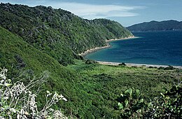
Long Island is located in Queen Charlotte Sound, one of the Marlborough Sounds of New Zealand.[1] James Cook recorded its original name as Hamote.[2]
 | |
 | |
| Geography | |
|---|---|
| Location | Marlborough Region |
| Coordinates | 41°06′49.67″S 174°17′4.32″E / 41.1137972°S 174.2845333°E |
| Area | 1.41 km2 (0.54 sq mi) |
| Length | 4 km (2.5 mi) |
| Width | 1 km (0.6 mi) |
| Highest elevation | 152 m (499 ft) |
| Administration | |
Department of Conservation (New Zealand) | |
| Demographics | |
| Population | 0 |
The island is long and thin - just over 1.41 square kilometres (0.54 sq mi) in area with a length of 4 km (2.5 mi) (the long axis being aligned north-east to south-west) and a maximum width of 1 km (0.62 mi). It was reserved for public utility on 26 March 1926 and soon after became a farm which ran between 300 and 400 sheep until 14 January 1926 when the island became a scenic reserve.[3] With the removal of stock in the 1930s the island has been left to regenerate back into native bush.
In April 1993, the Long Island-Kokomohua Marine reserve was created around Long island and the tiny Kokomohua islands off its northern tip.[4] It extends 460 metres (1,510 ft) offshore from the high water mark around the islands and was the first Marine reserve to be created in the South Island.[1] The island itself is also an important wildlife refuge and a number of species of threatened endemic birds which have been reintroduced to it including little spotted kiwi (late 1980s), yellow-crowned parakeet (2001) and South Island saddleback (2005) - all these reintroductions have been successful with healthy breeding populations of each species now present on the Island.[5][6]

See also
editReferences
edit- ^ a b "Long Island - Kokomohua Marine Reserve". Department of Conservation (New Zealand). Retrieved 4 March 2020.
- ^ "Cook's First Voyage". pacific.pitt.edu. Retrieved 18 January 2022.
- ^ "Wartime relics and spooky submarine stations rediscovered on Sounds voyage". Stuff. 28 November 2019. Retrieved 18 January 2022.
- ^ "Marine Reserve (Long Island—Kokomohua) Order 1993". Parliamentary Council Office. Retrieved 4 March 2020.
- ^ P. D Gaze; Bill Cash (2008). A history of wildlife translocations in the Marlborough Sounds (PDF). Vol. 72. Department of Conservation. pp. 1–25. ISBN 978-0-478-14293-8. ISSN 0113-3853. OCLC 1178912174. Wikidata Q104836742. Archived from the original (PDF) on 22 January 2021.
{{cite book}}:|journal=ignored (help) - ^ "Long Island". www.marlboroughonline.co.nz. Retrieved 18 January 2022.
41°06′49.67″S 174°17′4.32″E / 41.1137972°S 174.2845333°E