Littlestown is a borough in Adams County, Pennsylvania, United States. The population was 4,782 at the 2020 census.
Littlestown, Pennsylvania | |
|---|---|
Borough | |
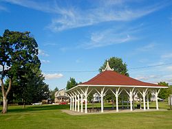
 Pavillon in Crouse Park | |
| Motto(s): We're growing, one neighbor at a time | |
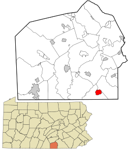
 Location in Adams County and the U.S. state of Pennsylvania. | |
| Coordinates: 39°44′37″N 77°05′21″W / 39.74361°N 77.08917°W | |
| Country | United States |
| State | Pennsylvania |
| County | Adams |
| Settled | 1765 |
| Incorporated | 1864 |
| Government | |
| • Type | Borough Council |
| • Mayor | Jennifer Beskid, EdD |
| Area | |
| • Total | 1.50 sq mi (3.89 km2) |
| • Land | 1.50 sq mi (3.89 km2) |
| • Water | 0.00 sq mi (0.00 km2) |
| Elevation | 627 ft (191 m) |
| Population | |
| • Total | 4,782 |
| • Density | 3,181.64/sq mi (1,228.55/km2) |
| Time zone | UTC-5 (Eastern (EST)) |
| • Summer (DST) | UTC-4 (EDT) |
| Zip Code | 17340 |
| Area codes | 717 and 223 |
| FIPS code | 42-43944 |
| Website | www |
Originally laid out by Peter Klein in 1760, the town was first named Petersburg. German settlers in the area came to call the town Kleine Stedtle. In 1795, as confusion between the town and a neighboring town, also named Petersburg and now named York Springs[3]) was growing, the town changed its name to Littlestown, an English translation of the German name Kleine Stedtle.[4]
Geography
editLittlestown is located at 39°44′37″N 77°5′21″W / 39.74361°N 77.08917°W (39.743749, -77.089240).[5] According to the U.S. Census Bureau, the borough has a total area of 1.6 square miles (4.1 km2), all land. Littlestown is surrounded by three larger towns, Hanover and Gettysburg in Pennsylvania and Westminster, Maryland, all within 20 miles (32 km) driving distance.
Demographics
edit| Census | Pop. | Note | %± |
|---|---|---|---|
| 1850 | 394 | — | |
| 1860 | 702 | 78.2% | |
| 1870 | 847 | 20.7% | |
| 1880 | 913 | 7.8% | |
| 1890 | 991 | 8.5% | |
| 1900 | 1,118 | 12.8% | |
| 1910 | 1,347 | 20.5% | |
| 1920 | 1,552 | 15.2% | |
| 1930 | 2,001 | 28.9% | |
| 1940 | 2,463 | 23.1% | |
| 1950 | 2,635 | 7.0% | |
| 1960 | 2,756 | 4.6% | |
| 1970 | 3,026 | 9.8% | |
| 1980 | 2,870 | −5.2% | |
| 1990 | 2,974 | 3.6% | |
| 2000 | 3,947 | 32.7% | |
| 2010 | 4,434 | 12.3% | |
| 2020 | 4,782 | 7.8% | |
| Sources:[6][7][8][2] | |||
As of the census[7] of 2000, there were 3,947 people, 1,586 households, and 1,113 families residing in the borough. The population density was 2,517.0 inhabitants per square mile (971.8/km2). There were 1,692 housing units at an average density of 1,079.0 per square mile (416.6/km2). The racial makeup of the borough was 97.26% White, 0.56% African American, 0.10% Native American, 0.43% Asian, 0.51% from other races, and 1.14% from two or more races. Hispanic or Latino of any race were 1.27% of the population.
There were 1,586 households, out of which 35.9% had children under the age of 18 living with them, 53.3% were married couples living together, 12.7% had a female householder with no husband present, and 29.8% were non-families. 24.8% of all households were made up of individuals, and 10.5% had someone living alone who was 65 years of age or older. The average household size was 2.49 and the average family size was 2.95.
In the borough, the population was spread out, with 27.7% under the age of 18, 7.6% from 18 to 24, 32.1% from 25 to 44, 18.5% from 45 to 64, and 14.1% who were 65 years of age or older. The median age was 34 years. For every 100 females there were 90.5 males. For every 100 females age 18 and over, there were 84.6 males. The median income for a household in the borough was $36,678, and the median income for a family was $42,261. Males had a median income of $31,055 versus $23,658 for females. The per capita income for the borough was $17,310. About 6.9% of families and 10.0% of the population were below the poverty line, including 12.2% of those under age 18 and 8.7% of those age 65 or over.
While the agricultural past of the town is still clear, it has begun to become a bedroom community for commuters working in Baltimore, Harrisburg and York.
Education
editIt is in the Littlestown Area School District.[9]
There are three branches of the school district:
- Alloway Creek Elementary (K–5th),
- Maple Avenue Middle School (grades 6 to 8),
- Littlestown High School (grades 9 to 12), home of the Thunderbolts.
Recreation and parks
editThe borough contains Littlestown Community Park, and Crouse Park.[10]
Notable people
edit- George Peter Deisert, fraktur artist[11]
- Congressman Joseph A. Goulden[12]
- Congressman James McSherry
- Stage actress/writer/dancer Myrtle Louise Stonesifer- King
- Escaped slave James W. C. Pennington[13]
References
edit- ^ "ArcGIS REST Services Directory". United States Census Bureau. Retrieved October 12, 2022.
- ^ a b "Census Population API". United States Census Bureau. Retrieved Oct 12, 2022.
- ^ "History of Littlestown, Pennsylvania". Littlestown.info. Retrieved September 4, 2011.
- ^ "Where Industry and Agriculture Meet". Littlestown History Page. Littlestown.net. November 25, 2005. Retrieved September 4, 2011.
- ^ "US Gazetteer files: 2010, 2000, and 1990". United States Census Bureau. 2011-02-12. Retrieved 2011-04-23.
- ^ "Census of Population and Housing". U.S. Census Bureau. Retrieved 11 December 2013.
- ^ a b "U.S. Census website". United States Census Bureau. Retrieved 2008-01-31.
- ^ "Incorporated Places and Minor Civil Divisions Datasets: Subcounty Resident Population Estimates: April 1, 2010 to July 1, 2012". Population Estimates. U.S. Census Bureau. Archived from the original on 11 June 2013. Retrieved 11 December 2013.
- ^ "2020 CENSUS - SCHOOL DISTRICT REFERENCE MAP: Adams County, PA" (PDF). U.S. Census Bureau. Retrieved 2024-10-18. - Text list
- ^ "Borough Staff". www.adamscounty.us. Retrieved 2019-01-26.
- ^ Gerard C. Wertkin (2 August 2004). Encyclopedia of American Folk Art. Routledge. ISBN 978-1-135-95614-1.
- ^ Pennsylvania Society of New York, Yearbook, 1916, page 58
- ^ David Trask. "Slave to Abolitionist: James W. C. Pennington". Littlestown History Page. Littlestown.net. Retrieved September 4, 2011.


