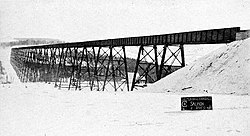
The Little Salmon River trestle is a railway trestle bridge completed in 1911 and still in use in the community of New Denmark, near Grand Falls, New Brunswick, Canada. It is the second largest railway bridge in Canada and the largest railway structure in New Brunswick.
Little Salmon River Trestle | |
|---|---|
 Little Salmon River Viaduct, New Denmark, New Brunswick | |
| Coordinates | 47°01′39″N 67°36′13″W / 47.027522°N 67.603583°W |
| Carries | Rail |
| Crosses | Little Salmon River, New Brunswick |
| Locale | New Denmark, New Brunswick, Canada |
| Other name(s) | Salmon River Trestle |
| Owner | Canadian National Railway |
| Characteristics | |
| Material | Steel |
| Total length | 1,194 m (3,918 ft) |
| Height | 60 m (198 ft) |
| No. of spans | 49 |
| History | |
| Designer | R.F. Uniacke, W. A. Duff, |
| Engineering design by | F. P. Shearwood, Dominion Bridge Company |
| Constructed by | Dominion Bridge Company |
| Construction start | July 27, 1910 |
| Construction end | August 19, 1911 |
| Construction cost | $678,623 |
| Location | |
 | |
The bridge was commissioned in 1906 as a section of the National Transcontinental Railway to span the wide valley of the Little Salmon River, a tributary of the Saint John River. Although the Little Salmon River is relatively small, it follows a deep and wide valley carved by glaciers. Aiming to avoid the steep grades required to descend and cross the river, the National Transcontinental instead designed a long viaduct to cross the entire valley. It was built by the Dominion Bridge Company using 6,346.35 tonnes (13,991,310 lb) of steel for a total cost of $678,623.[1] Construction began on July 27, 1910 using a travelling crane system, prefabricated components and a work crew of 60 to 80 men. The last span was installed on February 9, 1911. Final riveting and painting were completed to open the bridge on August 19, 1911.[2] Despite construction taking place at great heights in all seasons, the work was completed without any accidents or injuries.[3] The bridge's great length made it the second largest in Canada after the Lethbridge Viaduct in Alberta. The National Transcontinental Railway ran into financial difficulties soon after completion, in part due to high construction costs. The line and the bridge was taken over by the Canadian Government Railways in 1915 which became the Canadian National Railway in 1918. The bridge formed a vital direct line between the Port of Halifax and central Canada, and became especially important to move large volumes of freight in the First and Second World Wars. The bridge also carried passenger traffic until January 14, 1990, when local Via Rail service ended.[4] Today it is part of Canadian National's Napadogan Subdivision (Mile 172.5) and continues to carry a heavy volume of freight for Canadian National's mainline between Halifax and Montreal seeing ten freight trains a day.[5]
Specifications
edit- Length: 1,194.397 m (3,918 ft 7+1⁄2 in)
- Height: 60 m (198 ft) above river bed
- Materials: 11,200 tonnes (12,400 short tons) of steel
- Deck spans and lengths:
- 24 plate girder spans each of 17.91 m (58 ft 9 in)
- 25 plate girder spans each of 30.56 m (100 ft 3 in)
- Steel towers: total of 24
References
edit- ^ “8th Annual Report of the Commissioners of the Transcontinental Railway”, Sessional papers of the Dominion of Canada 1913 Vol. 47, No. 37, 1913, p. 40.
- ^ Robert Fitzgerald Uniacke, "The Little Salmon River viaduct : National Transcontinental Railway", The Canadian Society of Civil Engineers (1911), p. 6-7
- ^ Uniacke, p. 11
- ^ Bill Linley, Trackside in the Maritimes 1967-1993, Morning Sun Books (2015), p. 76
- ^ Shane Fowler, “One of Canada's largest train bridges almost forgotten in northwestern N.B.”, CBC News, August 17, 2022