Lewiston is a census-designated place (CDP) in Trinity County, California, United States. Its population is 1,222 as of the 2020 census, up from 1,193 from the 2010 census.
Lewiston | |
|---|---|
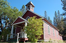
 Lewiston Schoolhouse, in the Lewiston Historic District, is now a library | |
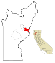
 Location in Trinity County and the state of California | |
| Coordinates: 40°41′57″N 122°48′38″W / 40.69917°N 122.81056°W | |
| Country | United States |
| State | California |
| County | Trinity |
| Area | |
| • Total | 20.009 sq mi (51.824 km2) |
| • Land | 20.009 sq mi (51.824 km2) |
| • Water | 0 sq mi (0 km2) 0% |
| Elevation | 1,814 ft (553 m) |
| Population (2020) | |
| • Total | 1,222 |
| • Density | 61/sq mi (24/km2) |
| Time zone | UTC-8 (Pacific (PST)) |
| • Summer (DST) | UTC-7 (PDT) |
| ZIP code | 96052 |
| Area code | 530 |
| FIPS code | 06-41278 |
| GNIS feature ID | 0277538 |
Geography
editLewiston is located at 40°41′57″N 122°48′38″W / 40.69917°N 122.81056°W (40.699213, -122.810684).[2]
According to the United States Census Bureau, the CDP has a total area of 51.8 square kilometers (20.0 sq mi), all land.
Climate
editAccording to the Köppen Climate Classification system, Lewiston has a hot-summer Mediterranean climate, abbreviated "Csa" on climate maps.[3] It experiences hot summers and cool winters with great diurnal temperature variation.
| Climate data for Trinity River Hatchery, California (normals 1981-2010)(extremes 1921-2020) | |||||||||||||
|---|---|---|---|---|---|---|---|---|---|---|---|---|---|
| Month | Jan | Feb | Mar | Apr | May | Jun | Jul | Aug | Sep | Oct | Nov | Dec | Year |
| Record high °F (°C) | 65.0 (18.3) |
76.0 (24.4) |
84.0 (28.9) |
94.0 (34.4) |
101.0 (38.3) |
109.0 (42.8) |
113.0 (45.0) |
113.0 (45.0) |
108.0 (42.2) |
99.0 (37.2) |
83.0 (28.3) |
67.0 (19.4) |
113.0 (45.0) |
| Mean maximum °F (°C) | 57.0 (13.9) |
67.0 (19.4) |
74.0 (23.3) |
85.0 (29.4) |
92.0 (33.3) |
99.0 (37.2) |
104.0 (40.0) |
104.0 (40.0) |
99.0 (37.2) |
89.0 (31.7) |
70.0 (21.1) |
57.0 (13.9) |
106.0 (41.1) |
| Mean daily maximum °F (°C) | 48.0 (8.9) |
53.8 (12.1) |
59.9 (15.5) |
66.1 (18.9) |
75.4 (24.1) |
84.2 (29.0) |
93.0 (33.9) |
91.0 (32.8) |
86.0 (30.0) |
73.4 (23.0) |
55.4 (13.0) |
46.6 (8.1) |
69.5 (20.8) |
| Daily mean °F (°C) | 40.1 (4.5) |
43.2 (6.2) |
47.7 (8.7) |
51.7 (10.9) |
59.1 (15.1) |
66.2 (19.0) |
72.7 (22.6) |
71.3 (21.8) |
65.4 (18.6) |
56.1 (13.4) |
45.5 (7.5) |
39.2 (4.0) |
54.8 (12.7) |
| Mean daily minimum °F (°C) | 32.3 (0.2) |
32.7 (0.4) |
34.9 (1.6) |
37.3 (2.9) |
42.9 (6.1) |
48.2 (9.0) |
52.5 (11.4) |
50.8 (10.4) |
44.9 (7.2) |
38.8 (3.8) |
35.5 (1.9) |
31.8 (−0.1) |
40.2 (4.6) |
| Mean minimum °F (°C) | 24.0 (−4.4) |
24.0 (−4.4) |
27.0 (−2.8) |
29.0 (−1.7) |
33.0 (0.6) |
39.0 (3.9) |
45.0 (7.2) |
44.0 (6.7) |
37.0 (2.8) |
30.0 (−1.1) |
26.0 (−3.3) |
23.0 (−5.0) |
19.0 (−7.2) |
| Record low °F (°C) | 12.0 (−11.1) |
10.0 (−12.2) |
20.0 (−6.7) |
23.0 (−5.0) |
27.0 (−2.8) |
33.0 (0.6) |
37.0 (2.8) |
38.0 (3.3) |
32.0 (0.0) |
20.0 (−6.7) |
25.0 (−3.9) |
4.0 (−15.6) |
4.0 (−15.6) |
| Average precipitation inches (mm) | 5.68 (144) |
5.07 (129) |
4.21 (107) |
2.31 (59) |
1.74 (44) |
0.80 (20) |
0.17 (4.3) |
0.22 (5.6) |
0.60 (15) |
1.90 (48) |
4.37 (111) |
6.39 (162) |
33.46 (850) |
| Average snowfall inches (cm) | 1.6 (4.1) |
1.6 (4.1) |
0.7 (1.8) |
0 (0) |
0 (0) |
0 (0) |
0 (0) |
0 (0) |
0 (0) |
0 (0) |
0.5 (1.3) |
1.9 (4.8) |
6.8 (17) |
| Average precipitation days (≥ 0.01 in) | 14.3 | 12.4 | 12.1 | 8.6 | 6.6 | 3.1 | 1.2 | 1.3 | 2.4 | 5.7 | 11.4 | 14.1 | 93.2 |
| Source: NOAA[4] | |||||||||||||
History
editA post office called Lewiston has been in operation since 1854.[5] The community was named after Benjamin Franklin Lewis, adopted son of town founder Tom Palmer, who with Lewis ran a gold mining operation on the Trinity River in the early days of the Gold Rush.
Demographics
edit| Census | Pop. | Note | %± |
|---|---|---|---|
| 2000 | 1,305 | — | |
| 2010 | 1,193 | −8.6% | |
| 2020 | 1,222 | 2.4% | |
| U.S. Decennial Census[6] | |||
2010
editThe 2010 United States Census[7] reported that Lewiston had a population of 1,193. The population density was 59.6 inhabitants per square mile (23.0/km2). The racial makeup of Lewiston was 1,074 (90.0%) White, 8 (0.7%) African American, 37 (3.1%) Native American, 6 (0.5%) Asian, 5 (0.4%) Pacific Islander, 21 (1.8%) from other races, and 42 (3.5%) from two or more races. Hispanic or Latino of any race were 78 persons (6.5%).
The Census reported that 1,193 people (100% of the population) lived in households, 0 (0%) lived in non-institutionalized group quarters, and 0 (0%) were institutionalized.
There were 553 households, out of which 112 (20.3%) had children under the age of 18 living in them, 267 (48.3%) were opposite-sex married couples living together, 45 (8.1%) had a female householder with no husband present, 20 (3.6%) had a male householder with no wife present. There were 44 (8.0%) unmarried opposite-sex partnerships, and 3 (0.5%) same-sex married couples or partnerships. 177 households (32.0%) were made up of individuals, and 63 (11.4%) had someone living alone who was 65 years of age or older. The average household size was 2.16. There were 332 families (60.0% of all households); the average family size was 2.70.
The population was spread out, with 202 people (16.9%) under the age of 18, 63 people (5.3%) aged 18 to 24, 212 people (17.8%) aged 25 to 44, 459 people (38.5%) aged 45 to 64, and 257 people (21.5%) who were 65 years of age or older. The median age was 51.4 years. For every 100 females, there were 102.2 males. For every 100 females age 18 and over, there were 100.6 males.
There were 696 housing units at an average density of 34.8 per square mile (13.4/km2), of which 404 (73.1%) were owner-occupied, and 149 (26.9%) were occupied by renters. The homeowner vacancy rate was 3.5%; the rental vacancy rate was 10.2%. 838 people (70.2% of the population) lived in owner-occupied housing units and 355 people (29.8%) lived in rental housing units.
2000
editAs of the census[8] of 2000, there were 1,305 people, 542 households, and 388 families residing in the CDP. The population density was 37.7 inhabitants per square mile (14.6/km2). There were 654 housing units at an average density of 18.9 per square mile (7.3/km2). The racial makeup of the CDP was 89.89% White, 0.23% African American, 2.61% Native American, 0.69% Asian, 0.15% Pacific Islander, 1.76% from other races, and 4.67% from two or more races. Hispanic or Latino of any race were 5.67% of the population.
There were 542 households, out of which 28.2% had children under the age of 18 living with them, 56.3% were married couples living together, 9.4% had a female householder with no husband present, and 28.4% were non-families. 24.2% of all households were made up of individuals, and 11.6% had someone living alone who was 65 years of age or older. The average household size was 2.41 and the average family size was 2.82.
In the CDP, the population was spread out, with 24.5% under the age of 18, 4.0% from 18 to 24, 21.2% from 25 to 44, 32.4% from 45 to 64, and 17.9% who were 65 years of age or older. The median age was 45 years. For every 100 females, there were 102.0 males. For every 100 females age 18 and over, there were 103.5 males.
The median income for a household in the CDP was $30,500, and the median income for a family was $33,889. Males had a median income of $31,667 versus $20,000 for females. The per capita income for the CDP was $16,214. About 16.5% of families and 20.2% of the population were below the poverty line, including 31.5% of those under age 18 and 5.0% of those age 65 or over.
Government
editIn the California State Legislature, Lewiston is in the 2nd Senate District, represented by Democrat Mike McGuire,[9] and the 2nd Assembly District, represented by Democrat Jim Wood.[10]
In the United States House of Representatives, Lewiston is in California's 2nd congressional district, represented by Democrat Jared Huffman.[11]
Places of interest
edit- Lewiston is home to California's third largest reservoir, the Trinity Dam
- The Trinity River flows through the heart of Lewiston, directly under the Old Lewiston Bridge
- Lewiston Lake is located along Trinity Dam Boulevard and is used primarily as a fishing and camping area, and not commonly used as a swimming destination owing to the frigid water.[citation needed]
- Trinity Lake, located just above Lewiston Lake and Trinity Dam, is a summer-time destination for fishing, camping, boating, and swimming.[citation needed]
References
edit- ^ "2010 Census U.S. Gazetteer Files – Places – California". United States Census Bureau.
- ^ "US Gazetteer files: 2010, 2000, and 1990". United States Census Bureau. February 12, 2011. Retrieved April 23, 2011.
- ^ Climate Summary for Lewiston, California
- ^ "Trinity River Hatchery - Euerka, CA NOAA Online Weather Data". NOAA. Retrieved February 13, 2021.
- ^ "Trinity County". Jim Forte Postal History. Retrieved June 16, 2015.
- ^ "Census of Population and Housing". Census.gov. Retrieved June 4, 2016.
- ^ "2010 Census Interactive Population Search: CA - Lewiston CDP". U.S. Census Bureau. Archived from the original on July 15, 2014. Retrieved July 12, 2014.
- ^ "U.S. Census website". United States Census Bureau. Retrieved January 31, 2008.
- ^ "Senators". State of California. Retrieved March 10, 2013.
- ^ "Members Assembly". State of California. Retrieved March 2, 2013.
- ^ "California's 2nd Congressional District - Representatives & District Map". Civic Impulse, LLC. Retrieved March 1, 2013.
