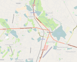
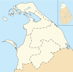
Koomankulam (Vavuniya-04 or Official Name 214F), (Tamil: கூமாங்குளம், romanized: Kūmāṅkuḷam; Sinhala: කුමාංකුලම්, romanized: kumāṁkulam) is a suburb and is considered to be the largest village in Sri Lanka. It is the most populated area in Vavuniya. Administered by Vavuniya South Tamil Pradeshiya Sabha.[1]
koomankulam
கூமாங்குளம் කුමාංකුලම් | |
|---|---|
Suburb | |
| Coordinates: 8°46′34″N 80°27′28″E / 8.77611°N 80.45778°E | |
| Country | Sri Lanka |
| Province | Northern Province, Sri Lanka |
| District | Vavuniya |
| Pradeshiya Sabha | Vavuniya South Tamil Pradeshiya Sabha |
| Weather | |
| Named for | Kūmā Tree |
| Government | |
| • Type | Pradeshiya Sabha |
| • Body | Grama Niladhari |
| Area | |
| • Total | 31.3 km2 (12.1 sq mi) |
| Elevation | 104 m (341 ft) |
| Population | |
| • Total | ~15,000 |
| Time zone | UTC+5:30 |
| Postal Code | 43000 |
| Area code | 024 |
Etymology
editThe village came to be known as Koomankulam due to the abundance of Kūmā trees in the area.[citation needed]
Location
editKoomankulam is located 5.4 km (4.6 mi) away from Vanuniya. It is bordered to the north by Nelukulam, to the east by Ukkulankulam, to the west by Rasenthirakulam, and to the south by Thavasikulam[citation needed]
Education
editKoomankulam Sithivinaygar Vidyalayam
References
edit- ^ "Weather Forecast Koomankulam - Sri Lanka (Northern Province) : free 15 day weather forecasts". La Chaîne Météo (in French). Retrieved 2022-04-01.


