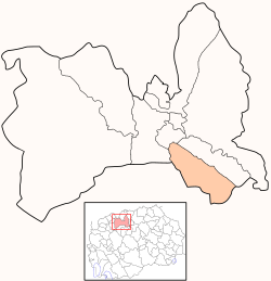
Kisela Voda (Macedonian: ⓘ meaning "mineral water") is one of the ten municipalities that make up the city of Skopje, the capital of North Macedonia.
Municipality of Kisela Voda
Општина Кисела Вода | |
|---|---|
City municipality (Urban) | |
 | |
| Country | |
| Region | |
| Municipal seat | Skopje |
| Government | |
| • Mayor | Orce Gjorgievski (VMRO-DPMNE) |
| Area | |
• Total | 46.86 km2 (18.09 sq mi) |
| Population | |
• Total | 61,965 |
| • Density | 1,242/km2 (3,220/sq mi) |
| Time zone | UTC+1 (CET) |
| Car Plates | SK |
| Website | http://www.kiselavoda.gov.mk |
Geography
editThe municipality borders Karpoš Municipality to the northwest, Centar Municipality to the north, Aerodrom Municipality to the northeast, Studeničani Municipality to the south, and Sopište Municipality to the west.
Demographics
editAccording to the 2002 Macedonia census, this municipality has 125,379 inhabitants, including parts that were later moved to Aerodrom.[1] According to the 2021 North Macedonia census, this municipality has 61,965 inhabitants.[2] Ethnic groups in the municipality include:
| 2002 | 2021 | |||
| Number | % | Number | % | |
| TOTAL | 57,236 | 100 | 61,965 | 100 |
| Macedonians | 52,478 | 91.69 | 52,030 | 83.97 |
| Serbs | 1,426 | 2.49 | 953 | 1.54 |
| Turks | 460 | 0.7 | 732 | 1.18 |
| Vlachs | 647 | 1.13 | 636 | 1.03 |
| Bosniaks | 425 | 0.74 | 581 | 0.94 |
| Roma | 716 | 1.25 | 467 | 0.75 |
| Albanians | 250 | 0.44 | 418 | 0.67 |
| Other / Undeclared / Unknown | 834 | 1.46 | 709 | 1.14 |
| Persons for whom data are taken from administrative sources | 5,439 | 8.78 | ||
Schools
editKrume Kepeski Kiril Pejcinovic Kuzman Josifovski Pitu Partenij Zografski High school Vasil Antevski Dren Nevena Georgieva Dunja
Twin Municipalities
editReferences
edit- ^ 2002 census results in English and Macedonian (PDF)
- ^ "Попис на населението, домаќинствата и становите во Република Северна Македонија, 2021 - прв сет на податоци" (PDF). stat.gov.mk. Retrieved 22 July 2022.
- ^ "Кисела Вода се збратими со Бахчелиевлер од Истанбул". Archived from the original on 2012-08-03. Retrieved 2013-03-21.

