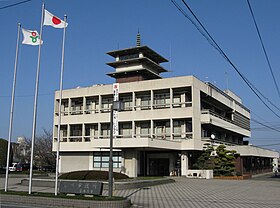
Katsuragi (葛󠄀城市, Katsuragi-shi) is a city located in Nara Prefecture, Japan. As of 1 December 2024[update], the city had an estimated population of 37,809 in 15842 households, and a population density of 1100 persons per km2.[1] The total area of the city is 33.72 km2 (13.02 sq mi).
Katsuragi
葛󠄀城市 | |
|---|---|
 | |
 Location of Katsuragi in Nara Prefecture | |
 | |
| Coordinates: 34°29′21″N 135°43′35″E / 34.48917°N 135.72639°E | |
| Country | Japan |
| Region | Kansai |
| Prefecture | Nara |
| Government | |
| • Mayor | Kazuhiko Ako |
| Area | |
• Total | 33.72 km2 (13.02 sq mi) |
| Population (December 1, 2024) | |
• Total | 37,809 |
| • Density | 1,100/km2 (2,900/sq mi) |
| Time zone | UTC+09:00 (JST) |
| City hall address | 166 Kakinomoto, Katsuragi-shi, Nara-ken 639-2195 |
| Website | www |
| Symbols | |
| Bird | Japanese bush warbler |
| Flower | Peony and chrysanthemum |
| Tree | Quercus gilva and camphor laurel |

Geography
editKatsuragi is located at the eastern foot of the mountain range that stretches from Mount Katsuragi to Mount Nijō, bordered by Osaka Prefecture to the west. Located in the Nara Basin, the climate is cold enough to cause frost in the winter and humid in the summer. Also, since there is little rain throughout the year, there were reservoirs all over the city to deal with water shortages.
Mountains
editNeighboring municipalities
editClimate
editKatsuragi has a humid subtropical climate (Köppen Cfa) characterized by warm summers and cool winters with light to no snowfall. The average annual temperature in Katsuragi is 14.2 °C. The average annual rainfall is 1636 mm with September as the wettest month. The temperatures are highest on average in August, at around 26.4 °C, and lowest in January, at around 2.7 °C.[2]
Demographics
editPer Japanese census data, the population of Katsuragi is as shown below
| Year | Pop. | ±% |
|---|---|---|
| 1960 | 17,428 | — |
| 1970 | 21,431 | +23.0% |
| 1980 | 29,546 | +37.9% |
| 1990 | 33,939 | +14.9% |
| 2000 | 34,950 | +3.0% |
| 2010 | 35,859 | +2.6% |
| 2020 | 36,832 | +2.7% |
History
editThe area of Katsuragi was part of ancient Yamato Province. The city has many temples, shrines and kofun, many which contain important national treasures and important cultural properties. The villages of Shinjō and Taima in Kitakatsuragi District) were established with the creation of the modern municipalities system on April 1, 1889. Shinjō was raised to town status on August 31, 1923 followed by Taima on April 1, 1966. The city of Katsuragi was established on October 1, 2004, from the merger of the two towns.
Government
editKatsuragi has a mayor-council form of government with a directly elected mayor and a unicameral city council of 15 members. Katsuragi contributes one member to the Nara Prefectural Assembly. In terms of national politics, the city is part of the Nara 3rd district of the lower house of the Diet of Japan.
Economy
editKatsuragi is basically a rural area, and the production of knitted goods and socks was popular as a home industry for farmers, but it is now in decline. It also serves as a commuter town for Osaka Prefecture and the neighboring city of Yamatotakada.
Education
editKatsuragi has four public elementary schools and two public junior high schools operated by the city government and one public high school operated by the Nara Prefectural Board of Education.
Transportation
editRailways
editKintetsu Railway - Minami Osaka Line
- Nijō-jinjaguchi - Taimadera - Iwaki - Shakudo
Highways
editLocal attractions
editBuddhist temples
editShrines
editKofun
editOther
editNotable people from Katsuragi
edit- Empress Iitoyo (Iitoyo Tenno)
- Kakinomotono Hitomaro
- Maekawa Samio
- Princess Chujyo (Chujyohime)
- Princess Oku (Okunohimemiko) and Prince Otsu (Otsunomiko)
- Ryōtarō Shiba, author
- Mitsuo Fuchida, Imperial Japanese Navy admiral
References
edit- ^ "Katsuragi City official statistics" (in Japanese). Japan.
- ^ Katsuragi climate: Average Temperature, weather by month
External links
edit- Katsuragi City official website (in Japanese)
- Katsuragi City official website (in English)
- Geographic data related to Katsuragi, Nara at OpenStreetMap


