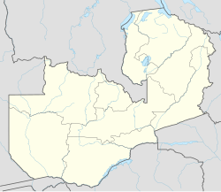
Kasempa is a town located in Kasempa District, North-Western Province, Zambia. It is approximately 550 kilometres (340 mi) by road northwest of Lusaka, the capital.[1] Kasempa is located on the western bank of the Lufupa River as it flows south into the Kafue National Park.[2]
Kasempa | |
|---|---|
| Coordinates: 13°27′18″S 25°50′06″E / 13.45500°S 25.83500°E | |
| Country | |
| Province | North-Western Province |
| District | Kasempa District |
| Elevation | 1,140 m (3,740 ft) |
| Population (2022 Estimate) | |
| • Total | 111 272 |
| Time zone | UTC+2 (CAT) |
| Climate | Cwa |
Population
editAs of December 2022[update], the population of Kasempa from all the boundaries of the district is approximately 111,272.[3]
Landmarks
editThe landmarks within the town limits or close to the edges of the town include:
- Mukinge Mission Hospital is a major hospital for the mission SIM and the Evangelical Church in Zambia (ECZ).
- Kasempa Clinic
- Kasempa Radio Mast
- Kasempa Central Market
- The Junction Between Mumbwa-Kankwenda Highway (D181) and the Kaoma-Kasempa Highway (D301).
- Kasempa Day Secondary School
- Kasempa Primary & Basic School
- Kasempa Boys Boarding School
- Mukinge Girls Secondary School
- Mukinge Day Secondary School
- Mukinge Airport
Climate
edit| Climate data for Kasempa (1961–1991) | |||||||||||||
|---|---|---|---|---|---|---|---|---|---|---|---|---|---|
| Month | Jan | Feb | Mar | Apr | May | Jun | Jul | Aug | Sep | Oct | Nov | Dec | Year |
| Record high °C (°F) | 32.2 (90.0) |
32.6 (90.7) |
33.0 (91.4) |
33.0 (91.4) |
32.0 (89.6) |
30.5 (86.9) |
31.9 (89.4) |
34.0 (93.2) |
36.3 (97.3) |
37.1 (98.8) |
36.9 (98.4) |
33.5 (92.3) |
37.1 (98.8) |
| Mean daily maximum °C (°F) | 27.5 (81.5) |
27.8 (82.0) |
28.0 (82.4) |
28.1 (82.6) |
27.1 (80.8) |
25.7 (78.3) |
25.8 (78.4) |
28.2 (82.8) |
31.6 (88.9) |
32.1 (89.8) |
29.3 (84.7) |
27.7 (81.9) |
28.2 (82.8) |
| Mean daily minimum °C (°F) | 16.9 (62.4) |
16.9 (62.4) |
16.3 (61.3) |
13.9 (57.0) |
9.8 (49.6) |
6.6 (43.9) |
6.7 (44.1) |
9.2 (48.6) |
13.0 (55.4) |
15.4 (59.7) |
16.4 (61.5) |
16.9 (62.4) |
13.2 (55.8) |
| Record low °C (°F) | 11.2 (52.2) |
12.4 (54.3) |
9.1 (48.4) |
5.7 (42.3) |
1.0 (33.8) |
−5.1 (22.8) |
−0.9 (30.4) |
0.0 (32.0) |
1.2 (34.2) |
5.1 (41.2) |
5.0 (41.0) |
12.0 (53.6) |
−5.1 (22.8) |
| Average precipitation mm (inches) | 257.5 (10.14) |
214.7 (8.45) |
171.5 (6.75) |
48.9 (1.93) |
3.6 (0.14) |
0.4 (0.02) |
0.0 (0.0) |
1.0 (0.04) |
4.1 (0.16) |
45.6 (1.80) |
145.9 (5.74) |
253.6 (9.98) |
1,146.7 (45.15) |
| Average precipitation days (≥ 1.0 mm) | 22 | 19 | 15 | 5 | 0 | 0 | 0 | 0 | 1 | 5 | 15 | 22 | 104 |
| Average relative humidity (%) (daily average) | 78.7 | 78.8 | 75.8 | 69.1 | 63.5 | 58.1 | 53.4 | 46.2 | 40.9 | 50.8 | 63.5 | 76.4 | 62.9 |
| Source: NOAA[4] | |||||||||||||
References
edit- ^ Road Distance Between Lusaka And Kasempa With Map
- ^ Location of Kasempa At Google Maps
- ^ https://www.zamstats.gov.zm/ [bare URL]
- ^ "Station Name: KASEMPA MET" (TXT). National Oceanic and Atmospheric Administration. Retrieved 30 August 2024.
13°27′18″S 25°50′06″E / 13.45500°S 25.83500°E
