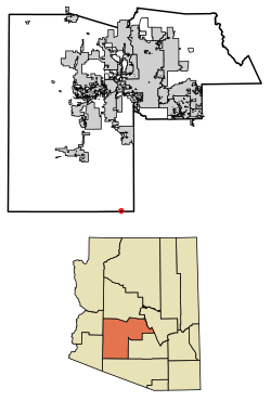
Kaka (O'odham: Gagka, translates as "A Clearing") is a census-designated place (CDP) in Maricopa County, Arizona, United States, located in the Tohono O'odham Nation. The population was 83 at the 2020 census,[3] down from 141 at the 2010 census.
Kaka, Arizona
O'odham: Gagka | |
|---|---|
 Location in Maricopa County, Arizona | |
| Coordinates: 32°30′41″N 112°18′59″W / 32.51139°N 112.31639°W | |
| Country | United States |
| State | Arizona |
| County | Maricopa |
| Area | |
| • Total | 0.50 sq mi (1.29 km2) |
| • Land | 0.50 sq mi (1.29 km2) |
| • Water | 0.00 sq mi (0.00 km2) |
| Elevation | 2,251 ft (686 m) |
| Population | |
| • Total | 83 |
| • Density | 167.00/sq mi (64.48/km2) |
| Time zone | UTC-7 (MST (no DST)) |
| Area code | 928 |
| FIPS code | 04-36780 |
| GNIS feature ID | 2582804[2] |
Toponymy
editIt has frequently been noted on lists of unusual place names.[4]
Geography
editKaka is in southernmost Maricopa County, nearly touching the border with Pima County. It is 88 miles (142 km) south-southwest of Phoenix, 106 miles (171 km) west-northwest of Tucson, and 67 miles (108 km) northeast of the Mexican border at Lukeville.
Demographics
editAt the 2020 census there were 83 people and 28 households living in the CDP.[3][5]
The median household income was $39,573. The per capita income for the CDP was $13,965.[6]
| Census | Pop. | Note | %± |
|---|---|---|---|
| 2010 | 141 | — | |
| 2020 | 83 | −41.1% | |
| U.S. Decennial Census[7] | |||
As of the census[8] of 2010, there were 141 people living in the CDP. The population density was 545.0 people per square mile. The racial makeup of the CDP was 99% Native American and 1% from some other race. 6% of the population were Hispanic or Latino of any race.
References
edit- ^ "2021 U.S. Gazetteer Files: Arizona". United States Census Bureau. Retrieved May 16, 2022.
- ^ a b U.S. Geological Survey Geographic Names Information System: Kaka, Arizona
- ^ a b c "Kaka CDP, Arizona: 2020 DEC Redistricting Data (PL 94-171): P1. Race". U.S. Census Bureau. Retrieved May 16, 2022.
- ^ Parker, Quentin (2010). Welcome to Horneytown, North Carolina, Population: 15: An insider's guide to 201 of the world's weirdest and wildest places. Adams Media. p. x. ISBN 9781440507397.[permanent dead link]
- ^ "Kaka CDP, Arizona: 2020 DEC Redistricting Data (PL 94-171): H1. Occupancy statistics". U.S. Census Bureau. Retrieved May 16, 2022.
- ^ "Kaka, AZ Profile: Facts & Data". Arizona.hometownlocator.com. 2021. Retrieved August 24, 2021.
- ^ "Census of Population and Housing". Census.gov. Retrieved June 4, 2016.
- ^ "American FactFinder". Archived from the original on July 21, 2011. Retrieved April 23, 2011.

